Month: November 2020
-
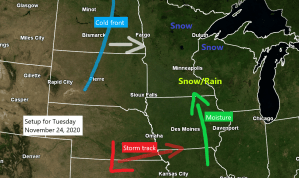
Some more snow possible Tuesday
18.2″ of snow so far this month at Duluth, Minnesota. Normal snowfall for November is 13.7″. Although November 2020 has featured above normal snowfall in Duluth, will still need an additional 7.5″ of snow the rest of this month to get into the top 10 snowiest Novembers on record list,…
-
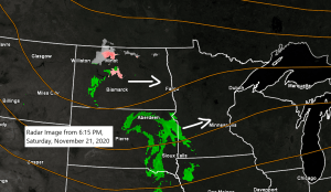
Some snow on the way late tonight into Sunday morning
An area of low pressure will move quickly across the Dakotas and Minnesota tonight into Sunday morning, this low will exit to the NE by Sunday afternoon. A brief period of stronger atmospheric lift will accompany this system which should go on to produce an expanding area of precipitation across…
-
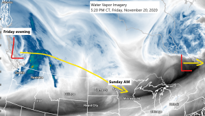
Some wet snow or a mix of precip possible late Saturday night-Sunday morning and again next Tuesday
System which will affect the Northland late Saturday night-Sunday morning is moving into British Columbia this afternoon, and this system will move quickly to the ESE over the weekend. Source: https://www.star.nesdis.noaa.gov/ A quick moving system digs SE through the northern Plains and upper Midwest late Saturday into Sunday morning, as…
-
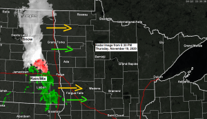
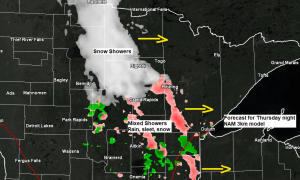
A wintry mix possible late tonight; few snow showers and cooler Friday; watching snow chances late Saturday night-Sunday
A mixture of precipitation types ranging from snow to rain to sleet and possibly even a bit of freezing rain is expected to move quickly through northeast Minnesota and northwest Wisconsin later this evening into early Friday morning. Although precipitation amounts should remain light tonight, there could be enough snow/sleet…
-
Mild Thursday; turning a little cooler (near normal temps) this weekend; a couple chances for light precipitation thru Sunday
We have three shots for some precipitation over the next few days. The first chance comes Thursday morning when we could see a few rain showers mainly across northern Minnesota, and then will see another chance for some showers across most of the Northland Thursday night, and these showers could…