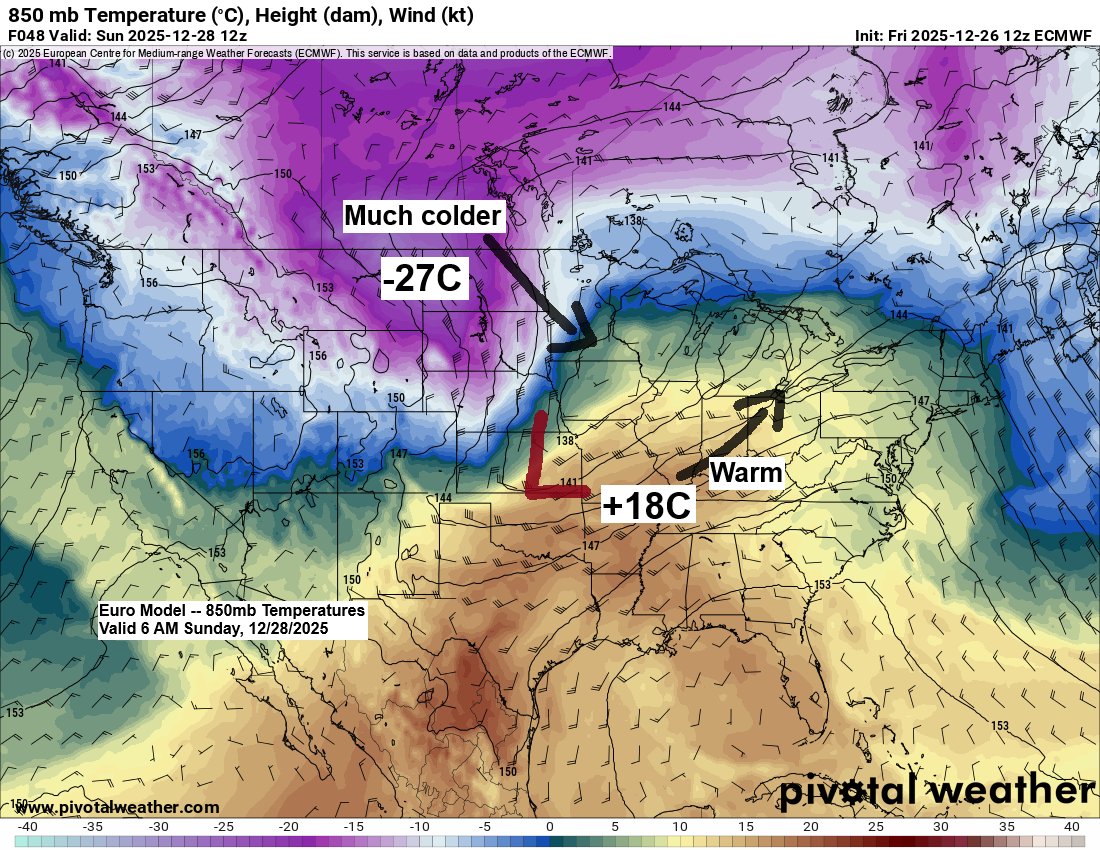
Arctic air and strong north to northwest winds will sweep into northeast Minnesota and northwest Wisconsin from Sunday into Monday as low pressure moves northeast from eastern Kansas and western Missouri, while strong high pressure builds southeast into the northern Plains. The tight pressure gradient between these systems, along with strong cold air advection, will bring windy conditions to the Northland. Expect wind gusts of 15 to 30 mph, with stronger gusts of 30 to 50 mph near Lake Superior, especially Sunday evening into Monday.
As temperatures drop from mild to much colder, some snow is expected from Sunday through Monday morning, with precipitation possibly beginning as rain or a mix, with the changeover to snow spreading east across the Northland during the day Sunday. Temperatures will drop on Sunday from the 30s early in the day to the single digits, teens, and 20s by Sunday afternoon/evening.
While a major winter storm isn’t likely for most of the Northland, the South Shore of Lake Superior in northern Wisconsin could see higher accumulations, with system snow mixing with lake effect snow.
In Duluth, Sunday’s low is tracking too far south to bring much snow, with the system expected to pass near or southeast of Chicago before reaching Lake Huron by Monday morning. For a bigger snowstorm here, the low would need to hook more north-northeast through central or northeast Wisconsin, but that doesn’t seem likely. The system also looks fairly progressive, which has been the trend lately with no blocking to slow it down. Winds are expected from the north to northwest, which usually doesn’t favor heavy snow in Duluth, though there have been exceptions, but more often than not, that wind direction limits snowfall.

This is my early snowfall forecast, valid from Sunday afternoon ending 12 PM Monday. Expect updates and changes to this outlook over the weekend
- Highest totals along the South Shore with 6″+
- Inland areas of northwest Wisconsin, away from the South Shore, could get between 3 and 6 inches of snow.
- Snowfall totals are expected to be lower, generally ranging from 1 to 3 inches, across northeast and east central Minnesota, including Duluth and Superior.

One thing to keep an eye on with model trends is how soon the dry air moves in on Sunday, as that will be tied to when the arctic air arrives, which could affect how long the snow sticks around in the Northland. If the moisture lingers into the colder air, snow totals could end up higher, so it’s something to watch over the next 24–36 hours.
The map shows above-normal moisture levels highlighted in green and blue, while areas shaded in gray indicate below-normal moisture.

…Hazards map…
A winter storm watch is in effect for parts of northern Wisconsin and much of upper Michigan from Sunday afternoon through Monday.
Lake Superior is under both a storm watch and a gale watch, with the potential for north to northwest winds reaching gale to storm force from Sunday evening into Monday. Waves could reach heights of 16 to 21 feet in the storm watch area and 4 to 15 feet in the gale watch zone.
Note: The NWS could issue additional winter weather alerts farther west within the next 24 hours, so stay tuned for updates.

…Strong Winds and Blowing Snow Potential Sunday into Monday…
Euro model wind gust forecast valid 6 AM Sunday to 6 PM Monday.

…Foggy conditions…
Expect favorable conditions for areas of fog across much of the region from tonight through Sunday morning. At times, the fog may become dense, cutting visibility to less than a mile in areas marked in pink on the loop below.
HRRR model visibility forecast through 7 AM Sunday.

Fog will be joined by a chance of rain or a wintry mix at times on Saturday in parts of northeast Minnesota and northwest Wisconsin. The wintry mix could bring a light glaze of ice, especially in northern Minnesota and the Arrowhead. Otherwise, precipitation amounts should stay fairly light through Saturday night.
HRRR model simulated radar forecast through 12 AM Sunday.

Weather conditions remain all over the place, with arctic air gripping much of Canada and record warmth stretching from the Rockies to the central and southern Plains. An ice storm hit parts of lower Michigan today as part of a winter storm expected to impact the northeast U.S. tonight. Meanwhile, Montana experienced thunderstorms, including a severe thunderstorm warning earlier in the day.
This afternoon saw temperature extremes ranging from a warm 86 degrees in Dallas, Texas, to a frigid -50 degrees in Mayo, Yukon, Canada.

This afternoon, temperatures soared 20 to 30 degrees above normal across a broad swath from the Rockies through the Ohio Valley and down into the southern Plains.

The orange and red circles mark locations that matched or surpassed their daily record high temperatures as of 3 PM CT on Friday, December 26.

Leave a Reply