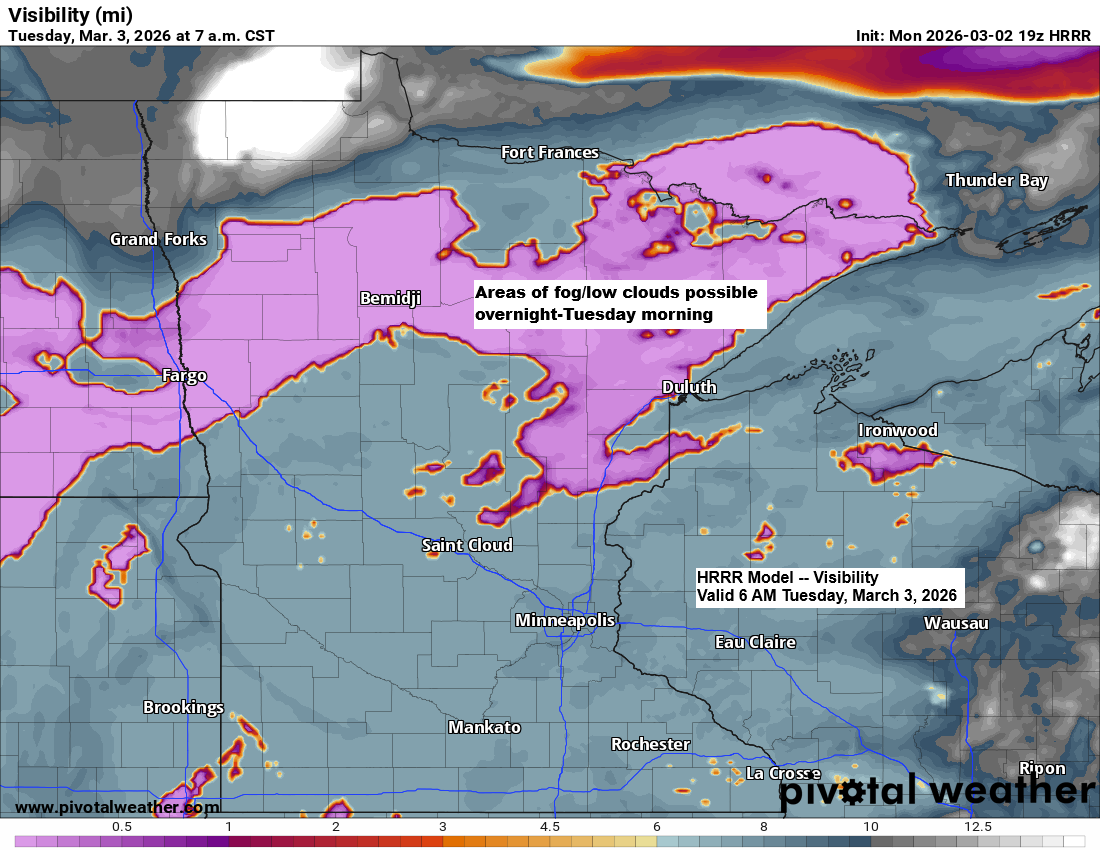
With some snowmelt today and more expected in the coming days, there’s a good chance we’ll see low cloud cover and patches of fog forming in the Northland over the next few nights and mornings.
Temperatures made a nice comeback today after the bitter cold over the weekend, with highs reaching the upper 30s to lower 40s in northeast Minnesota and northwest Wisconsin. Similar highs are expected Tuesday, with a few spots possibly hitting the mid-40s.
Wednesday could turn out to be one of the warmer days this week, with highs possibly climbing into the mid-40s to low or even mid-50s in the Northland.

As is often the case in early March, we’re experiencing a mix of winter, spring, and even a touch of early summer warmth.
In much of Canada, it’s bitterly cold, with temperatures dropping from the teens below zero to as low as 40 below. Farther south, though, it’s a whole different story, with warm weather and temperatures in the 70s and 80s.
This clash of air masses often stirs up larger storm systems around this time of year, and that could happen at times over the next few weeks. However, there’s no guarantee these systems will bring precipitation to northeast Minnesota or northwest Wisconsin, but it’s a pattern worth keeping an eye on.

…Late week precipitation chances…
It’s becoming more likely that the Northland will see some precipitation later this week, with the main activity expected between Friday and Saturday.
Energy moving southeast from the northern Rockies could join with additional energy pushing east-northeast from the southern and central Rockies to bring some precipitation to our area later this week. However, it currently appears the system won’t fully come together, likely resulting in mostly light precipitation.
Temperatures should stay warm enough for most of the precipitation from Friday into early Saturday to come down as rain, with minimal risk of ice. Toward the end of the system, some cooling might cause the rain to mix with or briefly turn into wet snow, but significant accumulation isn’t expected at this point. Still, conditions could change over the next few days.

…Severe thunderstorm risk mid to late week…
The risk of severe thunderstorms will increase in the coming days, with scattered to isolated severe storms expected each day from Wednesday through at least Saturday.
Mid to late week, the main severe weather threats will be large hail and strong, damaging winds, with the chance of a few tornadoes also in the mix.
The highest risk on Wednesday stretches from north Texas to western Arkansas.

The main risk on Thursday is centered over areas of west and north Texas, extending into western Oklahoma.

A wide area faces the threat of severe storms on Friday, reaching as far north as southern Iowa and spanning across the central and southern Plains.

On Saturday, the risk moves further south, covering parts of north Texas, southeast Oklahoma, and a small portion of western Arkansas.

On average, March sees about 95 tornadoes across the U.S., based on climate data from 2000 to 2024. Texas tops the list, averaging 15 tornadoes during the month.

So far in 2026, 75 tornadoes have been reported in the U.S., which is slightly below the average of 114 by March 1st.

So far this year, the states with the most tornadoes are Mississippi with 25, followed by Louisiana with 21, and Illinois coming in third with 11.
Here’s a look at where tornadoes have occurred so far in 2026.

Leave a Reply