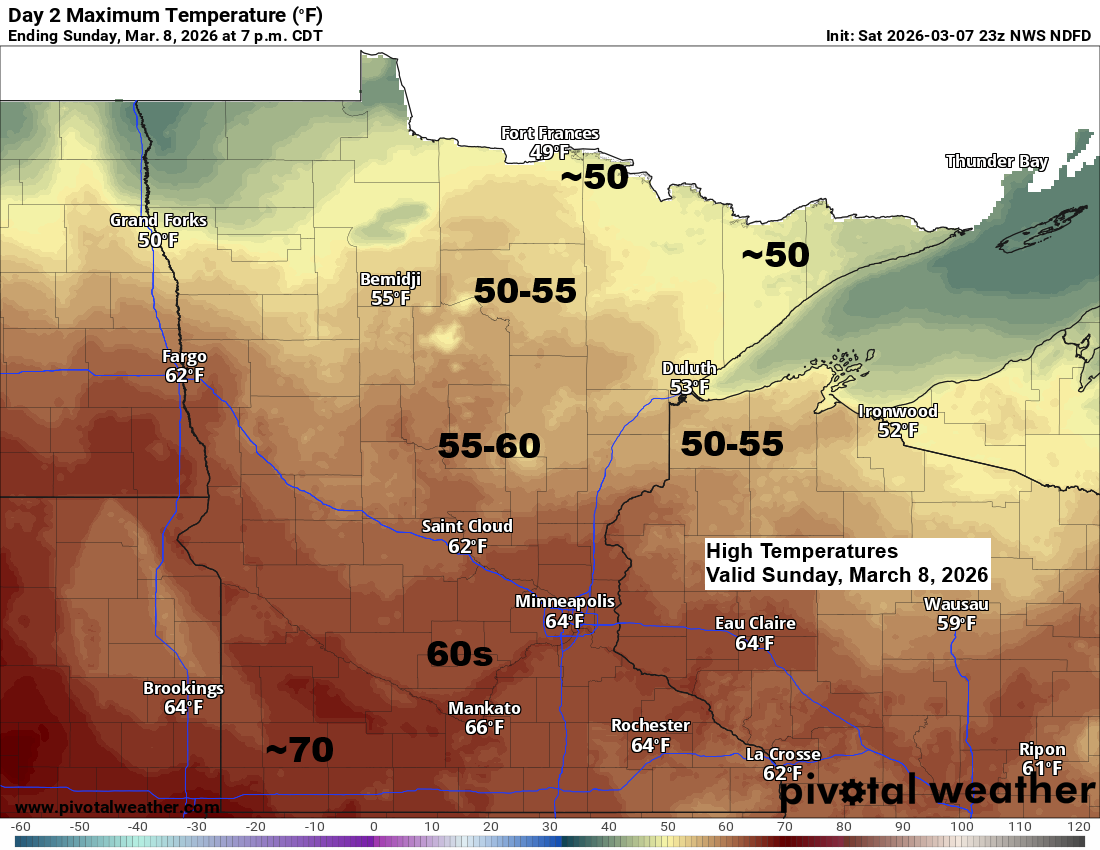
A few snow or rain showers could pop up over northern Minnesota late tonight, with a few more showers possible Sunday night as two clipper systems move north of the area. Otherwise, Sunday should see highs in the 40s and 50s across northeast Minnesota and northwest Wisconsin, with far southern areas possibly nearing 60 degrees. Some spots in southern Minnesota might even approach 70 by Sunday afternoon.
The last time temperatures hit 50 degrees or warmer at the Duluth Airport was November 24th, 2025, with a high of 53. We’ll see if Sunday brings our first official 50-degree day of the year, which typically happens around March 20th.
It’s still March, and the Northland could see a couple of chances for snow next week—the first between Monday night and Wednesday morning, and another later in the week. Forecast models are still uncertain on totals, with some showing light amounts under 2 inches, while others suggest a more significant snowfall. Stay tuned.
HRRR model simulated radar forecast through 7 AM Monday.

Early to mid next week could bring some overrunning snow to parts of the Northland as moisture moves north into a cooler air mass, while low pressure shifts east or east-southeast from the northern Rockies and western High Plains. Once again, computer models disagree on how much snow this setup might produce.

There was a skiff of snow earlier this morning, but if you’re a late riser, you wouldn’t have even known it had snowed.

Snowfall reports for March 7, 2026
- Brimson, MN: 2.2″
- Gile, WI: 2.0″
- Pequot Lakes, MN: 2.0″
- Pillager, MN: 1.8″
- Grantsburg, WI: 1.8″
- Floodwood, MN: 1.8″
- Sawbill Lake, MN: 1.8″
- Webb Lake, WI: 1.6″
- Shaw, MN: 1.5″
- Deerwood, MN: 1.5″
- Wales, MN: 1.5″
- Leader, MN: 1.5″
- Brainerd, MN: 1.5″
- Hertel, WI: 1.4″
- Libby, MN: 1.3″
- Baxter, MN: 1.2″
- Crosby, MN: 1.1″
- Jacobson, MN: 1.0″
- Hovland, MN: 1.0″
- Hoyt Lakes, MN: 1.0″
- Duluth, MN: 0.2″ (official total at the NWS)
Note: Duluth saw 0.22 inches of precipitation from Friday through early Saturday morning.
Here’s a look at the 24-hour precipitation analysis.

Leave a Reply