Snow chances return to the Northland Monday night through midweek, with the possibility of another round later in the week.
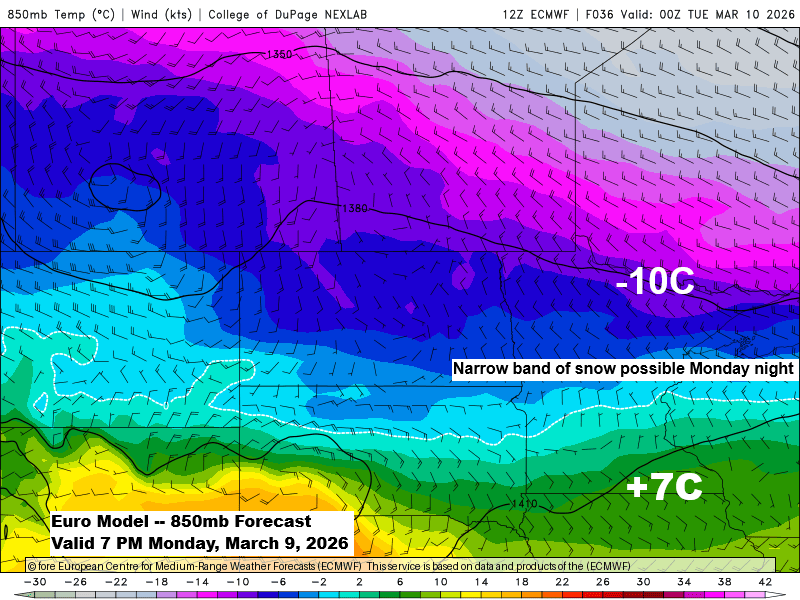
The first system is shaping up to be pretty complex, with the potential for two separate rounds of snow. The first round could come from some FGEN forcing and a setup where colder air to the north meets warmer air to the south, possibly creating a narrow band of snow that might affect a small part of the Northland late Monday night into early Tuesday morning. Because this band looks so narrow, even a small shift in its position could change where the snow piles up. Areas under the band could see about 0.5 to 2 inches of accumulation by 7 AM Tuesday.
A second round of snow hinges on the path of a low-pressure system moving over the central Plains on Tuesday and how much moisture drifts north to meet a trough from the northern Plains. Most likely, this second band of snow will form from southern Minnesota into central Wisconsin, leaving much of northeast Minnesota and northwest Wisconsin dry from Tuesday afternoon through Wednesday morning.
For Duluth: Some snow could fall early Tuesday morning, with totals between about half an inch and two inches. A few snow showers may stick around during the day, but little additional accumulation is expected. Another round of snow might move in Tuesday evening into Wednesday morning, though it looks like it will pass south of the Twin Ports.
NWS Blend of Models total snowfall through 7 PM Wednesday, March 11, 2026.

…Severe Thunderstorms Tuesday…
On Tuesday, a weather system could bring scattered severe storms across a wide area from the southern Plains to the southern Great Lakes. An enhanced risk, or level 3 out of 5, is in place for severe thunderstorms in northeast Missouri, far southeast Iowa, and central Illinois. All severe hazards are possible, including large hail, damaging winds, and tornadoes, with the potential for a few strong EF2+ tornadoes.

…Today’s weather…
Today, the Northland was in the warm sector between two strong low-pressure systems—one near Hudson Bay, Canada, at 979mb (28.91 inches), and the other over southwest Manitoba and far northern North Dakota late this afternoon with a pressure of 989mb (29.21 inches).
With breezy southwest winds and plenty of warm air moving in, temperatures rose into the upper 40s and lower 50s in northeast Minnesota and northwest Wisconsin today. Southern Minnesota enjoyed highs in the 60s, while much of South Dakota saw 70s, including a warm 71 in Sioux Falls.
Note: Duluth Airport hit a high of 51 degrees today, March 8, 2026, marking the first 50-degree day of the year, which usually happens around March 20. Last year’s first 50-degree day was also close to this date, occurring on March 9.

A few showers might pass through northern Minnesota tonight, with rainfall amounts between 0.05 and 0.15 inches limited to the far north, and just trace amounts expected farther south toward Grand Rapids and Hibbing.

…2025-2026 seasonal snowfall update…
Here’s a look at the snowfall totals for the 2025–2026 season as of 7 AM on March 8, 2026.
The big winners this winter, unsurprisingly, are the areas downwind of Lake Superior and Lake Michigan, which have already seen anywhere from 72 to over 120 inches of snow this season.
Marquette, Michigan has already been buried under 208.4 inches of snow this season, a staggering 50 inches more than their typical average.
In contrast, Duluth, Minnesota has received 55.1 inches of snow so far this season, which is 16.6 inches below the normal amount for this time of year.

Leave a Reply