Updated snowfall stats for Duluth, Minnesota
Month to date total: 15.7 inches
Departure: +9.4 inches above normal
Seasonal total for 2025-26: 70.6 inches
Departure: -3.2 inches below normal
Note: By March 13th, Duluth has gotten about 26 inches more snow this winter than it did last winter.
Duluth has been hit with a snowy stretch lately, recording 30.8 inches of snow since February 17th—less than a month. That’s already more than the combined snowfall for December and January, which totaled just 22 inches.
From March 12 to 13, Duluth saw 9.3 inches of snow with 0.61 inches of total precipitation, giving a snowfall ratio of 15:1—just a bit higher than the usual 12:1 we get around here.
After a break from the active weather tonight, the next storm set to hit parts of the upper Midwest and Great Lakes will start Saturday evening and last through Monday.
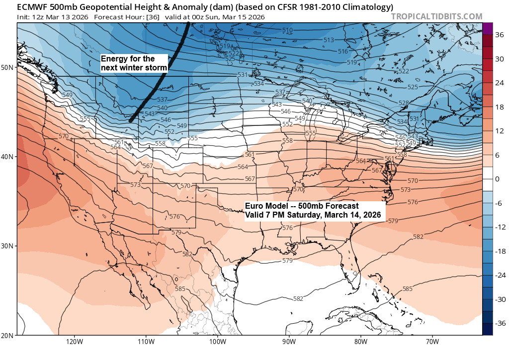
This storm will bring a deepening upper trough sliding southeast from the northern Rockies on Saturday. As it progresses, the trough is expected to strengthen a lot and could even take on a negative tilt, with the 500mb low closing off by Monday over the eastern Great Lakes.


…Weekend setup…
High pressure stretching from Saskatchewan to Hudson Bay in Canada will bring plenty of dry air southward, while low pressure over the western High Plains moves east-southeast into northern Missouri, then lifts northeast toward Chicago, IL, or slightly east of there by Sunday night.

…Weekend Winter Storm…
Snowfall amounts for this weekend’s storm in northeast Minnesota and northwest Wisconsin are pretty uncertain. Some computer models are shifting the heavier snow farther north, while others still show the biggest totals staying mostly south of the area or just brushing the far southern parts.
For now, I’m favoring the computer models that keep the snow shield farther south based on how the pattern is shaping up, so here are my early snowfall estimates from Saturday night through early Monday morning.
Stay tuned for updates over the next 24 hours, as I might need to make some changes—potentially significant ones—to my forecast.
In the Duluth area, expect up to an inch of snow late Saturday night into Sunday.
Snowfall totals of 4 to 7 inches or more are expected from Hinckley to Hayward and points south, while areas farther north, including the Bayfield Peninsula and west to Moose Lake, Aitkin, and Brainerd, will mostly see 1 to 4 inches.

GFS model simulated radar forecast valid 1 PM Saturday to 7 PM Sunday.

…Strong Winds Sunday-Monday…
Northeast Minnesota and northwest Wisconsin can expect another bout of windy weather on Sunday and Monday, with northerly winds with gusts ranging from 20-30 mph and occasionally topping 40 mph, especially near Lake Superior and throughout northwest Wisconsin.
Strong winds may lead to blowing and drifting snow in parts of the Northland from Sunday to Monday.
Euro model wind gust forecast valid 7 AM Sunday to 7 PM Monday.

…National Weather Service Winter Weather Alerts late Saturday to Monday…

…Severe Thunderstorm Potential Sunday…
Severe thunderstorms are becoming more likely on Sunday across a wide area from northeast Texas to southern Lower Michigan, with damaging winds and a few tornadoes posing the main threats.

Leave a Reply