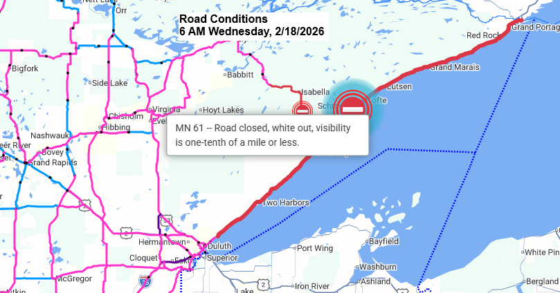
- Highway 61, stretching from Duluth to the Canadian border, is closed this morning because of ongoing blizzard conditions.
- Highway 1, from near Isabella to Highway 61, is closed as well because of the blizzard.
- A no travel advisory is in effect due to whiteout conditions along a stretch of I-35 from near Scanlon and Esko to Eldes Corner, as well as on Minnesota 33 from Independence to around Grand Lake.
- No travel is advised due to whiteout conditions on I-35 from around Sturgeon Lake to Moose Lake, including Barnum, Mahtowa, Atkinson, and Otter Creek.
As of 6 AM Wednesday, Minnesota Power reported 104 outages affecting about 1,500 customers.

There were a few instances of thundersnow in northeast Minnesota late Tuesday night and early Wednesday morning, including in Duluth, Grand Rapids, and Silver Bay.

Since midnight, peak wind gusts have hit 66 mph at Duluth Airport and 62 mph at Duluth Sky Harbor Airport, with a report of a 67 mph gust along Highway 210 in the Jay Cooke area.
East winds of 30 to 60 mph will persist in Duluth for most of the day, with the strongest gusts expected through early to mid-afternoon. Winds won’t ease to around 15 to 30 mph until late tonight or early Thursday morning.

The National Weather Service has extended the Blizzard Warning farther southwest to include Duluth. It’s in effect until 12 PM Thursday, though it might be canceled early for Duluth. However, it will probably continue farther up the North Shore through Thursday morning.

The low pressure system responsible for this blizzard along the North Shore was over far western Minnesota near Fergus Falls at 7 AM with a central pressure down to 983mb or 29.03 inches. This low will track slowly east through early Thursday morning.
At 7 AM this morning, temperatures in Duluth ranged from 28 to 32 degrees. They likely won’t change much throughout the day, maybe climbing just a couple of degrees from where they are now.
-Duluth will see its heaviest snowfall through mid-morning today, with lighter snow likely sticking around into the afternoon all the way to early Thursday morning. As the snow eases, there could also be some drizzle, freezing drizzle, or even a few ice pellets.
Euro model simulated radar forecast through 6 AM Thursday.

Leave a Reply