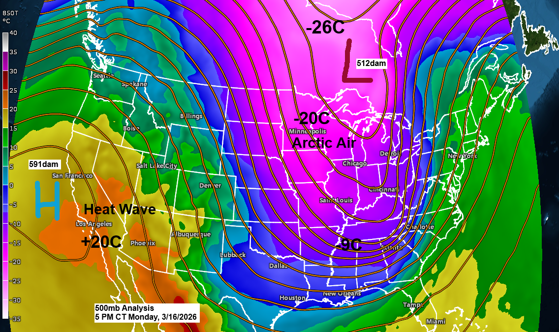
A large, deep trough extended from central Canada down through the upper Midwest and Great Lakes to the southern U.S. today, bringing unusually cold air for this time of year. At 850mb, temperatures dropped to an impressive -20°C in northeast Minnesota and reached -9°C as far south as northern Mississippi, stretching east into north Georgia, where some snow fell.
This afternoon, temperatures in northeast Minnesota and northwest Wisconsin were only in the teens, which is surprising given how much sunshine we had across much of the area. Typical highs for March 16th are in the mid-30s to around 40 degrees, so today ended up about 20 degrees colder than usual.

…Frigid tonight…
With winds easing and skies staying mostly clear tonight, temperatures will plunge to around zero to 15 below in much of northeast Minnesota and northwest Wisconsin, with some areas possibly dipping to around 20 below.
Although it will be cold tonight, no record lows are likely to be broken in our area.
Record Lows for Tuesday, March 17
- International Falls, MN: -33 set in 1897
- Hibbing, MN: -24 set in 1989
- Ashland, WI: -21 set in 1916
- Brainerd, MN: -18 set in 2013
- Duluth, MN: -15 set in 1941

Updated Snowfall Stats for Duluth, Minnesota
Month to date: 17.7 inches
Departure: +10.2 inches above normal
2025-2026 total: 72.6 inches
Departure: -2.4 inches below normal
Since January 1st, we’ve had 3.32 inches of precipitation, which is 0.68 inches above the average up to March 16.
…Clipper Tuesday night…
A clipper system is expected to bring another round of snow to the Northland late Tuesday afternoon into Tuesday night. The snow will likely be light and fluffy, lasting only a couple of hours before moving out of the area.
Duluth area: Snow is expected to start between 4 and 6 PM on Tuesday and taper off between 1 and 3 AM on Wednesday.
NAM 3km model simulated radar forecast valid 1 PM Tuesday to 7 AM Wednesday.

Northeast Minnesota and northwest Wisconsin are in for about an inch of fluffy snow Tuesday night, with some spots getting up to 2 inches. The North Shore might see as much as 3 inches thanks to a bit of lake enhancement.
Note: Duluth is expected to get about 1 to 2 inches of snow Tuesday night.

…Heat and Freeze…
An early-season heat wave is building across the southwest U.S. over the next few days, triggering heat alerts, while much of the southeast braces for a freeze on Tuesday morning. Yet, those same areas expecting a freeze will be back in the 80s by the end of the week—talk about wild temperature swings!

Leave a Reply