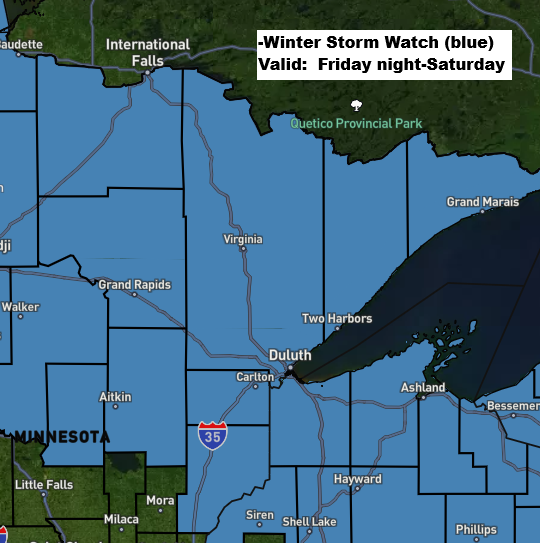
A second winter storm is expected to hit northeast Minnesota and northwest Wisconsin Friday night, continuing into Saturday. A winter storm watch is in place for the entire Northland, with the potential for heavy snow, freezing rain, and mixed precipitation.
Tonight’s storm will move out to the east by Friday morning, while another winter storm is approaching from the west. This one brings a strong mid and upper-level low that will track east-northeast from the northern Rockies, across the northern Plains on Friday, and into the upper Midwest by Saturday.

Here’s my preliminary snowfall forecast valid late Friday night to Saturday.
Note: Duluth may see 1 to 3 inches of snow and some sleet. Snow amounts could increase if the storm track shifts.
It looks like this second storm will bring the most snow to north central Minnesota, with totals between 5 and 12 inches possible, and the heaviest snowfall expected in the far north near International Falls.

The upcoming storm from Friday night into Saturday will bring some icy conditions, with the highest chance for freezing rain and ice expected southeast of Duluth in parts of northern Wisconsin, where ice could build up to 0.1 to 0.25 inches.

Duluth area: Expect a wintry mix of sleet and snow late Friday night, with a chance of spotty freezing rain, followed by snowfall throughout the day on Saturday. Another round of northeast winds is expected from Friday night into Saturday morning, with gusts ranging from 15 to 30 mph.
NAM 3km model simulated radar forecast valid 7 PM Friday to 7 PM Saturday.

Leave a Reply