April begins on Wednesday – Here are the Climate Averages & Records for the month of April at Duluth, Minnesota.
| Normals for April Normal high on the 1st: 41 F Normal high on the 30th: 57 F Normal low on the 1st: 24 F Normal low on the 30th: 36 F Averages for April Temperature: 39.6 F Precipitation: 2.43″ Snowfall: 6.9″ Number of days with at least 0.1″ snowfall: 4 Number of days with at least 1.0″ snowfall: 2 Number of days with a high of at least 50 F: 11 Number of days with a high of at least 60 F: 5 Number of days with a high of at least 70 F: 1 Mean date for 1st 60 degree temperature: April 12 Mean date for 1st 70 degree temperature: April 28 Records for April Warmest: 46.1 F set in 1987 Coldest: 28.7 F set in 1950 Wettest: 8.18″ set in 2001 Driest: 0.24″ set in 1987 Snowiest: 50.8″ set in 2013 Least snowiest: 0.0″ set in 1976 Astronomical Data for April Sunrise on the 1st: 6:47 AM CDT Sunrise on the 30th: 5:54 AM CDT Sunset on the 1st: 7:39 PM CDT Sunset on the 30th: 8:17 PM CDT |
Past April Snowfall Totals for Duluth, Minnesota from 2000-2019
| Average Snowfall for April in Duluth is 6.9″ 2000: 5.6″ 2001: 7.7″ 2002: 11.6″ 2003: 12.9″ 2004: 0.3″ 2005: 0.5″ 2006: Trace 2007: 12.7″ 2008: 14.6″ 2009: 1.2″ 2010: Trace 2011: 10.6″ 2012: 0.6″ 2013: 50.8″ (snowiest April on record) 2014: 26.3″ (3rd snowiest April on record) 2015: 1.2″ 2016: 9.8″ 2017: 1.9″ 2018: 18.5″ (8th snowiest April on record) 2019: 6.5″ |
Upper level ridge keeping things quiet in the Northland today.
Source: RAP model; https://www.spc.noaa.gov/

Here’s a look at how much precipitation could fall through 7 PM Thursday, April 2.
Greatest amounts across northwest Minnesota into the Dakotas, much lower totals through Thursday across northwest Wisconsin and most of northeast Minnesota.
Source: https://lab.weathermodels.com/

Simulated radar forecast valid from 7 AM Wednesday to 7 AM Thursday. Looks mainly dry in northeast Minnesota and northwest Wisconsin on Wednesday, but some scattered showers are possible for Wednesday night.
Source: 18z NAM-WRF model 3.31.20; https://weathermodels.com/

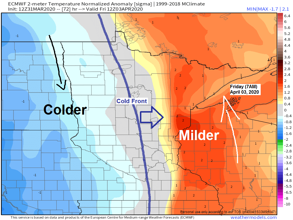
Still looks like the best chances for accumulating snow the next few days will remain well west of the Northland, but as colder air moves further east on Friday some parts of the Northland could see some wet snow with minor accumulations Friday or Friday night.
Source: 12z European ensemble model 3.31.20; https://weathermodels.com/index.php?r=site%2Fstart

We did see some low clouds move off Lake Superior into the Twin Ports for a few hours this morning, but these burned off quickly by this afternoon. Most of the low cloud cover this afternoon is out over Lake Superior, south into far northern Wisconsin and upper Michigan.
Source: Goes-16 visible imagery; https://weather.cod.edu/

Low temperature forecast for Wednesday morning, April 1, 2020. Source: https://lab.weathermodels.com/

High temperature forecast for Wednesday, April 1, 2020.

…Weather Summary…
Clear to partly cloudy skies will be found across the Northland tonight with patchy low clouds/fog possible around Lake Superior. Lows tonight will be in the 20s with teens possible in the typical cold spots. Winds will be out of the east at 5 to 15 mph.
Partly to mostly cloudy Wednesday. Moisture advection increases on southerly winds with precipitable water increasing from <0.25″ Wednesday morning to around 0.50-0.80″ by late Wednesday evening. A few showers are possible in north-central/east-central Minnesota Wednesday afternoon, but a better chance for some showers will occur Wednesday night. Note: There is a slight chance for an isolated thunderstorm Wednesday night due to some weak elevated CAPE, but for the most part the threat for thunder is very low. Highs on Wednesday will be in the 40s to lower 50s with 30s near Lake Superior. Winds will be out of the east to southeast at 10 to 20 mph.
A cold front will move slowly east across the upper Midwest Thursday and Friday. A very moist air mass will be found ahead of this front late this week with PWATS upwards of 0.75 to around 1.00″, very high for early April! Will likely get some rain at times in northeast Minnesota and northwest Wisconsin Thursday and Friday with the best chance for rain on Thursday across north-central Minnesota, then will see rain chances increase farther east on Friday.
Some wet snow and freezing rain is also possible on Friday, mainly across western portions of the area.
Dry weather returns on Saturday, but wet weather is possible at times beginning late Sunday and lingering into the middle of next week.
Forecast for Duluth and Superior
.Tonight… Partly to mostly cloudy. Low 25 to 30. Wind east 10 to 20 mph.
.Wednesday… Partly to mostly cloudy. Some showers possible mainly Wednesday night. High 35 to 40. Wind east 10 to 20 mph.
.Thursday… Mostly cloudy. Patchy fog and drizzle possible along with some rain showers. High 35 to 40. Wind east 10 to 20 mph.
| Normal temperatures for April 1 High 41 Low 24 Sunrise Wednesday 6:47 AM CDT Sunset Wednesday 7:39 PM CDT |
Thanks for reading!
Tim
Leave a Reply