6:50 PM Friday, March 1, 2024
We’ve seen lots of changes in our weather over the last 7 days.
Last Friday’s Lake effect snow event in Duluth with some parts of the city getting 3 to 6 inches of snow in a few hours, this was followed by temperatures in the 40s and 50s last weekend with 60s and even some 70s in southern Minnesota earlier this week, and then we saw a powerful arctic front plow through the area midweek with subzero temperatures returning to the Northland for the first time since about mid-January, including lows in the 20s below zero in northern Minnesota, and far northern Minnesota was also hit by a winter storm which dropped several inches of snow earlier in the week, and then we wrapped it all up with more record breaking warmth in the Northland today.
More record or near record warmth is possible in southern portions of the Northland this weekend with highs in the 50s and 60s with Sunday being the warmer day of the weekend.
Temperatures will be cooler near Lake Superior including in Duluth this weekend as a northeast wind redevelops which will help keep temperatures in the mid 30s to mid 40s Saturday and Sunday, but even these temperatures are still above normal in early March.
A strong upper-level trough and area of low pressure will lift north-northeast out of the western High Plains and across the northern Plains on Sunday while a cold front pushes northeast across Minnesota.
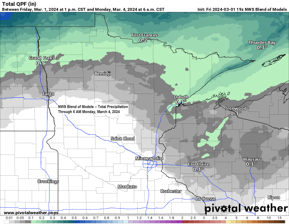
This system will be quite strong, but the best forcing will likely pass northwest of our area with our only shot at getting some rain coming with an approaching cold front Sunday afternoon into Sunday evening, but this rain will likely be scattered in coverage so not everyone will get wet on Sunday, and locations that do get some rain likely won’t be getting much with rain totals ranging from around 0.05 inches to 0.25 inches the way it looks now.
500mb analysis from late Friday afternoon.

Will likely see quite a temperature contrast once again on Sunday with temperatures in the teens and 20s in the northern Rockies to the 70s in much of the Midwest.

NAM 3km model simulated radar forecast valid 6 AM Sunday to Midnight Monday.

All of the snow associated with this weekend’s storm will mostly fall in southern Canada where significant amounts of snow and strong winds are expected. Lighter amounts of snow are expected farther south in parts of North Dakota into extreme northwest Minnesota Sunday-early Monday morning.

Record warmth in the Northland today, March 1st, 2024.
- Ashland, WI: 57 (old record 53 set in 1993)
- Duluth, MN: 54 (old record 51 set in 1883/141 years ago)
- International Falls, MN: 51 (old record 50 set in 1993)
Note: Normal highs in our area on March 1st range from the upper 20s to lower 30s.
Thanks for reading!
Tim
Leave a Reply