5:23 PM Friday, March 22, 2024
A messy spring storm is forecast to impact the Northland late this weekend/early next week.
This storm will likely bring snow and wind to the Northland Sunday into Monday followed by some rain, snow and areas of freezing rain Monday night into Tuesday. Some of the precipitation could be heavy at times especially Sunday night into Monday night.
Gusty northeast winds are likely Sunday afternoon through Monday night with the strongest winds occurring near Lake Superior (gusts 30 to 50 mph). The strong winds combined with falling snow will lead to considerable amounts of blowing snow especially near Lake Superior Sunday night through Monday night.
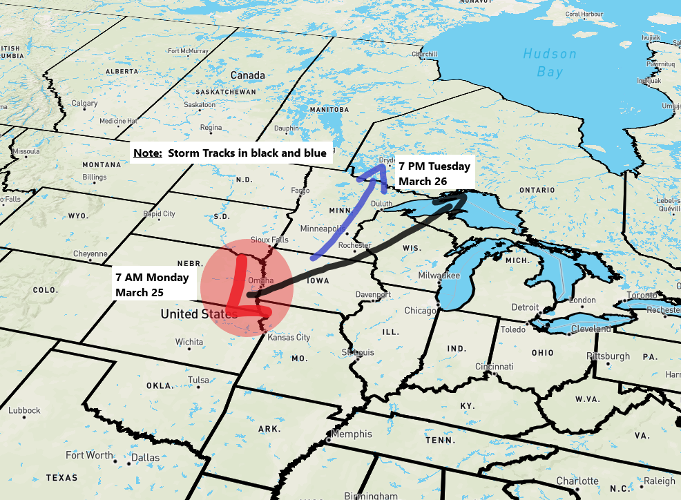
An area of low pressure is forecast to move into western Kansas Sunday evening and reach eastern Nebraska Monday morning. This low is then expected to track into northern Iowa by Monday evening. Beyond Monday evening the storm track is still somewhat uncertain today, but the range is from the low moving almost due north out of southern Minnesota as the low passes near Duluth Tuesday morning to the low passing through west central/northeast Wisconsin and western Upper Michigan Tuesday night.
ARRIVAL TIME OF THE SNOW THIS WEEKEND
With such a strong high sitting north of Lake Superior this will feed dry air south into our area on Sunday, but eventually the low approaching from the south will win out and cause precipitation to reach the Northland, but how soon this occurs is uncertain as computer models tend to be too fast in bringing precipitation north into our area in this type of setup.

We should see snow slowly develop/overspread the Northland from south to north on Sunday, but it may take until the afternoon or even as late as Sunday evening for this to occur.
Duluth area: Snow gradually develops during the day Sunday with some heavier snow possible especially later Sunday afternoon and or Sunday night.
NAM 3km model simulated radar forecast valid from 7 AM Sunday to 1 AM Monday (snow in blue colors)

Here’s my preliminary snowfall forecast valid Sunday afternoon through early Tuesday morning.
- The amount of dry air could cut into snow totals especially in northern Minnesota.
- Mixing/rain issues possible Monday afternoon/night in northwest Wisconsin to possibly as far west as eastern Minnesota, Duluth and the North Shore which could lead to lower snowfall totals.
- More than 12 inches of snow is possible especially along the North Shore of Lake Superior where east to northeast winds will likely produce some terrain enhanced snowfall Sunday night into Monday.
Adjustments to this forecast are likely over the next 24 hours or so with changes to snowfall gradients and snowfall amounts likely.

Winter Storm Watch covers the entire Northland from Sunday morning through Tuesday morning. This watch will likely be upgraded to a winter storm warning or winter weather advisory over the next 24 hours.

FREEZING RAIN/ICE POTENTIAL
There continues to be a chance for some freezing rain in parts of northeast and east central Minnesota and in far northern Wisconsin mainly from late Monday afternoon through Tuesday morning.
European model total ice through 1 PM Tuesday.

STRONG WINDS
A tight pressure gradient will develop this weekend between strong high pressure >1030mb over central/eastern Canada and a strong area of low pressure <990mb over the central Plains, this setup will lead to a period of gusty northeast winds near Lake Superior including in Duluth beginning on Sunday and continuing through about Tuesday morning. The strongest winds are expected Monday/Monday night with wind gusts from 30 to 50 mph possible.
European model wind gust forecast valid 7 AM Sunday to 7 AM Tuesday.

Thanks for reading!
Tim
Leave a Reply