6:12 PM Saturday, March 23, 2024
A major winter/spring storm will impact the Northland over the next few days.
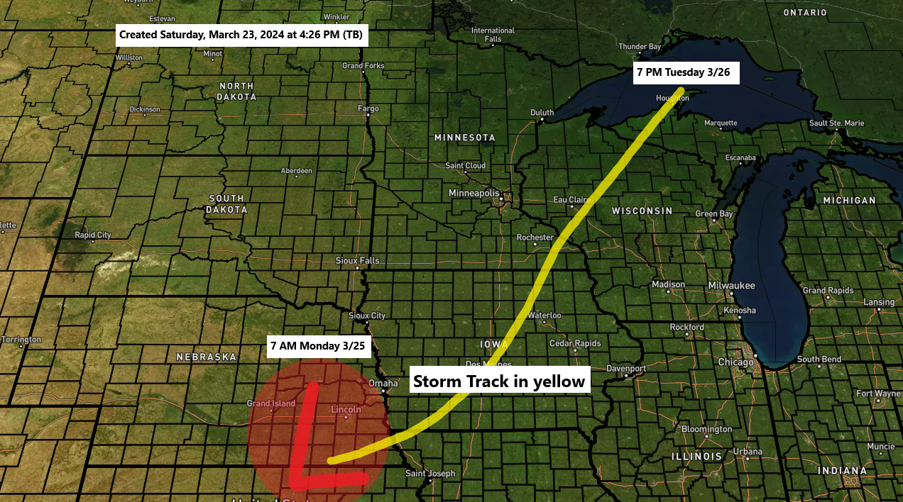
There’s been some notable trends in the computer models today especially in the Euro model as the Euro has shifted the storm track more to the east and more in line with what the GFS model has been showing for a few days now. With this eastern shift in the storm track, this lessens the chance that will see the snow change to rain in Duluth Monday night, but we could still see the snow changeover to some freezing rain for a time Monday night/early Tuesday morning as temperatures aloft warm to around 0C but if temperatures near the surface remain around 30 to 32 degrees, then any rain that falls would freeze on contact Monday night.
Chances for the snow to change to rain are higher still in northwest Wisconsin as that area should see temperatures warm enough Monday afternoon allowing the snow to change to rain at that time, and that rain threat lingers into Monday night in most of northwest Wisconsin.
The uncertainty or one of the uncertainties in the forecast is how far west/north does the warmer air or temperatures above 0C at 850mb get Monday night as locations that warm above 0C at 850mb will see rain. But if surface temps stay at or below freezing, then this rain would turn to freezing rain.
Snow will fall where 850mb temperatures are colder than 0C.

Timing of the snow for Duluth: Light snow begins Sunday morning between 5-8 AM. Snow is expected to become heavier mid to late Sunday afternoon with snow, heavy at times Sunday night into the day on Monday. Note: Snowfall rates of up to 1″/hour are possible during the peak of this storm Sunday night into Monday. Snow could change to freezing rain or rain Monday evening through early Tuesday morning with precipitation turning back over to snow during the day Tuesday.
NAM 3km model simulated radar forecast valid 1 AM tonight to 7 PM Monday.

Here’s my updated snowfall forecast as of 5:55 PM Saturday.
- 11 to 15 inches of snow for Duluth.
- Lesser amounts of snow in far northern Minnesota due to possible dry air cutting into snow totals the farther north you go.
- Mixing/rain issues continue for all of northwest Wisconsin, and also for eastern Minnesota, and possibly as far north as Duluth and the North Shore Monday afternoon through Tuesday morning.
Note: Higher snow totals in excess of 15 inches are possible especially along the North Shore of Lake Superior due to possible lake/terrain enhanced snowfall Sunday evening through Monday.

-Blizzard Warning in effect for the North Shore of Lake Superior Sunday afternoon through Tuesday afternoon.
-Winter Storm Warning in effect for the rest of northeast Minnesota and far northwest Wisconsin Sunday through Tuesday.

FREEZING RAIN/ICE ACCUMULATION POTENTIAL
A changeover from snow to freezing rain is possible Monday night into Tuesday morning over parts of northeast and east central Minnesota into far northwest Wisconsin.
Here are a few ice accumulation forecasts from the computer models.
Euro model
Duluth’s total: 0.25 inches of ice accumulation.

Eps model
Duluth’s total: A range from 0 inches to 0.13 inches of ice accumulation.

NWS Blend of Models
Duluth’s total: 0.02″ of ice accumulation.

GUSTY WINDS
Northeast winds will be increasing during the day Sunday and will likely be strongest from Monday into early Tuesday morning with wind gusts from 25 to 40 mph with higher gusts possible especially near Lake Superior. The strong winds combined with falling snow will lead to areas of blowing snow with whiteout or near whiteout conditions possible at times mainly near Lake Superior from Sunday evening through Monday.
NAM 3km model wind gust forecast valid 7 AM Sunday to 1 AM Tuesday.

Thanks for reading!
Tim
Leave a Reply