6:03 PM Wednesday, May 22, 2024
The active weather pattern is expected to persist at least into the early part of next week.
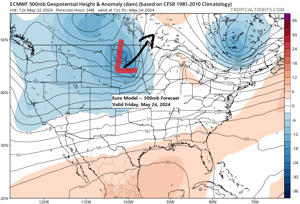
A short respite from the rain and strong winds is expected on Thursday, but it will be fleeting as a new system is predicted to move northeast from the western High Plains into the northern Plains and upper Midwest by Friday.
The upcoming weather system is expected to bring additional rain to the Northland area on Friday, though the anticipated rainfall amounts seem less substantial than those of the previous system that affected the region.
Heading into the holiday weekend, the weather remains dynamic, with another system passing over the Rockies. This system is expected to shift towards the central Plains and Midwest from Sunday to Monday. The current storm track is positioned further south than recent systems, which could result in the Northland area avoiding additional rainfall this weekend and into the early part of next week.

Note: The likelihood of rain in the Duluth area is highest during the daytime on Friday.
Scattered showers and occasional thunderstorms may occur Thursday night across the northwest and northern regions of Minnesota, but current projections suggest this precipitation will remain northwest of Duluth.
NAM 3km model simulated radar forecast valid 7 PM Thursday to 7 PM Friday.

Rainfall in the Northland on Friday could range from approximately a quarter inch to more than three quarters of an inch.

It appears that a significant temperature gradient will develop on Friday, with temperatures ranging from the low to mid-40s near Lake Superior, including the Twin Ports area, while regions farther south may experience temperatures in the 60s to around 70 degrees in the afternoon.

Duluth will experience a brief respite from the strong winds on Thursday, but this will be short-lived as another wave of gusty northeast winds is forecasted to arrive by Thursday evening. These persistent winds are expected to continue into Friday, with gusts ranging from 25 to 35 mph.
NAM 3km model wind gust forecast valid 7 PM Thursday to 7 PM Friday.

Our active spring weather pattern persists today with multiple systems in play, two north of Minnesota and another over the Pacific Northwest. It’s this latter system that is expected to impact the Northland area on Friday.

The storm that delivered widespread rain to the Northland in the last 24 hours has now shifted over Lake Nipigon in Ontario, Canada. Today, it is a profound system with its central pressure having dropped to 989mb this afternoon.
A strong pressure gradient to the southwest of this low-pressure system resulted in powerful winds across the Northland today, with wind gusts reaching up to 55 mph in some areas.
Peak wind gusts from Wednesday, May 22, 2024
Duluth Airport: 55 mph
Ashland, WI: 46 mph
Brainerd, MN: 43 mph
International Falls, MN: 37 mph
Hibbing, MN: 36 mph

Northern Minnesota, extending into the Arrowhead region, will continue to experience some rain and drizzle late this afternoon. However, the rain is expected to cease by late evening.
Also, take note of the blue hues in Canada; indeed, that indicates snow!
Radar loop ends 5:50 PM Wednesday, May 22, 2024.
Here’s a look at this strong spring storm north of Minnesota today via water vapor imagery.
Goes-16 water vapor loop ending 4:20 PM CT, Wednesday, May 22, 2024.

On Tuesday, there were well over 500 reports of severe weather, primarily concentrated in the Midwest.
Nearly 30 tornado reports (red)
Around 400 reports of damaging winds (blue)
Around 150 reports of large hail (green)
Note: 3 tornado reports in central Wisconsin Tuesday evening.
- Unity, Wisconsin (EF 1 tornado)
- 4 miles west-southwest of Poniatowski, Wisconsin (EF 1 tornado). 90 mph max wind speeds.

Thanks for reading!
Tim
Leave a Reply