1:30 PM Wednesday, June 12, 2024
Scattered to numerous severe thunderstorms may occur across a broad area of northeast Minnesota and far northwest Wisconsin later this afternoon and into the evening.
The primary window for potential severe thunderstorms to traverse the Northland region is approximately between 4 PM and 11 PM today.
It is likely that at least one tornado or severe thunderstorm watch will be issued for much of the Northland by later this afternoon.
The Storm Prediction Center (SPC) has escalated the severe weather risk to a level 3 out of 5, indicated by the orange area on the map, for late this afternoon and evening.

An elevated to slight risk of severe thunderstorms is forecasted for the entire Northland area through this evening. Here are the implications of these risk levels.

The shaded area on the map indicates a potential for significant hail, exceeding 2 inches in diameter, expected later this afternoon into the early evening.

Hail size chart

Severe thunderstorms later this afternoon or evening could bring damaging winds, with gusts potentially reaching 60 to 70 mph. The highest risk for these damaging winds is indicated by the red area on the accompanying map.

Late this afternoon into early evening, there is a possibility of a few tornadoes, particularly in the brown shaded area indicated on the map below.

HRRR model simulated radar forecast through Midnight tonight.

Mostly sunny conditions across north central Minnesota will persist, contributing to increasing atmospheric instability throughout the afternoon.
Visible satellite loop from Wednesday, June 12, 2024, loop time ends 12:56 PM CT.

A substantial amount of warm air is traveling north-east from western Minnesota this afternoon, with temperatures soaring into the 80s.

The Northland is poised for severe weather later today, supported by robust jet dynamics and mid-level winds reaching strengths of 50 to 60 knots.

Additionally, a robust upper-level jet is advancing eastward from the northern Plains this afternoon, with wind speeds nearing 100 knots at the 300mb level.

Steep mid-level lapse rates up to 7.5 C/km are approaching the Northland this afternoon, which could contribute to the development of large hail in several storms later today.

Today’s wind shear, with 0-6 KM shear in the 50 to 60 knot range, is highly conducive to severe weather conditions.

One factor that may reduce the overall tornado potential is the surface to 850mb wind direction, which is predominantly from the southwest this afternoon. However, if the surface winds shift to a more southerly direction, there could be an increased risk of tornadoes, especially if the storms stay discrete later in the day.
While winds increase with altitude (speed shear), this leads to the possibility of rotating supercell thunderstorms, which can produce large to very large hail and damaging winds.

Winds change direction with altitude, showing a west to northwest flow at 500mb, which shifts to the southwest closer to the surface. This veering of wind with height is conducive to the formation of rotating supercell storms later today.

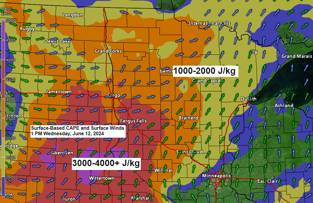
Significant instability (CAPE) is advancing north/east from the eastern Dakotas and western Minnesota this afternoon, with values reaching as high as 3000-4000 J/kg.

Finally, there is a significant amount of rich, low-level moisture with dew points ranging from the mid-60s to around 70 in western Minnesota. This air mass is expected to keep moving northeast into the Northland throughout the afternoon.

The risk of flash flooding remains low due to the rapid movement of the storms expected later today or this evening. However, there is still a possibility of intense downpours that could result in a swift 1 to 2 inches of rainfall in certain areas of the Northland.

Thanks for reading!
Tim
Leave a Reply