5:12 PM Sunday, January 12, 2025
The widespread light to moderate snow event we saw in the Northland last night was more of an anomaly than anything else, given the way this winter has been in this area. It looks like we go right back into a pretty snowless pattern for the next 7 to 10 days or so, but that’s not to say we won’t see the occasional clipper bring a skiff of snow. However, the pattern ahead does not support any major snow events in our area anytime soon.
Updated snowfall stats for Duluth, Minnesota as of 4 PM January 12, 2025.
-Month to date: 8.0 inches; Departure +1.2 inches above normal
-Seasonal total for 2024-2025: 21.6 inches; Departure -20.8 inches below normal
-Current snow depth: 9 inches (NWS location)
Several shots of arctic air are in the forecast over the next 10 days or so.
The first blast of arctic air occurs tonight through Wednesday morning, with lows ranging from around 5 below to 20 below zero in northeast Minnesota and northwest Wisconsin. Highs on Monday will range from around 5 below to 5 above zero in the Northland, with highs Tuesday in the single digits to lower teens above zero.
Temperatures moderate mid to late week; in fact, we could see temperatures approach the freezing mark in parts of the Northland on Thursday and Friday. But more bitterly cold air is set to return next weekend and beyond; more on that below.
Wind chill temperatures are forecast to range from around 15 below to 30 below in the Northland tonight and Monday, with the lowest wind chills expected overnight through about mid-morning on Monday.
HRRR model wind chill temperature forecast through 6 PM Monday.

Cold Weather Advisory in effect late tonight into Monday morning for the areas in blue on the map.

Snow showers and flurries will linger tonight and Monday across parts of the Northland, especially over the Arrowhead, and also along the South Shore of Lake Superior including the Bayfield Peninsula, where some lake/gravity-effect snow will occur.
HRRR model simulated radar forecast through Midnight Tuesday.

HRRR model total snowfall through late Monday night.

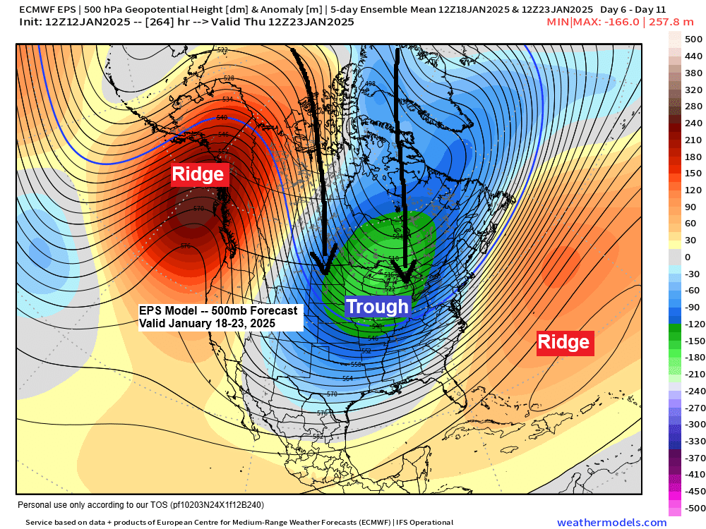
Several lobes or pieces of the polar vortex (gray and white colors on the loop) could drop south/east through the northern Plains, upper Midwest, and Great Lakes late next weekend into the early to middle part of the following week.
GFS model forecast valid January 18-22, 2025.

An early look at the surface map for next Monday, January 20th, 2025, shows a very impressive area of high pressure nearing 1060 mb/31.27″ centered over central Montana per Euro model forecast.
With the high over the northern Rockies, this puts the Northland in a frigid northerly flow early next week.

The extent of below-normal temperatures being advertised by the ensemble models is simply impressive, with the blue and purple colors representing below-normal temperatures.
EPS model

GEFS model

Thanks for reading!
Leave a Reply