Winter returns strongly, and so does Lake Superior. It’s been months since a northeasterly wind event like this one, so welcome back, Lake Superior; it’s been a while.
Back-to-back days with peak wind gusts of over 60 mph in Duluth, with a peak gust of 64 mph on Tuesday followed by a peak gust of 66 mph on Wednesday; that’s pretty impressive. Hurricane-force winds are 74 mph or greater, so yeah, we got a little close there early this morning.
From a forecaster’s perspective, this storm has unfolded as expected. The timing of the precipitation, when the heaviest snowfall rates would occur, and the areas of greatest impact aligned well with predictions. I first noted the potential for blizzard conditions along the North Shore in a Facebook post on Saturday, February 14th, a few days ahead of time. Consistent computer model guidance helped, despite some variations in storm track; the overall outlook indicated a significant storm, supported by ensemble data.
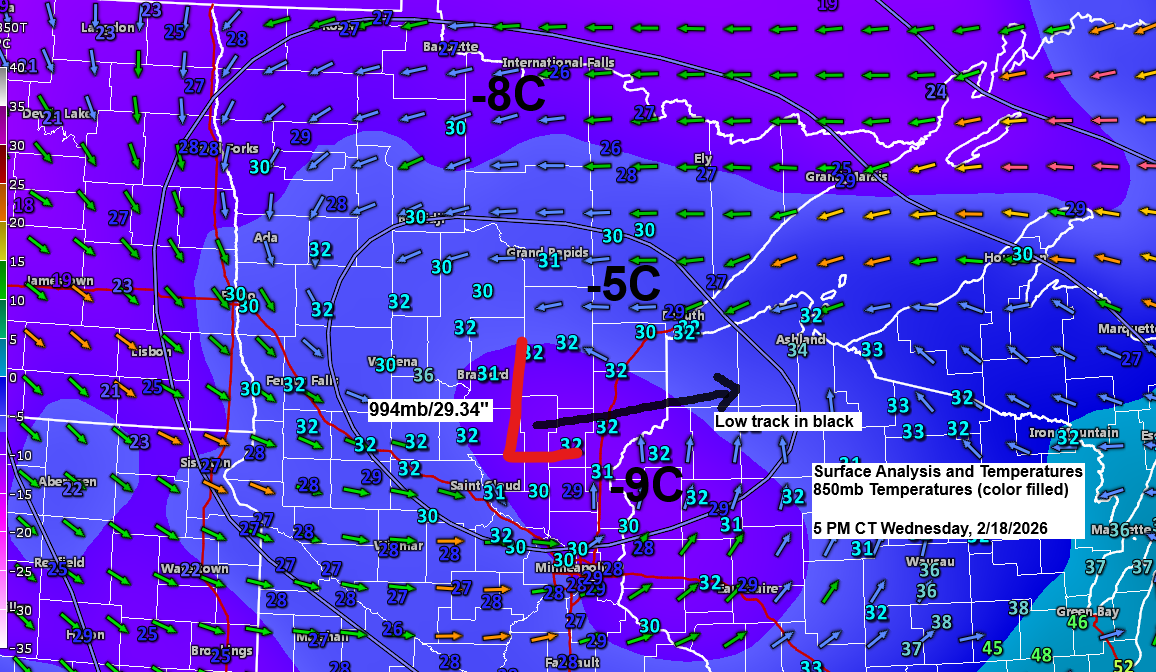
Low pressure continues to weaken late this afternoon as it crawls into eastern Minnesota with a central pressure of 994 mb or 29.34 inches; earlier today, the pressure was down around 983 mb. This low will continue to inch slowly east as it tracks across northern Wisconsin late tonight and Thursday.
This storm will continue to produce areas of snow tonight and Thursday, with the heaviest snowfall and greatest accumulations favoring the North Shore of Lake Superior. Gusty winds will also continue, which will lead to more blowing snow and occasional whiteout or blizzard conditions tonight through Thursday morning along the North Shore of Lake Superior.
…Additional Snowfall through 6 AM Thursday…
About 1 to 3 inches for Duluth and the Bayfield Peninsula, with 6 to 12 inches in the far northeast Arrowhead along the North Shore, and about 3 to 5 inches along most of the rest of the North Shore.
Areas of freezing drizzle are also likely tonight, with a thin coating of ice accumulation in parts of the Northland.

NAM 3km model simulated radar forecast through 7 PM Thursday.

…Winter Weather Alerts…
-Blizzard warning continues along the North Shore of Lake Superior in northeast Minnesota until 12 PM Thursday.
-Winter Storm Warnings and Winter Weather Advisories continue for other parts of northeast Minnesota and northwest Wisconsin through Thursday morning.

…Power Outage Update…
70 outages affecting about 610 Minnesota Power customers as of early Wednesday evening; this number is down by quite a bit from earlier today.

…Record precipitation and snowfall in Duluth, Minnesota today…
Snowfall total for February 18, 2026, up to 4 PM: 5.5 inches, which is a new record for the date, beating the old record of 4.2 inches set in 1909.
0.59 inches of precipitation have fallen so far today in Duluth, which sets a new daily precipitation record for February 18. The old record for the date was 0.40 inches, also set in 1909.
The official snowfall storm total in Duluth up to 4 PM on February 18 is 7.3 inches, with a precipitation total of 0.71 inches. This results in a snow-to-liquid ratio of about 10:1. So, it’s definitely a wetter snow compared to the dry/fluffy snow we’ve seen with many systems this winter.
This is about as beautiful a water vapor loop as you’ll see as our winter storm continues to impact portions of the upper Midwest and western Great Lakes this afternoon.
Goes-19 water vapor loop ending 5:06 PM CT Wednesday, February 18, 2026.

…Snow chances return Friday?…
Snow chances are currently low, but a second low will move northeast from the central Plains from Thursday to Friday. There is uncertainty about how far north/west the moisture and snow might reach. Some models predict snow in parts of the Northland from Friday into the weekend, while others suggest the snow will stay farther to the east.

Leave a Reply