Category: winter weather advisory
-
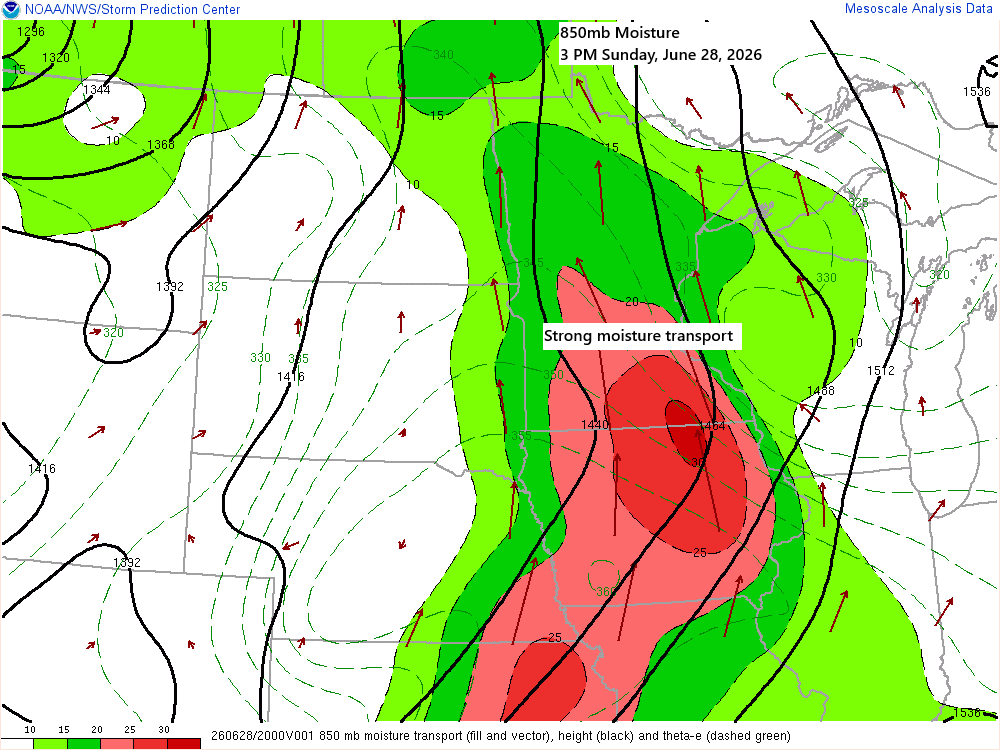
Northland Forecast: Muggy Monday, Storm Chances & Late‑June Snow Out West
A strong southerly low-level jet will keep pushing plenty of moisture north into our area tonight. This afternoon’s surface map shows two boundaries: one behaving more like a moisture gradient front, with dew points climbing into the 70s to the south and sitting in the 50s and low 60s to…
-
Northland Hit by Strong Northwest Winds; Much Cooler Days Ahead
A steady northwest flow this week will keep the Northland mostly dry, though a few brief rain or snow showers are possible, with little to no accumulation expected. Temperatures will run below normal for the next several days, with the coldest stretch from Tuesday through Thursday, bringing highs in the…
-
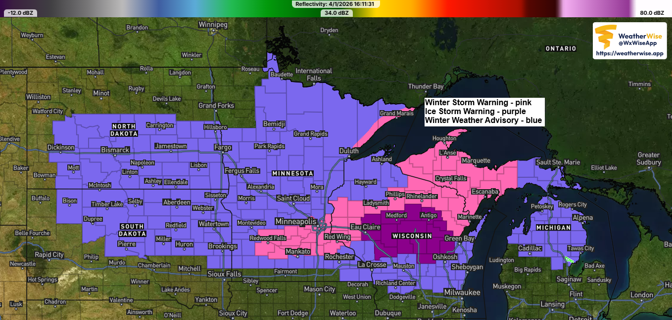
Winter Storm Update: Revised Snowfall Forecast as of 5 PM, Wednesday, April 1, 2026.
A messy winter storm will hit the Northland tonight and last through Thursday evening, with the heaviest precipitation expected from Thursday afternoon until around mid-evening Thursday. Duluth area: Snow will start to develop tonight, with up to an inch of accumulation possible by 8 AM Thursday. Snow will continue through…
-
Winter Weather Advisory: Areas of Snow and Ice Expected
Two posts will be coming out today as multiple systems are set to impact the Northland this week. The first post highlights a weather system expected late tonight into Tuesday morning, bringing the chance of snow, rain, and freezing rain. Because of this, a winter weather advisory is in effect…
-
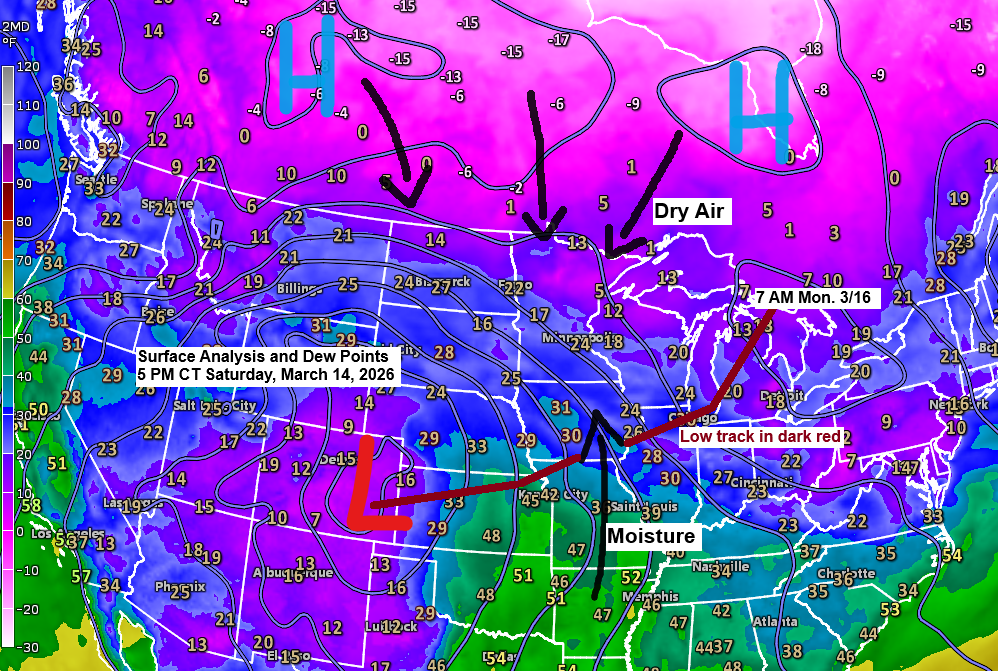
Winter Storm Update: Updated snowfall forecast as of 6 PM on Saturday, March 14, 2026.
A major winter storm is expected to sweep across much of the northern Plains, upper Midwest, and Great Lakes in the coming days, but predicting its impact is tricky, especially here in the Northland. High pressure sits to our north, while low pressure over eastern Colorado moves east-northeast toward Chicago,…
-
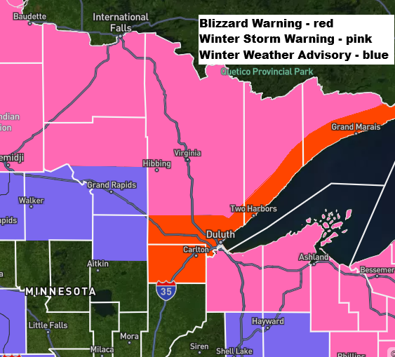
Blizzard conditions are expected on the North Shore from tonight through Friday morning.
Note: For a storm to qualify as a blizzard, three conditions must occur for at least three straight hours: winds over 35 mph, visibility under a quarter mile, and falling or blowing snow. …Blizzard conditions along the North Shore… East to northeast winds will keep picking up tonight, with gusts…
-

An active weather pattern
The weather’s been pretty active lately, and it doesn’t look like it’s calming down anytime soon. Today, a pair of low-pressure systems stretch from eastern Colorado to northern Missouri, with a strong warm front cutting across north-central Illinois, creating a sharp temperature contrast—from the upper 30s in Chicago to around…