A steady northwest flow this week will keep the Northland mostly dry, though a few brief rain or snow showers are possible, with little to no accumulation expected.
Temperatures will run below normal for the next several days, with the coldest stretch from Tuesday through Thursday, bringing highs in the 30s and 40s and lows in the 20s and 30s.
By late week into the weekend, it should warm up a bit, with afternoon highs in the 40s and 50s, and possibly a few spots hitting 60 on Friday. Still, yesterday (Sunday) was likely the warmest day we’ll see here for about the next week.
Forecast models hint at a wetter pattern possibly returning by mid-month, though it’s still a ways off.
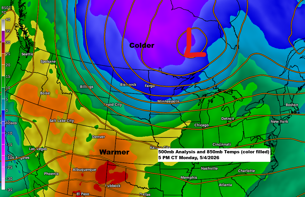
A strong low-pressure system of 983mb, or 29.03 inches, is moving northeast out of central Ontario today. Earlier, a powerful cold front tied to this system swept through the Northland, and now another surge of unseasonably cool air is pushing south from central Canada, driven by strong northwest winds.
This afternoon, in the warm air ahead of today’s cold front, a dust storm has been sweeping through parts of central Illinois, bringing visibility down to nearly zero miles.

Northwest winds have been sweeping across the Northland today, with gusts ranging from 30 to 45 mph.
- Duluth Airport: 49 mph
- Hibbing, MN: 47 mph
- International Falls, MN: 45 mph
- Brainerd, MN: 44 mph
- Ely, MN: 43 mph
- Ashland, WI: 43 mph
- Duluth Sky Harbor Airport: 43 mph

Some rain passed through northern Minnesota earlier today.
- Hog Creek 0.18″
- International Falls 0.16″
- Orr 0.13″
- Cook 0.11″
- Isabella 0.11″
- Ely 0.10″
- Bigfork 0.08″
- Hibbing 0.04″
- Cass Lake 0.03″

A spring snowstorm is headed for parts of Wyoming and Colorado over the next few days, bringing significant snowfall.

Snowfall in the Denver area may reach 6 inches, with 1 to 2 feet possible west of Denver by Wednesday afternoon.
In the Denver area, the average date for the last snowfall of 1 inch or more is April 22, with the latest on record being May 29 in 1975.
If Denver gets 6 or more inches of snow this late in the season, it would be pretty unusual. On average, the last snowfall of 6 inches or more happens around March 7th, with the latest on record being May 25, 1950.

Check out that strong system north and northeast of Maine, hovering over southern Quebec and the Gulf of St. Lawrence, making its way toward Newfoundland today.
Goes-19 water vapor loop ending 5:10 PM CT Monday, May 4, 2026.

Leave a Reply