A fast-moving, narrow band of snow is expected to sweep across parts of the Northland late tonight and linger into early Tuesday morning. It will follow a sharp temperature gradient, with northwest Minnesota seeing temps in the teens, while central and southern Wisconsin enjoyed highs in the 60s to near 70 degrees this afternoon.
It might not feel like snow is coming to Duluth tonight with afternoon temperatures in the 40s, but temperatures will drop enough later for flakes to start falling. Overnight into Tuesday, temperatures are expected to range from the upper 20s to about 31 degrees.

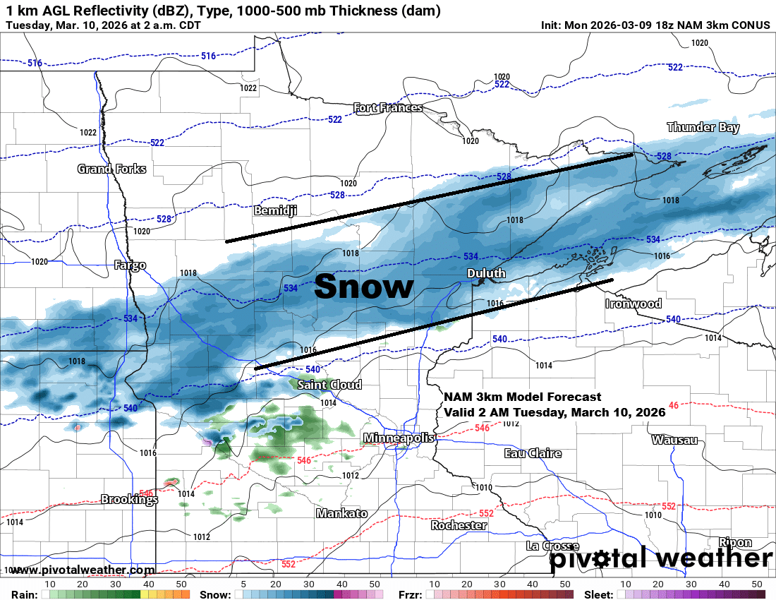
For Duluth: Most of the snow is expected to fall between midnight and about 7 AM on Tuesday, with up to an inch of accumulation. The rest of the day may bring a few flurries and east winds off Lake Superior gusting 15 to 30 mph, but no further accumulation is expected after 7 AM.
NAM 3km model simulated radar forecast through 7 AM Tuesday.

Because tonight’s snow will fall in a fairly narrow band, even slight shifts north or south could determine exactly where the accumulations end up.
Under the main part of the snow band, we might get about 1 to 2 inches of snow by 7 AM Tuesday, with smaller amounts to the north and south.

Another wave of snow is expected late Tuesday afternoon, lasting into early Wednesday morning, impacting much of northwest Wisconsin and east central Minnesota, and possibly reaching as far north as Duluth. This round could add another 1 to 2 inches of snow Tuesday night.
NAM 3km model simulated radar forecast valid 4 PM Tuesday to 12 PM Wednesday.

The two active branches of the jet stream are clearly visible on today’s water vapor imagery.
The northern branch is bringing some moisture east from the Pacific, while the southern branch of the jet stream has a strong mid- and upper-level low over the Baja region, sending plenty of subtropical moisture northeast ahead of the system.
If this system had phased, we’d probably be dealing with quite a winter storm in the upper Midwest over the next few days. But since there won’t be much phasing between the two branches of the jet stream, it’s looking like mostly light snow events in parts of the Northland through Wednesday morning.
Goes-19 water vapor loop ending 4 PM CT Monday, March 9, 2026.
On Tuesday, the threat of severe thunderstorms rises to an enhanced risk, or level 3 out of 5, with two main regions affected. One stretches from northeast Missouri through central Illinois into northern Indiana, while the other covers parts of west and central Texas.
All severe hazards are in play for Tuesday, including large hail, damaging winds, and tornadoes, with a couple of strong tornadoes (EF-2+) possible, especially in the enhanced risk zones.

Outlook for Wednesday

…Looking Ahead…
The weather pattern remains active, with the possibility of more snow in northeast Minnesota and northwest Wisconsin late this week and into the weekend. Snow amounts are still to be determined.
Leave a Reply