Latest snowfall numbers for Duluth following the past two snow events.
The seasonal total for 2025-2026 has reached 61.2 inches, which is 11.8 inches below to date. We’re just 29 inches short of our average of 90.2 inches and have definitely made some progress lately. So far, Duluth has seen about 17 inches more snow this season compared to the same point last year, as of March 11th.
Note: Over the last three days, Duluth has received 6.1 inches of snow and 0.30 inches of precipitation, resulting in a snowfall ratio of 20:1.
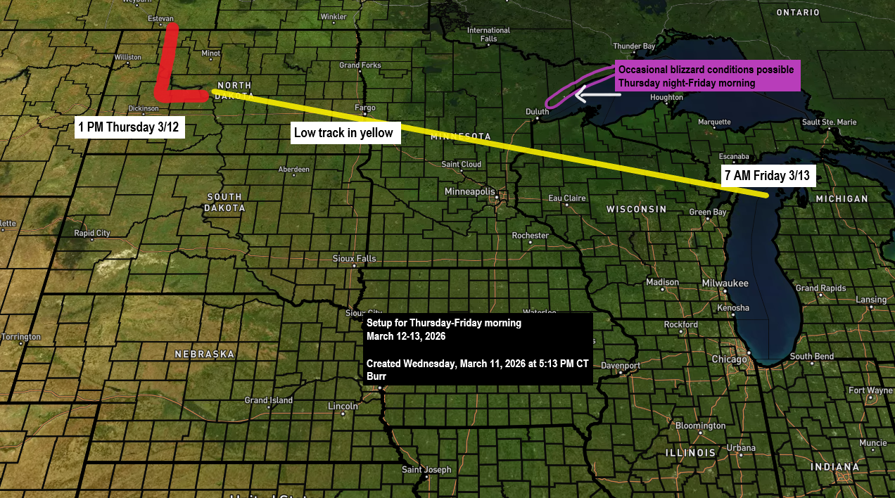
…The next winter storm is set to arrive later Thursday afternoon…
A fast-moving winter storm will sweep across the Northland starting mid to late Thursday afternoon and push east by Friday afternoon. This clipper system will bring another round of accumulating snow to northeast Minnesota and northwest Wisconsin, along with gusty winds that could cause blowing snow Thursday night into Friday. At times, blizzard conditions may develop along the North Shore of Lake Superior from Thursday night into Friday morning.
…Winter Weather Headlines…
Several winter weather alerts are in effect across the Northland from Thursday afternoon until Friday morning.


For Duluth: Thursday morning into early afternoon should stay dry, with a chance for some sunshine. Snow is expected to roll in between 3-5 PM, with the heaviest snowfall in Duluth—about 0.5 to 1 inch per hour—likely hitting late in the afternoon or evening. Light snow will probably linger overnight and into Friday morning. East winds will pick up Thursday afternoon with gusts of 15 to 30 mph, continuing into the evening. By late Thursday night into Friday, winds will shift to the northwest with stronger gusts of 20 to 40 mph. Patchy blowing snow is expected Thursday night and may linger into Friday. Temperatures from Thursday afternoon into the night are expected to range between 28 and 32 degrees, so the snow will likely be wetter and denser than the fluffier snow we had Tuesday night.
Euro model simulated radar forecast valid 7 AM Thursday to 1 PM Friday.

Parts of the Northland could see heavy snowfall at a rate of 1 to 2 inches per hour from late Thursday afternoon into the night, driven by a strong mid- and upper-level low moving southeast from the northern Plains. This system is set to bring significant lift as it moves through the region later Thursday.
RGEM model 500mb forecast valid 4 PM Thursday to 7 AM Friday.

Here’s my snowfall forecast ending 1 PM Friday.
The highest snow totals from this storm are expected along the North Shore of Lake Superior, where lake and terrain effects should boost snowfall as east winds move across the lake Thursday night. Farther south, snowfall amounts are expected to be lower.
Duluth area: Expect about 3 to 5 inches of snow, but with the 5-8 inch zone nearby, even a slight southward shift in the low could push Duluth into that higher range.

…High Wind Alerts…
Areas under a high wind alert can expect gusts between 40 and 65 mph from Thursday into Friday morning, as strong winds spread southeast behind a low-pressure system.

Euro model wind gust forecast valid 7 AM Thursday to 7 PM Friday.

…Weekend Winter Storm Threat…
The odds of a major winter storm hitting much of the Northland, including Duluth, are dropping for this weekend. For several days, the Euro model had been predicting a strong storm from Saturday night into Sunday, while the GFS model kept it farther south and away from our area. In the last two runs, the Euro model has shifted toward the southern track favored by the GFS. If this trend continues over the next few days, northeast Minnesota and northwest Wisconsin likely won’t see much snow Saturday night into Sunday. Still, with a few days to go, the system’s path could shift slightly north, so it’s worth keeping an eye on.

Leave a Reply