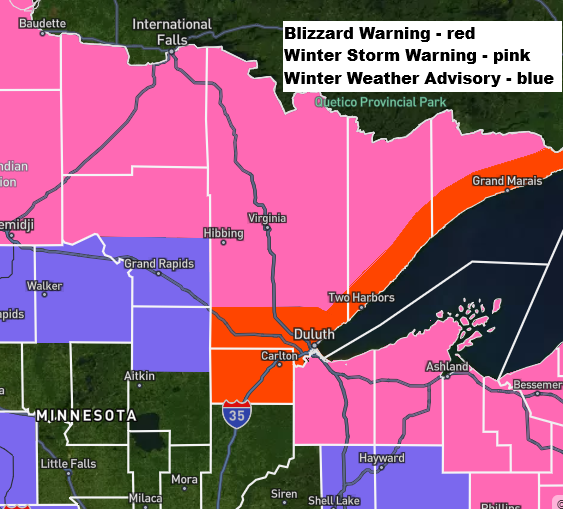
- Blizzard warnings are in effect for the North Shore of Lake Superior, including Duluth, through Friday morning.
- Winter storm warnings and advisories are in place across other parts of the Northland during the same period.
- This will be a quick-hitting but intense winter storm tonight, with snowfall rates reaching 0.5 to 2″/hour (highest along the North Shore)
Note: For a storm to qualify as a blizzard, three conditions must occur for at least three straight hours: winds over 35 mph, visibility under a quarter mile, and falling or blowing snow.

…Blizzard conditions along the North Shore…
East to northeast winds will keep picking up tonight, with gusts hitting 30 to nearly 50 mph. It’ll stay breezy on Friday as winds shift to the northwest, bringing gusts of 20 to 40 mph. Look out for occasional whiteout conditions from falling and blowing snow along the North Shore, including Duluth, tonight into early Friday morning.
Euro model wind gust forecast through 7 PM Friday.

For Duluth: Heavy snow at times tonight will taper to light snow Friday morning, with dry weather returning by the afternoon. East to northeast winds will gust from 25 to nearly 50 mph tonight, shifting to north-northwest with gusts of 20-40 mph from early Friday morning through mid-afternoon. Occasional whiteout or near-whiteout conditions are expected tonight. Temperatures will hold steady between 27 and 31 degrees from tonight through Friday.
NAM 3km model simulated radar forecast through 1 PM Friday.

Here’s my updated snowfall forecast through Noon Friday.
Twin Ports area: Anywhere from 6 to 10 inches of snow.
Along the North Shore, we might see anywhere from 10 to 14 inches of snow.
Much of the rest of the Northland can expect 3 to 6 inches of snow with locally higher amounts, along with 1 to 3 inches in the far southern areas.

…Storm Setup…
Low pressure was moving into eastern North Dakota late this afternoon and will continue to track southeast or east-southeast through the night as it heads toward Green Bay, Wisconsin, by 7 AM Friday. The low will deepen further, peaking at between 984-988 mb late tonight and Friday.
With the low tracking farther south, the cold air will stay locked in over Duluth, so we can expect all snow tonight with no mixed precipitation. Plus, with the low dropping farther south, there’s little chance of a dry slot pushing far enough north to cut off the snow in Duluth tonight.

An upper trough over the northern Plains will drop southeast across the Northland tonight, bringing stronger lift in the atmosphere and periods of heavy snow. Snowfall rates of 0.5 to 1.5 inches per hour are expected in some areas, with the heaviest along the North Shore, where rates could hit 1 to 2+ inches per hour for several hours.

Goes-19 water vapor loop ending 5:30 PM CT Thursday, March 12, 2026.

…High Wind Alerts…
Tonight’s storm will bring strong winds across the northern Plains, upper Midwest, and Great Lakes, with areas southwest of the low’s path experiencing gusts from 40 to nearly 70 mph through Friday morning.
Today, reports have come in of wind gusts exceeding 80 mph in western South Dakota.


Leave a Reply