A major winter storm is expected to sweep across much of the northern Plains, upper Midwest, and Great Lakes in the coming days, but predicting its impact is tricky, especially here in the Northland.
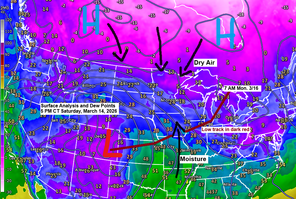
High pressure sits to our north, while low pressure over eastern Colorado moves east-northeast toward Chicago, IL by 7 PM Sunday, then reaches northern Lower Michigan by 7 AM Monday.
A high-pressure system to our north will send dry air south into the Northland, while moisture moves northward. How far that moisture and snow reach depends on which computer model you check.
For Duluth, based on similar past setups, the drier models usually perform better. That said, my confidence in this system isn’t very high and hasn’t been for a while, given the varying solutions the computer models are producing.
Here’s my updated snowfall forecast as of late Saturday afternoon for this event.
Duluth area: Expect between 1 and 4 inches of snow, with only a trace to 1 inch farther north.
Snowfall gradients are pretty sharp across the Northland with this storm, and generally, the farther south or southeast you go from Duluth, the higher the expected snow totals. Areas from Spooner to Shell Lake to Hayward to Hurley are forecast to see anywhere from 14 to over 20 inches of snow.
From Sandstone to Solon Springs, snowfall could range between 7 and 10 inches, with about 4 to 7 inches expected from Moose Lake to just south of Superior. Brainerd, Aitkin, and Cloquet may see 2 to 4 inches.

For Duluth: Snow will gradually develop tonight, between 10 PM and 1 AM. Snow will continue into Sunday morning, with some light snow lingering Sunday afternoon/evening.
Snow in far eastern Minnesota and northwest Wisconsin will likely continue until late Sunday night or early Monday morning, gradually tapering off from northwest to southeast.
Euro model simulated radar forecast through 7 AM Monday.

- A blizzard warning is in effect for all of northwest Wisconsin and Pine County in eastern Minnesota, including Hinckley and Pine City, from late tonight through Monday morning.
- Expect occasional blizzard or near-blizzard conditions, with periods of whiteout conditions across much of northwest Wisconsin from late tonight through early Monday morning.
- Snowfall in parts of northwest Wisconsin could reach rates of 0.5 to 1.5 inches per hour late tonight and continue into Sunday.
- Winter Storm Warnings and Winter Weather Advisories are in place for parts of northeast and east-central Minnesota, starting late this evening and continuing through Sunday evening.

Parts of seven states—South Dakota, Nebraska, Iowa, Illinois, Minnesota, Wisconsin, and upper Michigan—are under blizzard warnings through Sunday night, with blizzard warnings lingering into Monday the farther east you go.


…Strong Winds…
Winds will pick up in northeast Minnesota and northwest Wisconsin early Sunday morning and stay strong through Monday. They’ll blow in from the northeast at first, shift to the north during the day Sunday, and then move to the north or northwest Sunday night into Monday. Gusts of 15 to 30 mph are expected, with stronger gusts of 30 to 45 mph likely in northwest Wisconsin and along the North Shore in northeast Minnesota.
Expect areas of blowing and drifting snow in parts of the Northland due to these strong winds Sunday into Monday morning.
Euro model wind gust forecast through 7 PM Monday.

…Upper Levels…
This afternoon’s water vapor imagery clearly shows the storm taking shape, with a trough digging southeast across the Rockies and abundant moisture streaming northeast ahead of it.
Goes-19 water vapor loop ending 5:45 PM CT Saturday, March 14, 2026.

The mid and upper-level trough will significantly amplify and strengthen on Sunday, as a closed low forms over the central and eastern Great Lakes from Sunday night into Monday.

…Severe Thunderstorm Potential…
The risk of severe thunderstorms is on the rise for Sunday and Monday, all tied to the same storm sweeping across the upper Midwest.
Sunday brings the highest risk across much of the south-central and southeastern U.S., stretching into the Midwest and Ohio Valley, with a threat of strong tornadoes focused on the Ark-La-Miss and Ohio Valley areas.

On Monday, the risk moves to the eastern seaboard, with the greatest threat spanning from South Carolina to Maryland. A few strong tornadoes are possible, along with damaging winds and perhaps some hail.

Leave a Reply