This second post highlights two possible winter storms that could impact the Northland later this week and into the weekend.
Before getting into the details, let’s see how Duluth measures up in snowfall for the 2025-2026 season through March 30th.
Total: 73.6 inches
We only need another 16.6 inches of snow to reach our average of 90.2 inches, and that’s definitely possible with all of April and even early May still offering chances for snow here. I wouldn’t have thought we had a shot back in mid-February, but things have changed quite a bit since then.
A look at the ten snowiest Aprils ever recorded in Duluth, MN.
1: 50.8 inches (2013)
2: 31.6 inches (1950)
3: 26.3 inches (2014)
4: 24.4 inches (1961)
5: 23.7 inches (1983)
6: 20.4 inches (1972)
7: 19.2 inches (2022)
8: 19.0 inches (1989)
9: 18.5 inches (2018)
10: 18.0 inches (1893)
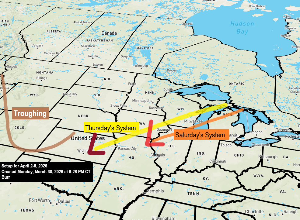
…Late week and weekend Systems…
On Thursday, the first system will bring a surface low over the central Plains moving northeast, while a mid and upper-level trough heads north into the upper Midwest. There are some signs it might try to take on a negative tilt, though current guidance doesn’t show strong signals for that just yet.
Much of northeast Minnesota and northwest Wisconsin can expect snow or a wintry mix of snow, sleet, and freezing rain from Thursday into early Friday morning if the system stays on its current course. However, there’s always a chance the track could shift since it’s still a few days away.
It’s still too early to issue a snowfall forecast for Thursday’s system, but I plan to release one Tuesday afternoon if model guidance stays consistent over the next 24 hours.

Northeast winds gusting from 25 to nearly 50 mph could hit Duluth and areas near Lake Superior starting Wednesday afternoon or evening and lasting through early Friday morning. If snow falls on Thursday, it could cause blowing snow and poor visibility, while freezing rain might lead to isolated power outages. Even without precipitation, the strong winds alone could cause some outages.
Euro model wind gust forecast valid from 7 PM Wednesday to 7 AM Friday.

This weekend’s weather looks a lot like mid to late week, with a strong trough dipping southeast from the Pacific Northwest before swinging northeast toward the Upper Midwest and Great Lakes.
I think the evolution of this weekend’s system is more uncertain compared to the one on Thursday.
The upper trough with a closed low is expected to open up as it moves out of the Rockies, signaling a bit of weakening, though guidance suggests it may strengthen again as it moves across the upper Midwest over the weekend.
Another round of snow, sleet, and freezing rain could hit northeast Minnesota and northwest Wisconsin from the second system sometime between Friday night and early Sunday morning.

Make a one-time donation
Make a monthly donation
Make a yearly donation
Choose an amount
Or enter a custom amount
Thank you for supporting Northland weather blog.
Your contribution is appreciated.
Your contribution is appreciated.
DonateDonate monthlyDonate yearly
Leave a Reply