A messy winter storm will hit the Northland tonight and last through Thursday evening, with the heaviest precipitation expected from Thursday afternoon until around mid-evening Thursday.
- Strong northeast winds of 25 to 45 mph are expected near Lake Superior from tonight through Thursday evening, bringing blowing snow along the North Shore and the chance for occasional brief near-whiteout conditions especially from Thursday afternoon to Thursday evening.
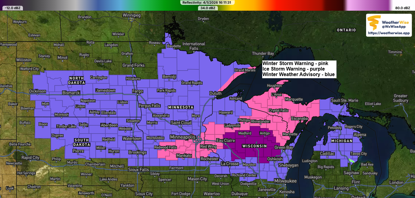
- A messy mix of snow, sleet, and freezing rain is expected in northwest Wisconsin and eastern Minnesota from Thursday into Thursday evening, with some ice accumulation possible.
Duluth area: Snow will start to develop tonight, with up to an inch of accumulation possible by 8 AM Thursday. Snow will continue through the day and evening on Thursday, with the heaviest snowfall expected in the afternoon into the evening. Snow should taper off late Thursday night around midnight. There’s a slight chance the snow could mix with sleet or freezing rain Thursday afternoon and evening, though that’s less likely than it was yesterday. Northeast winds will gust between 25 and 45 mph tonight and Thursday, leading to some blowing snow at times. Temperatures will hold steady tonight, hovering between 25 and 29 degrees, and will range from about 29 to 32 degrees on Thursday.
Make a one-time donation
Make a monthly donation
Make a yearly donation
Choose an amount
Or enter a custom amount
Thank you for supporting Northland weather blog.
Your contribution is appreciated.
Your contribution is appreciated.
DonateDonate monthlyDonate yearly…Snowfall Potential…
Here’s my updated snowfall forecast as of late Wednesday afternoon.
Duluth: Between 4 and 7 inches of snow could fall by late Thursday night.
Overall, expecting a band of 4 to 7 inches of snow in the center, with 2 to 4 inches to the northwest and southeast of that main zone.

…Ice Potential…
Freezing rain is expected Thursday in parts of the Northland, including northwest Wisconsin and eastern Minnesota, with the possibility of 0.05 to 0.20 inches of ice building up during the afternoon and early evening.

NAM 3km model simulated radar forecast through Midnight Friday.
Snow – blue
Mix (sleet/freezing rain) – pink and purple
Rain – green

…Setup…
A low-pressure system over eastern Colorado this afternoon will move northeast, passing near Green Bay, Wisconsin by tomorrow evening.
A strong 30.60+ mb high over James Bay, Canada, and a sub-1000mb low in eastern Colorado are creating a tight pressure gradient. This setup will bring strong northeasterly winds, especially near Lake Superior, lasting through Thursday evening.

Moisture will keep flowing north into the upper Midwest tonight and Thursday, with precipitable water values between 0.50 and 0.80 inches reaching the Northland. Meanwhile, very dry air sits just to our northeast, where precipitable water is only around 0.10 to 0.20 inches today.

Here’s a glimpse at the approaching storm for Thursday, which is becoming increasingly organized over the Rockies today, as seen in water vapor imagery.
Goes-19 water vapor loop ending 5:15 PM CT Wednesday, April 1, 2026.

Leave a Reply