One winter storm is ongoing in the Northland tonight, with another expected Friday night into Saturday.
Note: As of 4 PM today, the National Weather Service in Duluth, Minnesota reported 2.1 inches of snow, with an additional 2 to 4 inches expected by late tonight, which falls within my forecasted range of 4 to 7 inches.
The top three highest snowfall totals recorded on April 2 in Duluth, Minnesota.
1: 6.2″ (1950)
2: 5.7″ (2025)
3: 3.4″ (1971)
We can likely move up to the number 3 spot, but the top two spots are probably secure.
Duluth area: Snow and sleet will continue tonight, with precipitation tapering off early Friday morning between 1 and 4 AM. Expect an additional 2 to 4 inches of snow and sleet. Northeast winds will gust between 25 and 45 mph this evening, easing after midnight. Patchy blowing snow and sleet will persist through the evening. Temperatures will stay steady between 28 and 32 degrees tonight, then climb to around 32 to 34 degrees on Friday. Note: As the strong April sun angle fades late this afternoon, snow and sleet may start to accumulate on the roads more easily than they did earlier.
Make a one-time donation
Make a monthly donation
Make a yearly donation
Choose an amount
Or enter a custom amount
Your contribution is appreciated.
Your contribution is appreciated.
Your contribution is appreciated.
DonateDonate monthlyDonate yearlyHere’s my updated forecast for additional snow and sleet accumulation, valid through 3 AM Friday.
In that 2-4″ zone, isolated totals over 4 inches are possible, though they likely won’t be widespread.

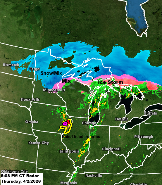
Radar loop ends 4:54 PM CT Thursday, April 2, 2026.
Snow – blue
Rain – green
Mix – pink
Red polygons: Tornado Warning
Yellow polygons: Severe Thunderstorm Warning
Today, peak wind gusts reached 48 mph at Duluth Sky Harbor Airport and 47 mph at Duluth International Airport.

A classic mid-latitude cyclone is on display today, with the center of low pressure near Des Moines, IA, as of mid-afternoon. This system will quickly move northeast, passing near Green Bay, WI, by late this evening.
Up north, the colder air is bringing snow and a wintry mix, with a major ice storm hitting parts of Wisconsin and upper Michigan today. Meanwhile, in the warmer air near the storm’s dry slot, there’s a chance for severe thunderstorms and even a few tornadoes this evening, spanning from northeast Missouri through eastern Iowa, into western and northern Illinois, and down into far southern Wisconsin.


Goes-19 water vapor loop ending 5:01 PM CT Thursday, April 2, 2026.

Leave a Reply