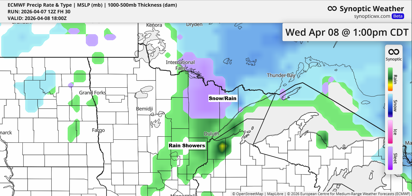
The high pressure that brought bitter cold to the Northland this morning has moved east, making way for milder air as southerly winds pick up ahead of a low-pressure system moving in from the west. This system is set to bring precipitation on Wednesday, with a wintry mix in the far north and Arrowhead, and mostly rain showers farther south, including Duluth.
Note: In Duluth, the highest likelihood of rain looks to be from late Wednesday morning through the early to mid-afternoon.

Euro model simulated radar forecast valid 7 AM to 10 PM Wednesday.

On Wednesday, the heaviest precipitation is expected in far northern Minnesota and the Arrowhead, with totals ranging from about 0.15 to 0.40 inches or more. Farther south, including Duluth, lighter amounts near 0.1 inches or less are likely.

…Thunderstorm chances increasing this weekend…
Multiple rounds of showers, along with some thunderstorms, are expected to sweep across the Northland starting Saturday evening and continue into Monday morning as a few low-pressure systems move through the area.
While severe weather isn’t expected here, these thunderstorms could still bring heavy rain, with totals ranging from half an inch to over an inch possible in northeast Minnesota and northwest Wisconsin from Saturday night through early Monday morning.

Here’s a look at what the Euro model is showing from 1 PM Saturday to 7 AM Monday through its simulated radar forecast.

…Cold Tuesday morning in the Northland…
Low temperatures on April 7, 2026
International Falls, MN
Low: 0
Departure: -23 degrees below normal
Record low: -9 set in 1982
Hibbing, MN
Low: 2
Departure: -20 degrees below normal
Record low: -2 set in 2023
Duluth, MN
Low: 7
Departure: -20 degrees below normal
Record low: 2 set in 1936
Note: In Duluth, the average date for temperatures dropping to 7 degrees or colder is March 21st, with the latest on record April 16 (1875).
Brainerd, MN
Low: 8
Departure: -19 degrees below normal
Record low: 0 set in 1936
Ashland, WI
Low: 14
Departure: -12 degrees below normal
Record low: 1 set in 1982
If you’d like to support the work I do here, you can do so below.
Make a one-time donation
Make a monthly donation
Make a yearly donation
Choose an amount
Or enter a custom amount
Your contribution is appreciated.
Your contribution is appreciated.
Your contribution is appreciated.
DonateDonate monthlyDonate yearly
Leave a Reply