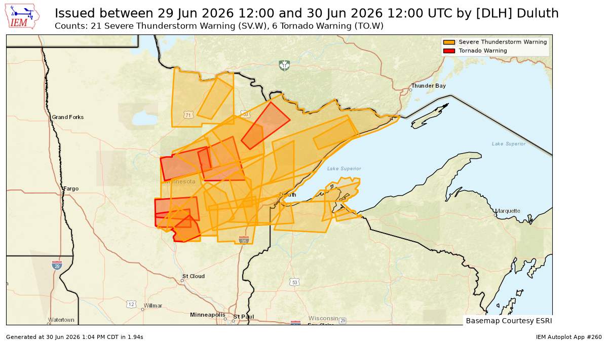
On Monday, June 29, 2026, the National Weather Service in Duluth, Minnesota, issued a total of 27 warnings, including 21 for severe thunderstorms and 6 for tornadoes, across northeast Minnesota and northwest Wisconsin. It was certainly a busy day for severe weather in the area.
Note: Several additional storm reports from Monday and early Tuesday morning, June 29–30, 2026, can be found near the bottom of this post.
Severe Thunderstorm + Tornado warning count for the Northland in 2026 up to June 30th is 60.
Since 1986, the fewest warnings in the Northland by June 30th occurred in 1995 with just one, while the most was in 1998 with a total of 155.

…Severe Chances Wednesday…
On Wednesday, northeast Minnesota and especially northwest Wisconsin could see a few strong to severe thunderstorms. The main concerns are hail up to 1.5 inches in size (ping pong ball size) and winds gusting up to 60 mph.

The greatest rain totals on Wednesday are forecast to fall over north central Wisconsin with lesser amounts expected in northeast Minnesota and along the South Shore in northwest Wisconsin.

It looks like rain showers could move through eastern Minnesota and northwest Wisconsin Wednesday morning, followed by a chance of scattered showers and thunderstorms later in the afternoon and evening.
NSSL HT model simulated radar forecast valid 7 AM Wednesday to Midnight.
If you’d like to support the work I do here, you can do so below.
Make a one-time donation
Make a monthly donation
Make a yearly donation
Choose an amount
Or enter a custom amount
Your contribution is appreciated.
Your contribution is appreciated.
Your contribution is appreciated.
…Temperature change in Duluth today…
At Duluth Sky Harbor Airport, the temperature soared from 57 degrees at 2:15 PM to 87 degrees by 4:15 PM today, all because of a wind shift from the northeast to the southwest.
Warmer offshore winds are expected to stick around near Lake Superior on Wednesday and Thursday, but by Friday and into the weekend, east winds should return, bringing cooler temperatures.

The last day of June in the Northland was warm, with temperatures mostly in the 80s and a few spots reaching into the 90s.
Highs on Wednesday and Thursday will mostly be in the 80s across the Northland, with temperatures in the 70s and 80s expected on Friday and Saturday. A cooling trend is likely near Lake Superior as east winds make a return.
Note: Today’s high of 87 at the Duluth Airport marked only the second day this month with temperatures at or above 80 degrees, the last being June 3rd, nearly four weeks ago. It was also the warmest temperature recorded in Duluth this month.

…Dewpoints…
This afternoon, northwest Wisconsin remains fairly humid with dew points in the 60s, while a drier airmass has moved into northeast Minnesota, bringing dew points down to the 40s and 50s.

On Wednesday, humidity could shift back north, with dew points rising into the 60s in northeast Minnesota and possibly reaching the low 70s in northwest Wisconsin.

What a powerhouse of a system to close out June, with a strong surface low near 990mb and an impressive mid- and upper-level low over Manitoba today.
Goes-19 water vapor loop ending 5:40 PM CT Tuesday, June 30, 2026.

Additional Storm Reports from June 29-30, 2026
1:52 AM – 6/30: Thunderstorm Wind Damage. Fredenberg, MN (St. Louis County). Aspen trees on road.
1:03 AM – 6/30: Thunderstorm Wind Damage. 4 S Brimson, MN (St. Louis County). Estimate of at least a dozen downed trees around White Lake, with damage to power lines.
12:36 AM – 6/30: Thunderstorm Wind Gust 54 mph. 4 SSE Eveleth, MN (St. Louis County)
12:35 AM – 6/30: Thunderstorm Wind Damage. 1 ENE Zim, MN (St. Louis County). Trees down on power lines and house.
12 AM – 6/30: Thunderstorm Wind Damage. 3 E Jacobson, MN (Aitkin County). A large birch tree across Highway 200 blocking the road. Multiple trees were down in this area.
11:59 PM – 6/29: Thunderstorm Wind Damage. Jacobson, MN (Aitkin County). 6–8-inch white pine limb skewered into the ground.
11:22 PM – 6/29: Thunderstorm Wind Damage. 2 ESE Emily, MN (Crow Wing County). Very large oak tree uprooted. Several large trees knocked over or snapped some laying on the house.
11:10 PM – 6/29: Thunderstorm Wind Gust 64 mph. 4 NE Brainerd, MN (Crow Wing County)
10:40 PM – 6/29: Thunderstorm Wind Gust 61 mph. Motley, MN (Cass County)
8:22 PM – 6/29: Funnel Cloud. 2 E Brainerd, MN (Crow Wing County). Reported at Highways 25 and 18 in Brainerd.
7:20 PM – 6/29: Hail 1.00″ (quarter size). 2 WSW International Falls, MN (Koochiching County)
5:10 PM – 6/29: Hail 1.00″ (quarter size). 3 S Ashland, WI (Ashland County)
5 PM – 6/29: Hail 1.00″ (quarter size). 3 SSE Ashland, WI (Ashland County)
4:55 PM – 6/29: Hail 1.50″ (ping pong ball size). 2 E Benoit, WI (Bayfield County)
4:53 PM – 6/29: Thunderstorm Wind Damage. Ashland, WI (Ashland County). Multiple trees down in Ashland following the storms.
4:22 PM – 6/29: Hail 0.75″. 2 E Ino, WI (Bayfield County)
3:41 PM – 6/29: Thunderstorm Wind Damage. 2 W Lake Nebagamon, WI (Douglas County). Trees were reported down across County Highways B and P outside Lake Nebagamon.
3:11 PM – 6/29: Thunderstorm Wind Damage. 3 SW Bayfield, WI (Bayfield County). Several large trees down on the highway between Bayfield and Washburn around 12 inches in diameter.
3:05 PM – 6/29: Thunderstorm Wind Damage. 4 SSE Herbster, WI (Bayfield County). Tree down.
2:41 PM – 6/29: Hail 1.75″ (golf ball size). Mahtowa, MN (Carlton County)
2:40 PM – 6/29: Hail 1.75″ (golf ball size). Barnum, MN (Carlton County)
2:37 PM – 6/29: Hail 1.50″ (ping pong ball size). Barnum, MN (Carlton County)
2 PM – 6/29: Hail 2.00″ (hen egg size). Lawler, MN (Aitkin County)
1:45 PM – 6/29: Thunderstorm Wind Damage. 2 S Melrude, MN (St. Louis County). Several trees down.
1:40 PM – 6/29: Thunderstorm Wind Damage. 2 NE Cherry, MN (St. Louis County). Barn collapsed on cattle and the cattle needed to be rescued.
1:15 PM – 6/29: Thunderstorm Wind Damage. Chisholm, MN (St. Louis County). Tree down on a home.
1:05 PM – 6/29: Thunderstorm Wind Damage. 11 N Nashwauk, MN (Itasca County). A few moderate size tree branches were down but no full trees. Wind lasted about 5 minutes.
1:05 PM – 6/29: Hail 1.50″ (ping pong ball size). 14 N Taconite, MN (Itasca County)
1:01 PM – 6/29: Thunderstorm Wind Damage. 6 W Silica, MN (Itasca County)
12:51 PM – 6/29: Thunderstorm Wind Damage. Bovey, MN (Itasca County). Several trees were reported down in Bovey.
12:35 PM – 6/29: Thunderstorm Wind Damage. 2 NW Nisswa, MN (Crow Wing County)
12:34 PM – 6/29: Thunderstorm Wind Damage. 4 SW Mission, MN (Crow Wing County). A 100-foot-tall tree down that had no previous damage. Multiple other smaller trees down as well. Branches were found speared into the ground after the storm.
12:25 PM – 6/29: Thunderstorm Wind Damage. Bena, MN (Cass County). Downed trees in Bena. Some trees were snapped and another was tipped pulling up the roots.
Leave a Reply