6:16 PM Wednesday, April 9, 2025
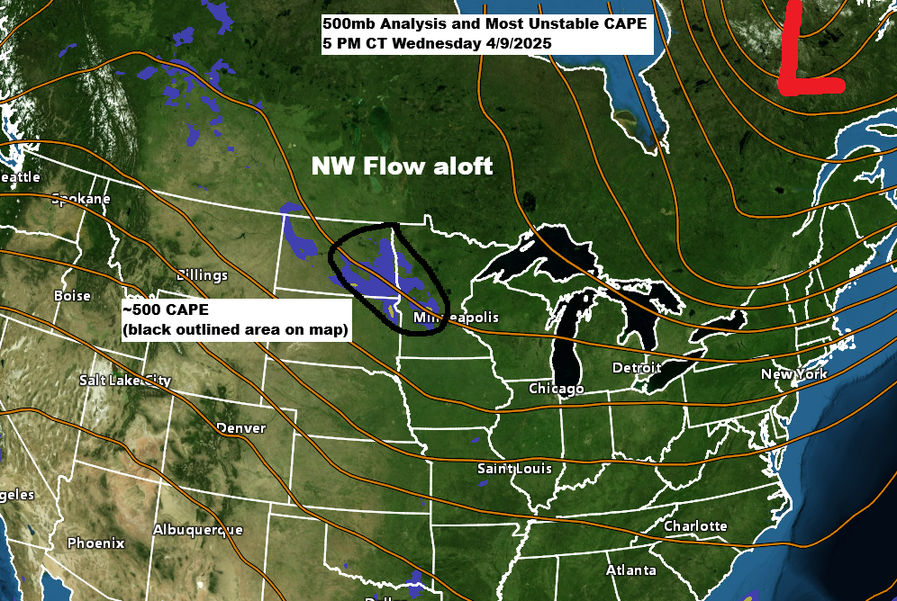
NW flow aloft is keeping temperatures on the cool side today in northeast Minnesota, while a low-pressure system embedded in this NW flow aloft tracks southeast across the Upper Midwest.
We’ve seen quite a range of temperatures across the region today, with 30s in northeast Minnesota where there has been some snow, while warmer 60s covered areas from west central into southern Minnesota, with even a few 70s in southwest Minnesota today.

There’s been a few thunderstorms this afternoon in northwest and west-central Minnesota, as noted by the white, yellow, orange, and red dots which represent lightning strikes on the loop below.
Those thunderstorms in northwest Minnesota are occurring near a pretty potent upper low which is moving east-southeast in eastern North Dakota and far western Minnesota this afternoon.
Goes-16 infrared satellite loop ending 6:01 PM CT Wednesday, April 9, 2025.

A weak low-pressure system extended from northwest Minnesota to eastern Iowa this afternoon and will move south-southeast through Thursday afternoon.

This system has been producing some snow with minor accumulations mainly on grassy surfaces today in parts of northeast Minnesota (mainly north of Duluth), with some scattered rain showers occurring in far northern Wisconsin and east-central Minnesota.
Radar loop ends 4:22 PM Wednesday, April 9, 2025
Some wet snow and light rain will continue in parts of the Northland tonight and Thursday with precipitation diminishing from north to south Thursday afternoon.
NAM 3km model simulated radar forecast through 7 PM Thursday.

Precipitation totals of up to 0.10 inches are possible by Thursday afternoon in parts of northeast Minnesota and far northwest Wisconsin, with locally higher amounts of up to around 0.25 inches possible.

There will also be some snow at times in parts of northeast Minnesota tonight into Thursday morning, but with a marginally cold airmass in place, we’re not looking at much accumulation, with generally a trace to an inch of slushy snow possible through Thursday morning.

Saturday night to Monday will bring some rain showers at times to northeast Minnesota and northwest Wisconsin as a strong upper-level trough and low-pressure system track east-northeast out of the northern Plains.
Some snow may occur behind this system on Monday, particularly in northern Minnesota, with light accumulation expected.

Regarding thunderstorm chances on Sunday
Moisture remains low with dew points in the 40s, resulting in only weak instability (CAPE). However, there should be enough moisture and lift from the approaching trough and low to cause some thunderstorms in parts of the Northland on Sunday, although no severe weather is expected at this time.

Thanks for reading!
Leave a Reply