Now that meteorological summer has ended, let’s review the highest Day 1 Storm Prediction Center Convective Outlook observed in northeast Minnesota and northwest Wisconsin during the summer of 2025, spanning from June 1 to August 31.
Moderate risk (level 4 out of 5): One day, June 20.
Enhanced risk (level 3 out of 5): One day, June 16.
Slight risk (level 2 out of 5): 16 days, with the most recent occurrence on August 21.
Marginal risk (level 1 out of 5): 24 days, with the most recent occurrence on August 22.
Marginal risk, the lowest level of severe storm risk, was the most frequent occurrence in the Northland during the summer of 2025.

So far this year, there have been 124 severe thunderstorm and tornado warnings in northeast Minnesota and northwest Wisconsin, which is quite similar to the numbers reported by August 31 last year.
Since 1986, the most active year was 2008, with 268 severe thunderstorm and tornado warnings in the Northland by August 31. In contrast, the least active year was 1993, with just 19 warnings.

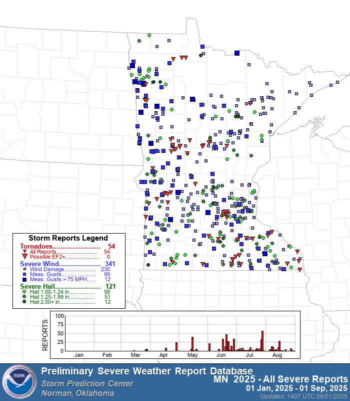
Minnesota has experienced 54 tornadoes this year, along with 341 reports of severe wind and 121 reports of severe hail.

Wisconsin has experienced 37 tornado reports this year, along with 296 reports of severe wind and 140 reports of severe hail.

During the 1995-2024 climate period, Minnesota experienced an average of 44 tornadoes, while Wisconsin saw an average of 24 tornadoes.
The year 2025 has seen a higher than average number of tornadoes in both Minnesota and Wisconsin.

Leave a Reply