Lake Effect Snow Potential Saturday-early Sunday morning
Plenty of cold air is sweeping across Lake Superior, with 850mb temperatures dropping to around -15°C, while the lake water remains much warmer at about +6 to +8°C, or in the low to mid-40s Fahrenheit.
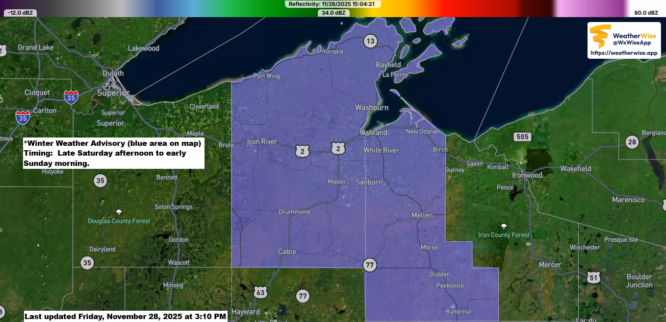
As a surface low moves through the Midwest on Saturday, winds to its north will shift to the east-northeast at about 2,500–5,000 feet (925–850 mb), while surface winds will stay more northerly. This setup means most of the lake effect snow will target the South Shore of Lake Superior, though there’s a chance some could reach parts of the North Shore including the Twin Ports if low-level winds turn a bit more to the east-northeast.

Here’s my snowfall forecast ending 6 AM Sunday.
South Shore could get 2 to 5 inches of snow, while other areas in northwest Wisconsin might see anywhere from just a dusting to 2 inches. Similar amounts are expected from east central Minnesota through the Twin Ports, Two Harbors, and Silver Bay.

Make a one-time donation
Make a monthly donation
Make a yearly donation
Choose an amount
Or enter a custom amount
Your contribution is appreciated.
Your contribution is appreciated.
Your contribution is appreciated.
A major winter storm is set to hit the Midwest late tonight through Sunday morning, as low pressure in eastern Colorado moves northeast, passing through central Missouri, skirting east of Chicago, and reaching southern lower Michigan by around 6 AM Sunday.
The storm track is passing too far south of the Northland to bring significant snowfall to our area this weekend, but light snow is likely in the southern parts, along with some lake effect snow near Lake Superior.
There is plenty of cold air available for this next winter storm, thanks to a strong area of high pressure over western Canada, which drops southeast into the northern Plains by Sunday.

NAM-Nest model forecast valid 7 PM Friday to 7 AM Sunday.

Winter storm warnings and advisories cover a wide area from the northern Rockies to the Midwest and Great Lakes due to the upcoming storm system.


I don’t usually include teleconnections in my forecasts, but today I’m sharing the MJO, or Madden-Julian Oscillation, forecast, which is considered a key teleconnection pattern.
A teleconnection is a climate pattern that affects weather conditions in regions far from where it starts.
The MJO is part of teleconnections because its tropical convection changes atmospheric circulation, which then spreads into the extratropics.
Each of the eight phases of the MJO shifts the jet stream and storm tracks in unique ways.
The MJO is currently between phases 6 and 7, but it’s expected to make a strong shift into phase 7 and could advance into phase 8 within the next week or two.
In northeast Minnesota and northwest Wisconsin, phases 7 and 8 often bring colder temperatures and stronger storms when other weather patterns align, with phase 8 frequently being one of the strongest phases for arctic outbreaks.

Sure enough, looking at the temperature anomaly forecast from the three ensemble models (Euro, GFS, and Canadian) for days 3–7, or November 30 to December 5, 2025, there’s a clear colder-than-average signal showing up in northeast Minnesota and northwest Wisconsin, marked by the blue and purple colors.
I think we’ll see subzero low temperatures in the Northland sometime between this weekend and late next week, with a couple of brief shots of arctic air moving through the area.


With the MJO moving into phase 7 and possibly phase 8, we could see a more active snowfall pattern in the Northland over the next two weeks. It’s uncertain whether this will come from multiple clippers bringing light to moderate snow, stronger systems from the south delivering heavier snowfall, or a combination of both, but ensemble models are signaling decent precipitation totals for northeast Minnesota and northwest Wisconsin through December 13, 2025. The Euro ensemble model forecast is shown below.

Leave a Reply