After a pause in the clipper train, it looks like we’re shifting back into a pattern that’s favorable for clipper systems to move through the upper Midwest over the next 5 to 7 days.
Clippers are weather systems that come from Canada and move southeast along a northwesterly flow aloft. Because they originate in Canada, they don’t carry much moisture, which usually results in light snowfall.
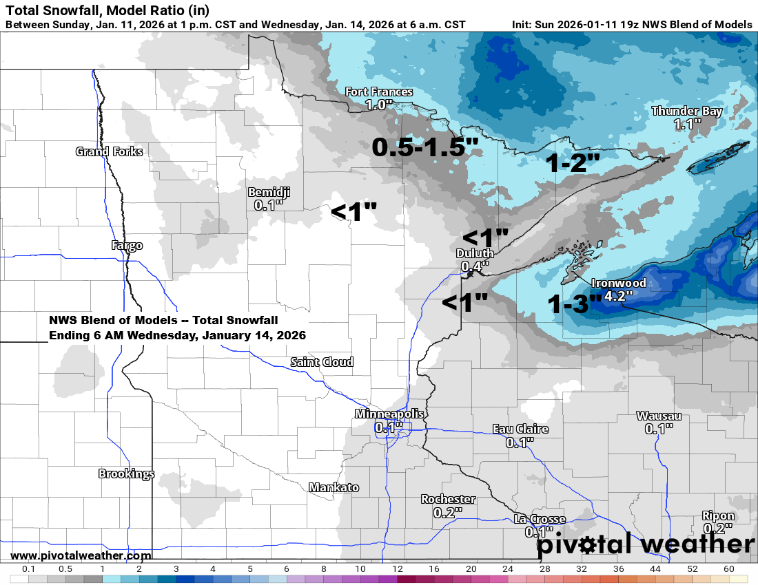
New snow accumulations by Wednesday morning could total 1 to 2 inches in far northern Minnesota into the Arrowhead, less than an inch in Duluth, and about 1 to 3 inches in the snowbelts of northern Wisconsin, where a period of lake-effect snow is likely Tuesday night/early Wednesday morning.
The first clipper is moving through the Northland late this afternoon, bringing a brief period of lift and warm air advection that’s causing snow to spread east across northern Minnesota from mid to late afternoon.

Note: A brief burst of snow will move through Duluth early this evening, ending by 6 PM with up to half an inch of accumulation. The rest of tonight and Monday will remain dry.
Snow along the North Shore, Arrowhead, and far northern Wisconsin should taper off by around 8 PM tonight.
Radar loop ends 5:08 PM Sunday, January 11, 2026.
…Second Clipper Tuesday…
Another clipper will move through the Northland late Monday night into Tuesday morning, bringing more snow and possibly a wintry mix. Scattered snow showers are expected Tuesday afternoon and night as colder air starts to settle in.
NAM 3km model simulated radar forecast valid Midnight Tuesday to Midnight Wednesday.

…Temperature trends this month…
January 2026 has gotten off to a mild start in Minnesota and Wisconsin.
In Duluth, the average temperature through January 10, 2026, is about 6 degrees warmer than usual, with similar mild conditions across northeast Minnesota and northwest Wisconsin, where average monthly temperatures are running roughly 5 to 8 degrees above normal.

Here’s a glimpse at the daily average temperature departures in Duluth, Minnesota, from December 1, 2025, to January 10, 2026.
Since December 1st, Duluth has seen more days colder than average compared to warmer ones. It looks like Monday and Tuesday will add two more above-average days before a shift to a colder pattern sets in by midweek and continues beyond.

Leave a Reply