Category: temperature data
-
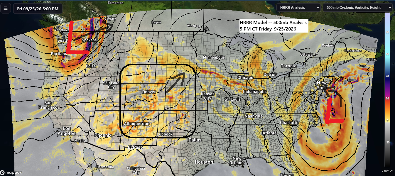
🌦️A bit of weekend rain is on the horizon as the large-scale weather pattern remains active.
The mid and upper-level pattern shows a strong nor’easter over the western Atlantic Ocean, drifting west-northwest and sticking around into early next week. Over the Pacific Northwest, another powerful system is moving northeast into western Canada. Meanwhile, weaker energy over the central and southern Plains and Rockies will lift northeast,…
-
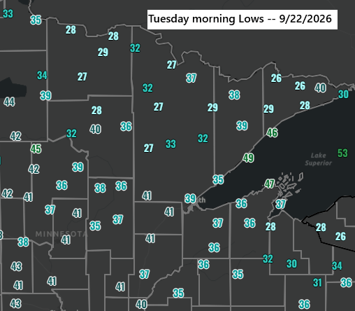
Low Temperature Report – September 22, 2026
This morning, September 22, 2026, brought the earliest first temperatures of 28 degrees or colder since 2020 in International Falls (9/9/2020) and Ashland (9/18/2020). In Hibbing, it was the earliest first occurrence since 2023 (9/13/2023). Low temperature reports for Tuesday morning, September 22, 2026. Seagull Lake, MN: 26Cook, MN: 27Crane…
-

🌤️🌦️Frost Advisory Tuesday Morning; Light Thursday Showers for Parts of the Northland
A Frost Advisory will be in effect early Tuesday morning for much of northeast Minnesota, excluding the North Shore, and for all of northwest Wisconsin. Forecasted temperatures reaching 34 degrees or lower are expected to produce frost, with the most significant risk occurring in areas inland from Lake Superior. No…
-
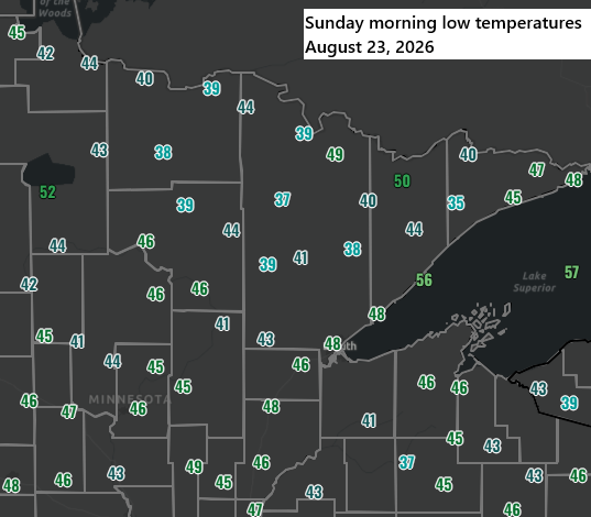
August 23, 2026: Northland Low Temperature Reports Below 40°F
This morning brought a crisp start across the Northland, with temperatures dipping into the mid-30s to around 40 degrees. Hog Creek, MN, recorded the lowest temperature at 35 degrees. Sunday Morning Low Temperature Reports – August 23, 2026 In International Falls, MN, August typically brings just 2 days with lows…
-

🌦️ Wet North, Dry South Over the Past Three Weeks; Saturday Brings Only Modest Rain
Over the past three weeks, far northern Minnesota has experienced a shift to a wetter pattern, with several rain events resulting in precipitation ranging from 100% to nearly 200% of normal since July 21. In contrast, southern areas have remained much drier during the same period, receiving only 2% to…
-
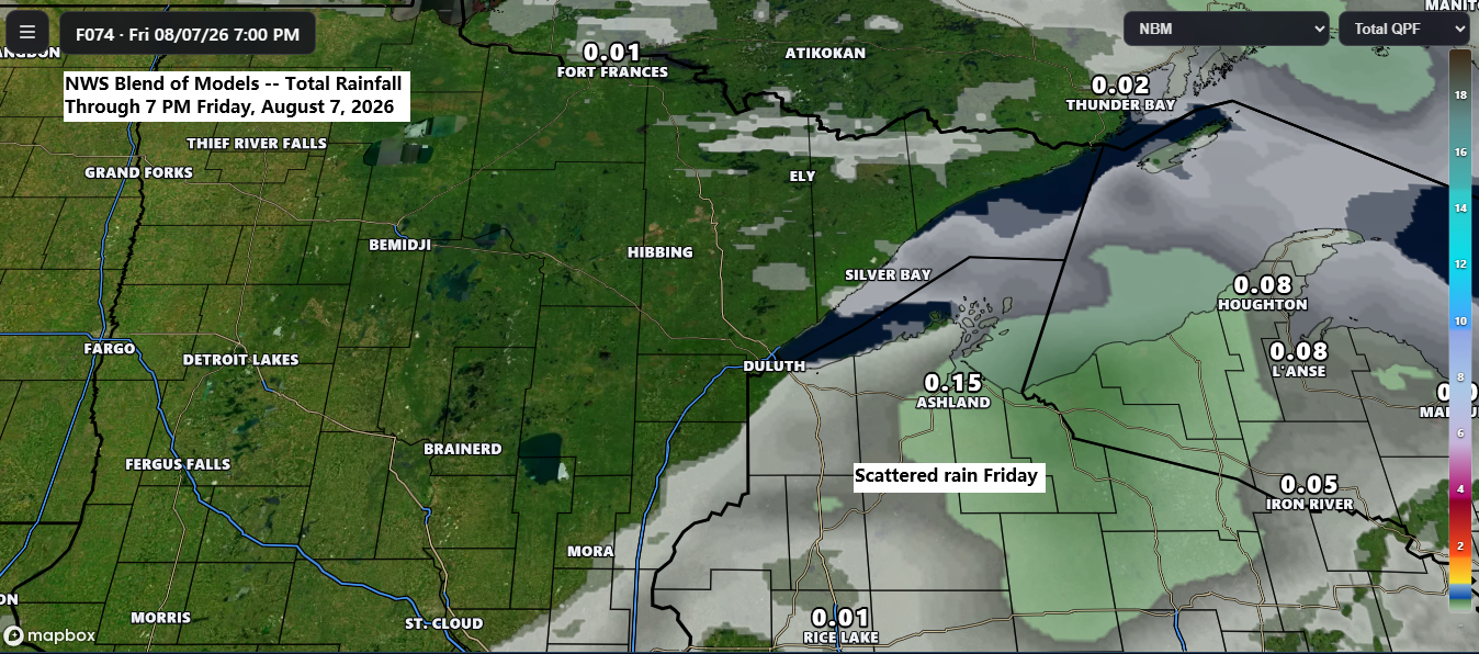
🌤️ Best Weather of the Summer Arrives, With Just a Few Friday Showers Possible
It looks like we’re in for the nicest stretch of weather this summer in northeast Minnesota and northwest Wisconsin, with dry days ahead, low humidity, and pleasantly warm afternoons. The only real chance for rain through early next week is on Friday, mainly in northern Wisconsin, where a few scattered…
-
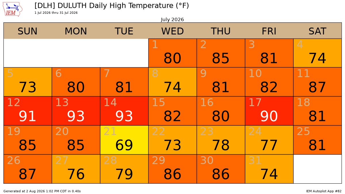
🏆 July 2026 ranks among the top three warmest Julys ever recorded in Duluth, MN.
July 2026 was definitely a warm month in Duluth, Minnesota, with plenty of days hitting the 80s and 90s. There were 21 days with temperatures hitting 80 degrees, well above the average of 11. The record is 25 days, set in 2012. There were 4 days with temperatures reaching 90…