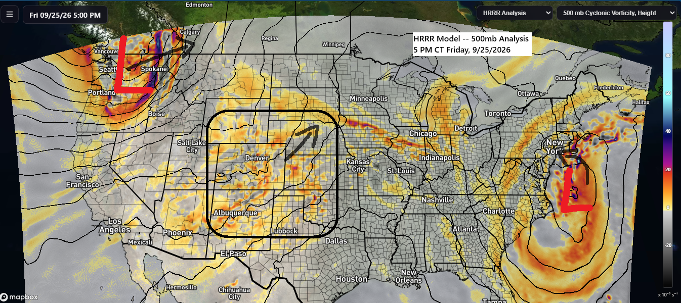
The mid and upper-level pattern shows a strong nor’easter over the western Atlantic Ocean, drifting west-northwest and sticking around into early next week. Over the Pacific Northwest, another powerful system is moving northeast into western Canada. Meanwhile, weaker energy over the central and southern Plains and Rockies will lift northeast, bringing some light rain to parts of the Northland on Saturday.
Rain could move northeast into our area late Saturday morning or early afternoon, with a chance of reaching the Twin Ports later in the day, most likely between 4 and 7 PM.

It’s shaping up to be a lot like a few days ago, with the heaviest rain—about a quarter to half an inch—falling over western and central Minnesota. Much lighter amounts are expected to the east, including the Twin Ports, where totals should stay under 0.1 inches by Saturday evening.

Today’s high of 67 in Duluth on September 25th was the warmest in about a week, since it hit 70 on September 17th.
This month in Duluth, there have been 13 days warmer than average and 10 days cooler than average.

…A Nor’easter is expected this weekend…
A powerful nor’easter is set to hit parts of the Mid-Atlantic and northeastern U.S. in the coming days, bringing strong winds, heavy rain, and flooding.
Today’s storm has brought the strongest wind gusts offshore, hitting 40 to 60 mph or more, but some of that wind will push farther northwest this weekend, with gusts of 50 mph or higher likely, especially along the coast.

Rainfall of 2 to 4 inches or more is expected from New York City to Boston through Monday.

Satellite imagery capturing this weekend’s nor’easter.
GOES-East infrared satellite loop from Friday, September 25, 2026, covering the period from 11:20 AM to 5:15 PM CT.
…Hurricane Polo…
On Friday afternoon, September 25, 2026, Hurricane Polo was a powerful Category 5 storm with winds reaching 180 mph and a central minimum pressure of 913 mb, or 26.96 inches. Polo was about 395 miles south of Cabo San Lucas, Mexico, moving west at 10 mph.
GOES-West infrared satellite loop from Friday, September 25, 2026, spanning from 11:25 AM to 5:15 PM CT.
Polo is expected to start shifting north and then northeast over the next few days, with the storm likely making landfall in central Baja California on Monday afternoon, September 28th, as a category 2 hurricane packing winds between 110 and 130 mph. The remnants of Polo could drift into parts of New Mexico and west Texas by the middle of next week, weakening into a tropical depression.

Leave a Reply