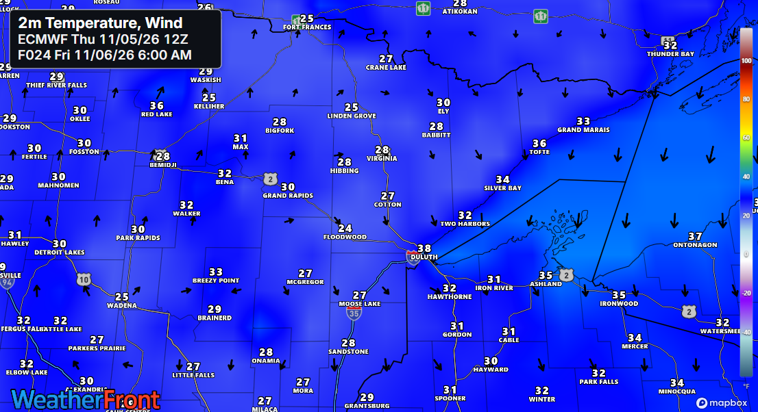
Friday morning will be a bit brisk, with temperatures dropping into the 20s and low to mid-30s across northeast Minnesota and northwest Wisconsin—nothing out of the ordinary for early November.
…Fall 2026 Temperature Trends…
It’s been a warm fall in Duluth, and even the cooler air mass we’re experiencing now—and will again on Friday—isn’t particularly cold for early November. Temperatures are expected to return to the 40s and 50s this weekend and into early next week.
Daily average temperature departure in Duluth from September 1, 2026, to November 5, 2026.

The temperature pattern in the Northland will remain consistent through mid-month, with more days experiencing above-average temperatures than below-average ones. There are no prolonged frigid air masses expected anytime soon.
Euro ensemble model temperature anomaly forecast through November 20, 2026.
Orange and red shades indicate above-average temperatures, while blue areas show below-average temperatures.

…Today’s Weather 11/5/2026…
Cooler air, more typical of November, moved into the area today. Our highs occurred around midnight last night, with temperatures in the mid to upper 40s, but throughout the day, they dropped into the 30s and lower 40s, accompanied by a breezy north wind.

Today, some of the strongest winds have swept across the Arrowhead of Minnesota, Lake Superior, and upper Michigan. North winds over Lake Superior have been gusting at more than 50 mph.
The peak wind gust in Duluth today reached 40 mph.
Today’s wind gusts, Thursday, November 5, 2026, are shown from the RTMA model, covering the loop from 5 AM to 4:45 PM CT.
The low that was over the upper Midwest on Wednesday evening is moving east through Quebec, Canada tonight.
Water vapor loop from Thursday, November 5, 2026, loop time ends 4:55 PM CT.
Behind the low over eastern Canada, cold air has pushed south, causing rain to mix with snow in parts of Upper Michigan and northern Wisconsin, where lake effect precipitation has occurred today. Meanwhile, mostly snow has been falling in parts of eastern Ontario.
MRMS radar loop for Thursday, November 5, 2026, ending at 4:56 PM CT.
If you’re hoping to catch some snow, head east—there might be up to an inch in spots along the South Shore of Lake Superior, stretching from northeast Wisconsin to upper Michigan.
Blend of models total snowfall through 7 AM Friday, 11/6/2026.

On November 4, 2026, the Northland experienced record-breaking precipitation once again.
Hibbing, MN
New record: 1.21″
Previous record: 0.68″ set in 1993
International Falls, MN
New record: 0.69″
Previous record: 0.60″ set in 2003 and 2017
Brainerd, MN
New record: 0.47″
Previous record: 0.44″ set in 1925
Note: Duluth matched its record rainfall for November 4th, measuring 1.02 inches, a mark originally set back in 1880.
Typically, Duluth sees no days in November with an inch or more of precipitation, but in 2026, there have already been two such days. The record for November is three days, set in both 2000 and 1983.
Leave a Reply