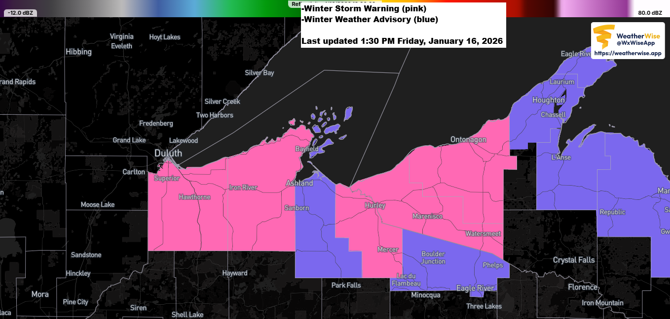
Winter storm warnings and advisories are in effect for the South Shore of Lake Superior in northwest Wisconsin, with 3 to 6 more inches of snow expected by Saturday morning and over 6 inches possible in spots like Gile and Hurley.
Late this morning, a report came in of 10.7 inches of snow falling about 7 miles east of Superior, Wisconsin.

The clipper system really outdid itself in parts of the Northland last night, bringing 3 to 4 inches of snow to Duluth and Superior, and dropping more than half a foot just east of Superior, Wisconsin.
Late Thursday evening, a narrow band of moderate to heavy snow with large flakes formed near and over the Twin Ports. This band stayed nearly stationary for several hours, and with such big snowflakes, the accumulation built up quickly.
Other spots in the Northland picked up around 0.5 to 2 inches of snow last night.
Snowfall Reports for January 15-16, 2026, ending around Noon on the 16th.
Wentworth, WI: 8.5″
Hawthorne, WI: 8.0″
Cloverland, WI: 6.0″
Maple, WI: 5.5″
Brule, WI: 5.4″
Cook, MN: 5.1″
Solon Springs, WI: 5.0″
Red Cliff, WI: 4.5″
Duluth, MN: 4.3″ (official total at the NWS)
Cornucopia, WI: 4.3″
Proctor, MN: 4.3″
Duluth, MN: 4.0″
Gile, WI: 4.0″
Superior, WI: 3.5″
Esko, MN: 3.5″
French River, MN: 3.5″
Fond Du Lac, MN: 3.5″
Bayfield, WI: 3.4″
Snow Bank Lake, MN: 3.3″
Herbster, WI: 3.2″
Warba, MN: 3.0″
Gary New Duluth, MN: 3.0″
Hermantown, MN: 3.0″
Cloquet, MN: 2.9″
Embarrass, MN: 2.8″
International Falls, MN: 2.7″
Lester Park, MN: 2.7″
Pleasant Valley, MN: 2.5″
Two Harbors, MN: 2.4″
Webb Lake, WI: 2.4″
Ely, MN: 2.3″
Floodwood, MN: 2.2″
Mahtowa, MN: 2.1″
Grand Rapids, MN: 2.0″
Castle Danger, MN: 2.0″
Hurley, WI: 2.0″
Stanberry, WI: 2.0″
Hayward, WI: 1.8″
Libby, MN: 1.5″
Shell Lake, WI: 1.5″
Grand Marais, MN: 1.3″
Duquette, MN: 1.3″
Silver Bay, MN: 1.3″
Walker, MN: 1.3″
Marcell, MN: 1.1″
Cass Lake, MN: 1.1″
Bena, MN: 1.0″
Federal Dam, MN: 0.6″
Sandstone, MN: 0.5″
Hibbing, MN: 0.5″
Grantsburg, WI: 0.3″
Leave a Reply