Expect windy and much cooler conditions tonight and Thursday near Lake Superior, with northeast winds gusting up to 30 mph. There could also be areas of dense fog, along with the chance of patchy freezing drizzle that may leave a thin layer of ice on surfaces during this time.
…NWS Blend of Models total ice through 6 AM Friday…

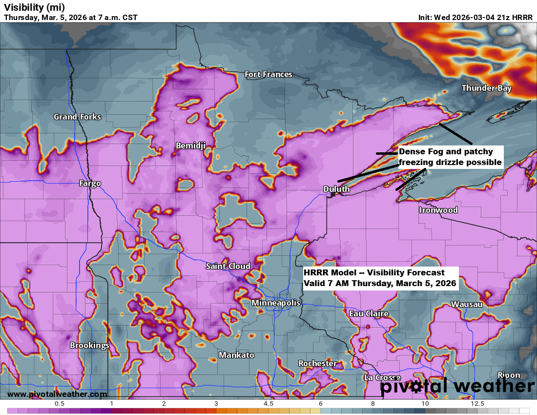
Dense fog advisory is in effect until 12 PM Thursday, including the Twin Ports, where visibility of a quarter to half a mile in dense fog is expected. An expansion to this dense fog advisory may be needed later tonight as dense fog spreads further inland.

…Friday’s System…
A cold front moving east from the Dakotas on Friday will join forces with energy lifting east-northeast from the central Rockies, bringing some precipitation to northeast Minnesota and northwest Wisconsin from Friday into early Saturday morning.
Most of the precipitation will probably come as rain, but there’s a chance for a short spell of wintry mix or wet snow from Friday afternoon into Friday night, moving west to east across the Northland.
It still doesn’t look like this system will fully come together, which should keep precipitation on the lighter side, with totals possibly reaching about a quarter of an inch from Friday into Friday night.
Euro model simulated radar forecast valid 6 AM Friday to 12 PM Saturday.

…Snowfall Forecast Friday afternoon-Friday night…
Northern Minnesota might get up to an inch of slushy snow, while east central Minnesota, Duluth, northwest Wisconsin, and the North Shore of Lake Superior are expected to see less than an inch based on current forecasts.
Here’s the snowfall from the NWS Blend of Models

…Today’s setup…
Much of Canada remains under a blanket of cold Arctic air, with a lobe of that chill racing southwest over Lake Superior as a cold front this afternoon. Ahead of the front, temperatures climbed into the 40s and 50s, but once it passed, they dropped sharply into the upper 20s and low 30s near Lake Superior, along with gusty northeast winds and thick fog.
Note: This afternoon at Duluth Sky Harbor Airport, the temperature dropped from 50 to 33 degrees in just 20 minutes, between 2:35 and 2:55 PM, as the winds shifted to the northeast.
Note: Hibbing, Minnesota reached 50 degrees for the first time this year, with a high of 54. Typically, the first 50-degree day comes around March 20, while the earliest on record was January 23 back in 1942. Today’s 54-degree high wasn’t a record for March 4, though—the record stands at 56 degrees, set in 2000.

Thursday’s highs are expected to range from the mid-20s to low 30s near Lake Superior, climbing into the 30s and 40s farther inland, with temperatures possibly reaching around 50 degrees near Siren and Spooner.

Low clouds and fog covered much of Lake Superior today, with a blanket of fog drifting southwest into the Twin Ports late this afternoon.
Goes-16 Day Cloud Phase satellite loop ending 3:51 PM Wednesday, March 4, 2026.

…Severe Thunderstorm Chances…
Scattered strong to severe thunderstorms are expected tonight, extending from north Texas to southern Illinois, with the main threats being large hail and damaging winds.

On Thursday, there’s a chance of large hail, strong winds, and a few tornadoes across an area stretching from north Texas to south-central Kansas.

The severe weather threat is set to peak on Friday, with storms expected to spread from eastern Kansas and western Missouri down to eastern Oklahoma. This area faces an enhanced risk, rated level 3 out of 5, for severe thunderstorms. All hazards are possible, including large hail, damaging winds, and tornadoes, with a few strong tornadoes especially in the enhanced risk zone.
On Friday, a few strong to severe thunderstorms could push as far north as southeast Minnesota and the southern half of Wisconsin, bringing hail and gusty winds as the main threats.

Leave a Reply