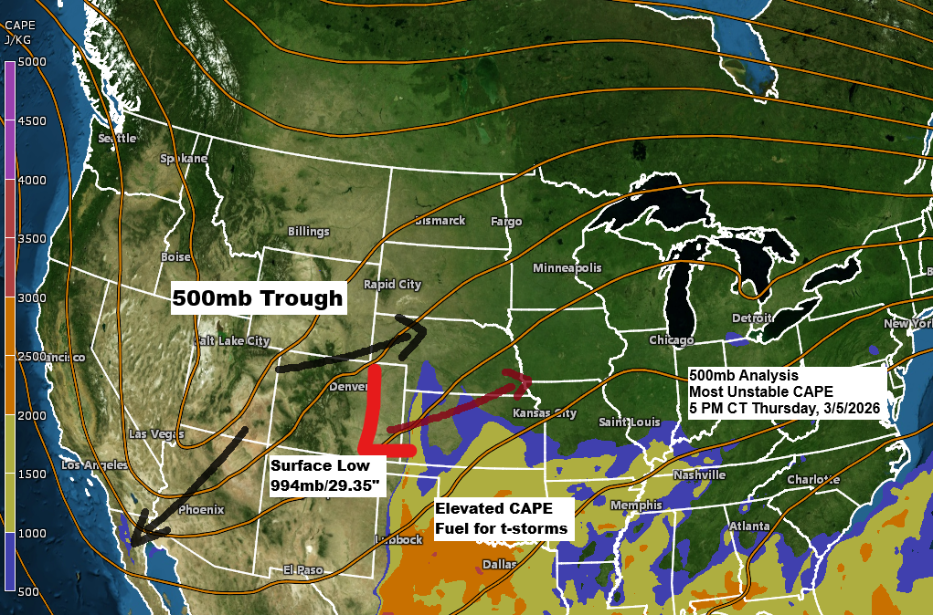
It’s a bit of a messy setup with a strong mid-to-upper level trough over the Rockies and a low-pressure system in eastern Colorado, with southwest winds aloft ahead of it. Normally, this kind of pattern could bring a strong storm to the upper Midwest, but this time the upper trough will split into two, with some energy sliding southwest toward the Baja region and another piece moving east-northeast into the upper Midwest. The surface low over eastern Colorado also isn’t expected to strengthen much as it heads east-northeast. For the Northland, this means no major wintry weather—just some rain showers Friday, switching to a mix and wet snow from west to east Friday night, lingering into early Saturday morning before moving out.
…Ice and Dense Fog near Lake Superior…
Freezing drizzle and dense fog will stick around tonight near Lake Superior, including the Twin Ports, leaving a thin layer of ice on surfaces. A winter weather advisory is in place until midnight for the areas marked in blue on the map, though it could be extended past that time.
This afternoon in Duluth, temperatures were in the mid to upper 20s and are expected to hold steady through the night before slowly climbing on Friday to around 32 to 34 degrees.

A dense fog advisory is in effect until noon Friday for the gray-shaded areas on the map, with visibility expected to range from a quarter to half a mile. The fog is expected to start clearing by Friday afternoon.

…Precipitation totals…
By early Saturday morning, much of northwest Wisconsin could get half an inch or more of precipitation, while northern Minnesota may see around 0.10 inches or less. In between, including Duluth, totals could range from about 0.10 to 0.25 inches.
Note: So far this year, Duluth has received 2.04 inches of precipitation, which is only 0.13 inches below the normal amount for this time of year.

It still doesn’t look like a big snow event for the Northland, with totals expected to be anywhere from just a dusting to about an inch of slush. If we see any snow, it likely won’t show up until Friday night or early Saturday morning.
Note: So far, 54.9 inches of snow have fallen in Duluth during the 2025-2026 snow season, which is 15.3 inches below the normal amount for this time of year.

Additional ice accumulations of a light glaze up to 0.10 inches are possible tonight near Lake Superior, with another round of mixed precipitation possible Friday night resulting in another glaze of ice in some parts of the Northland.

…Thunderstorm Potential Friday…
Expect a few thunderstorms to move east-northeast through the southern parts of the Northland on Friday into Friday evening. This includes east-central Minnesota, all of northwest Wisconsin, and the Twin Ports. However, no severe weather is expected in the area on Friday.
There’s a chance for a few strong to severe thunderstorms farther south on Friday, with the risk stretching up into southern Minnesota and central to southern Wisconsin. The main hazards include large hail and damaging wind gusts, with a slight chance of an isolated tornado in southern Wisconsin.

Severe thunderstorms are expected across much of the Midwest and central Plains on Friday, bringing the threat of large hail, damaging winds, and tornadoes, some potentially strong at EF2+ intensity. The highest risk, rated level 3 out of 5, includes eastern Kansas, western Missouri, eastern Oklahoma, and western Arkansas.

…Mild Sunday…
If all goes as planned, Duluth could see temperatures climb into the 50s on Sunday with breezy west winds, while much of central and southern Minnesota enjoy highs in the 60s, and a few southern spots might even reach 70 degrees.

Leave a Reply