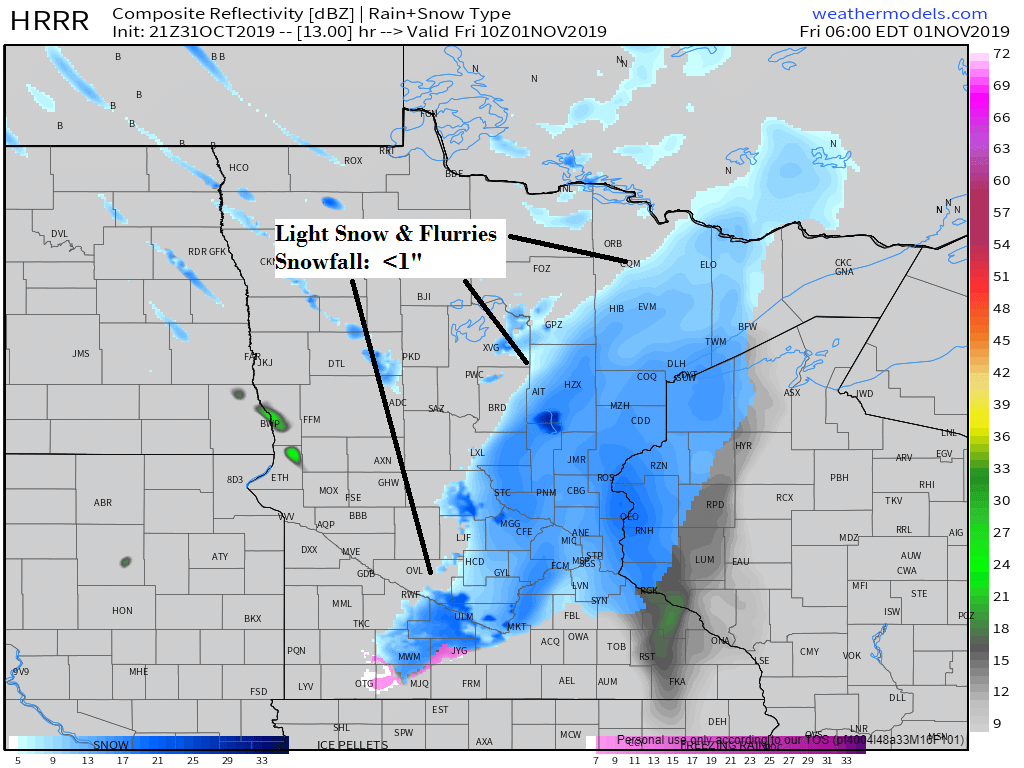
Here’s the radar forecast valid for 5 AM Friday
Source: 21z HRRR model; https://weathermodels.com/

Climate Normals for November at Duluth, Minnesota
- Normal high on the 1st: 44F
- Normal high on the 30th: 28F
- Normal low on the 1st: 28F
- Normal low on the 30th: 14F
- 7 days with snowfall of at least 0.1″
- 3 days with snowfall of at least 1.0″
- 1 day with a subzero low temperature
- Precipitation: 2.09″
- Snowfall: 13.7″
November records at Duluth, Minnesota
- Wettest: 5.08″ set in 2000
- Driest: 0.09″ set in 1917
- Snowiest: 50.1″ set in 1991
- Least snowiest: Trace set in 1928
Past November Snowfall Totals at Duluth, Minnesota from 2000 through 2018.
Note: Normal snowfall in November is 13.7″
- 2000: 17.5″
- 2001: 11.4″
- 2002: 4.3″
- 2003: 19.4″
- 2004: 1.4″
- 2005: 11.4″
- 2006: 4.0″
- 2007: 6.0″
- 2008: 3.2″
- 2009: 1.1″
- 2010: 27.9″
- 2011: 3.7″
- 2012: 10.1″
- 2013: 4.7″
- 2014: 16.4″
- 2015: 4.4″
- 2016: 8.1″
- 2017: 10.5″
- 2018: 12.2″
-Only 4 Novembers since 2000 have had above average snowfall in Duluth (2000, 2003, 2010 and 2014)
Average monthly temperature for November at Duluth, Minnesota from 2000 through 2018.
Note: Mean temperature for November is 28.8 degrees.
- 2000: 28.6 degrees
- 2001: 39.5 degrees
- 2002: 25.6 degrees
- 2003: 26.6 degrees
- 2004: 33.4 degrees
- 2005: 30.7 degrees
- 2006: 31.8 degrees
- 2007: 28.9 degrees
- 2008: 28.9 degrees
- 2009: 37.9 degrees
- 2010: 30.5 degrees
- 2011: 33.1 degrees
- 2012: 30.9 degrees
- 2013: 27.9 degrees
- 2014: 21.8 degrees
- 2015: 36.7 degrees
- 2016: 40.2 degrees
- 2017: 25.7 degrees
- 2018: 23.2 degrees
7 Novembers since 2000 have had a mean temperature which was below normal in Duluth (2000, 2002, 2003, 2013, 2014, 2017 and 2018)
Note: Climate record period for Duluth dates back to 1870.
4 of the top 5 warmest Novembers on record in Duluth have occurred since 2000. 2nd warmest November occurred in 2016, 3rd warmest in 2001, 4th warmest in 2009 and 5th warmest November was in 2015.
One November since 2000 was top 10 coldest, this occurred in 2014 with the 8th coldest November on record in Duluth.
Wettest November on record was in 2000, while November 2002 ranked as 8th driest November in Duluth.
One November since 2000 has ranked in the top 10 for most snow, this was in 2010 with the 7th snowiest November on record in Duluth.
Quite a storm affecting the eastern Great Lakes and east coast today with snow and wind on the cold side in places like Chicago and Milwaukee while a risk of severe thunderstorms and isolated tornadoes occurs on the warm side of this storm over the Mid-Atlantic, south to parts of the Carolinas.
Source: Goes-16 water vapor imagery 10.31.19; https://www.tropicaltidbits.com/

18z HRRR model radar forecast valid from 1 AM tonight to 1 AM Saturday. Source: https://weathermodels.com/
Blue=snow
Green=rain

Low temperature forecast for Friday morning, November 1. Source: https://graphical.weather.gov/

High temperature forecast for Friday, November 1

Still looks cold next week!
Source: 12z European ensemble model 10.31.19; https://weathermodels.com/

…Weather Summary…
Mostly cloudy skies will linger through the night in far northeast Minnesota while clear to partly cloudy skies will continue elsewhere this evening followed by increasing cloudiness.
The first in a series of NW flow systems will move across the Northland on Friday which will be followed by a couple more through early next week. None of these systems look very strong and should only produce a little snow or a rain/snow mix at times from Friday through early next week.
Snowfall amounts with Friday’s system should remain less than an inch for those who happen to get a burst of snow.
Lows tonight will mainly be in the 20s with highs Friday in the 30s.
Southerly winds tonight will become west to northwest Friday at 10 to 20 mph.
Forecast for Duluth and Superior
.Tonight… Clear early then increasing cloudiness. Some light snow possible after 4 AM. Low 23 to 28. Wind south to southwest 5 to 15 mph.
.Friday… Mostly cloudy. Light snow possible early followed by a few snow or rain showers. Snowfall accumulations less than an inch. High 35 to 39. Wind southwest 10 to 20 mph becoming west to northwest.
.Saturday… Mostly cloudy. High 35 to 38. Wind northwest 10 to 15 mph.
Normal temperatures for November 1
- High 44
- Low 29
- Sunrise Friday 7:51 AM CDT
- Sunset Friday 5:53 PM CDT
Thanks for reading!
Leave a Reply