-Wind Chill Advisory (light blue area on map) covers the entire Northland through Noon Wednesday.
-Wind chills 30 to 35 below zero.
-The dangerously cold wind chills could cause frostbite on exposed skin in as little as 30 minutes.
Source: https://www.weather.gov/dlh/

| Low Temperature reports from Tuesday morning, December 10, 2019. Source: https://www.weather.gov/dlh/ 3 E Wright, MN: -19F Babbitt, MN: -19F Cotton, MN: -18F Longville, MN: -18F Pine River, MN: -18F Aitkin, MN: -18F 3 E Orr, MN: -17F Brainerd, MN: -15F Ely, MN: -15F Cass Lake, MN: -13F Crane Lake, MN: -13F Bigfork, MN: -13F Grand Rapids, MN: -13F Walker, MN: -12F Hibbing, MN: -12F Orr, MN: -11F Cook, MN: -11F Siren, WI: -11F Embarrass, MN: -10F Duluth Airport: -9F Grand Marais Airport: -9F Superior Airport: -9F | |
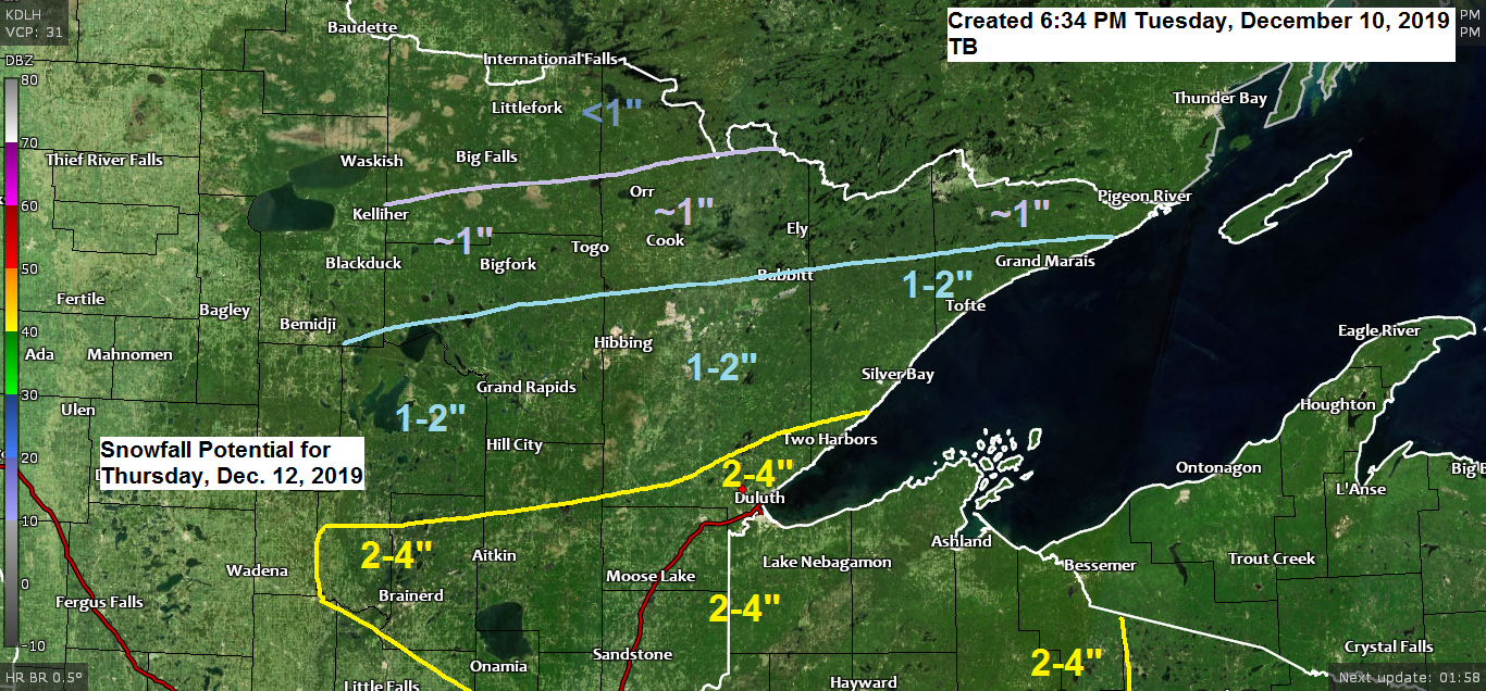
I’m keeping an eye on two snow events for late this week. The first comes on Thursday, the second sometime Friday-early Saturday.
Forecast below is for Thursday’s snow event.

Low temperature forecast for Wednesday morning, December 11. Source: https://graphical.weather.gov/

High temperature forecast for Wednesday, December 11.

…Weather Summary…
An arctic airmass covered the Northland today with even colder air pushing south into the area for tonight. 850mb temperatures at 6 PM Tuesday ranged from -20 to -24C with an area of -26 to -30C H85 temps sitting just north of Minnesota early this evening.
Clear to partly cloudy skies tonight with even colder temperatures compared to last night. Lows tonight will be in the teens and 20s below with a few 30s below even possible in the typical cold spots. Winds will be out of the west at 5 to 15 mph.
Cold on Wednesday with highs in the single digits below to single digits above zero. Partly cloudy skies are expected with winds out of the west at 10 to 15 mph.
Clouds increase Wednesday night which will help keep temperatures from falling too much, but we’re still likely to have lows in the single digits and teens below zero over most of the Northland.
Some snow may begin to affect parts of the area later Wednesday night with some snow also possible on Thursday as a clipper type system moves SE out of the Northern Plains. There is also a chance for a little lake effect snow on Thursday along the North Shore of Lake Superior with a period of east winds possible.
Another snow event may impact parts of the Northland Friday-early Saturday.
Forecast for Duluth and Superior
*Wind Chill Advisory in effect from 9 PM this evening to Noon Wednesday*
.Tonight… Very cold. Clear to partly cloudy. Low 13 below to 18 below. Wind southwest 5 to 15 mph. Wind chills 30 to 35 below.
.Wednesday… Very cold. Partly cloudy. High 1 below to 3 above. Wind west 10 to 15 mph. Morning wind chills 30 to 35 below.
.Thursday… Some snow possible. Mostly cloudy. High 20 to 25. Wind east 5 to 15 mph.
| Normal temperatures for December 11 High 23 Low 9 Sunrise Wednesday 7:44 AM CST Sunset Wednesday 4:20 PM CST | |
Thanks for reading!
Tim
Leave a Reply