Several weak low pressure systems will pass through the upper Midwest through early next week. Not looking at a whole lot of precipitation with any of these systems, so overall it looks fairly dry into early next week in northeast Minnesota and northwest Wisconsin, with that said, there is a chance for a little snow or freezing drizzle in parts of the Northland on Friday but snow accumulations would be very light where it does snow (a few tenths of an inch at most)
| Low temperature reports from around the Northland from Wednesday morning, December 18, 2019. Source: https://www.weather.gov/dlh/ 25 E Ely, MN: -38F Seagull Lake, MN: -36F Babbitt, MN: -34F Cook, MN: -33F Brimson, MN: -32F Bigfork, MN: -31F Orr, MN: -31F Cotton, MN: -31F Floodwood, MN: -29F Ely, MN: -29F Northome, MN: -28F Hill City, MN: -27F Aitkin, MN: -27F Crane Lake, MN: -27F International Falls, MN: -27F Littlefork, MN: -27F Saginaw, MN: -26F Chisholm-Hibbing Airport: -26F 3 E Wright, MN: -25F Deer River, MN: -24F Isabella, MN: -24F Pine River, MN: -24F Walker, MN: -24F South Range, WI: -23F Minong, WI: -23F Barnes, WI: -22F Hinckley, MN: -22F Brainerd, MN: -22F Hayward, WI: -22F Solon Springs, WI: -22F Grand Rapids, MN: -21F Siren, WI: -21F Danbury, WI: -20F Grand Marais Airport: -20F Siren, WI: -20F Superior Airport: -18F Ashland, WI: -17F Butternut, WI: -16F Duluth Airport: -15F | |
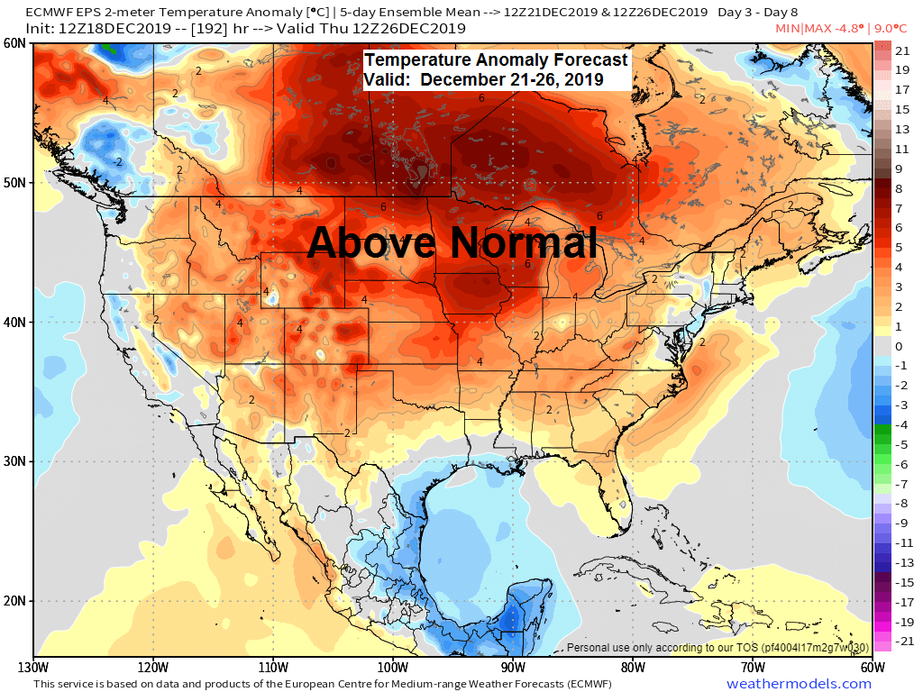
Warming trend begins on Thursday, and will really kick into high gear over the weekend. Warmer than normal temps are expected to linger through most of next week the way it looks now.
Source: 12z European ensemble model 12.18.19; https://weathermodels.com/

Long range computer models agree on a southwest flow aloft developing next week, but disagree as to whether there would be any impactful weather systems which may affect the Northland later next week with some snow, mixed precip or even rain. Stay tuned.
Source: https://www.wpc.ncep.noaa.gov/

Low temperature forecast for Thursday morning, December 19. Source: https://graphical.weather.gov/

High temperature forecast for Thursday, December 19.

Forecast for Duluth and Superior
.Tonight… Partly to mostly cloudy. Low 1 below to 4 above. Wind south 5 to 15 mph.
.Thursday… Partly to mostly cloudy. High 18 to 23. Wind becoming east around 10 mph.
.Friday… Mostly cloudy. High 21 to 26. Wind east to southeast 10 to 15 mph.
| Normal temperatures for December 19 High 21 Low 6 Sunrise Thursday 7:50 AM CST Sunset Thursday 4:22 PM CST | |
Thanks for reading!
Tim
Leave a Reply