-Winter Storm Warning (pink area on map below) remains in effect through 6 AM Monday for parts of north-central and northeast Minnesota including the cities of International Falls, Bigfork, Grand Rapids, Walker, Hibbing, Cook, Ely, Two Harbors, Isabella, Silver Bay and Grand Marais.
-Winter Weather Advisory (purple area on map below) remains in effect from Noon today to Noon Sunday for parts of east-central and northeast Minnesota including the cities of Brainerd, Aitkin, Hill City, Moose Lake, Cloquet and Duluth.
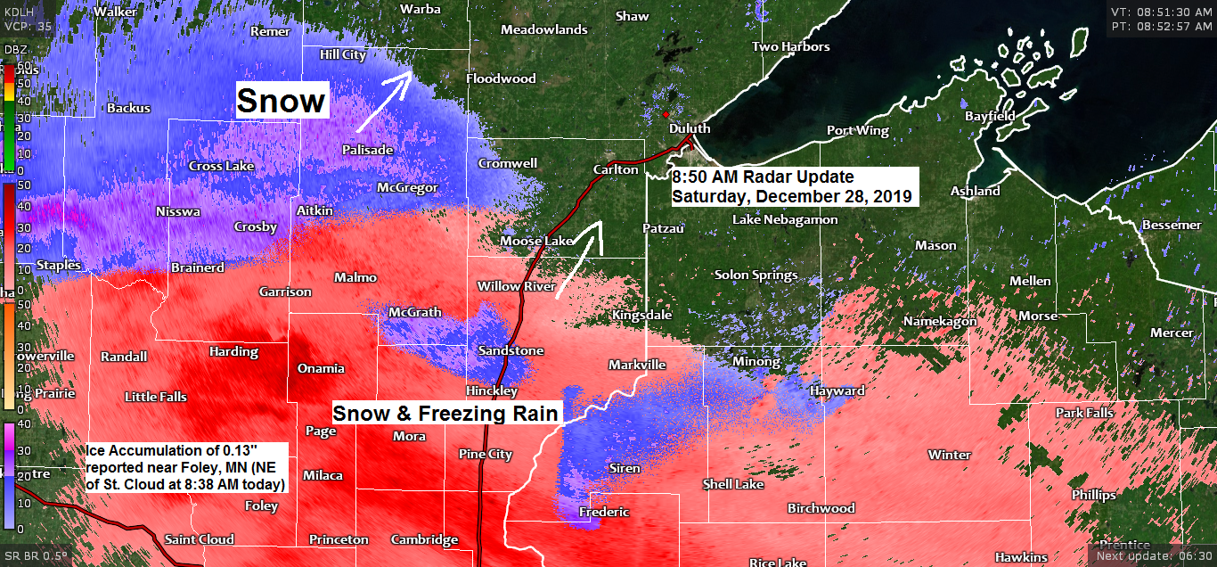
Source: https://www.weather.gov/dlh/

Lakeshore Flood Advisory information

First wave of precipitation which is in the form of snow and freezing rain is lifting N/NE across central and eastern Minnesota this morning. Precipitation should reach Duluth later this morning/early this afternoon.

Here’s my snowfall forecast for part one of this two part winter storm, these totals are through 6 PM Sunday, December 29th.

Road Conditions
Minnesota – https://lb.511mn.org/
Wisconsin – https://511wi.gov/
Low pressure was over the southern Plains early this morning and will lift N-NE reaching northern Iowa/southern Minnesota by Sunday morning. Abundant moisture from the gulf is streaming north out ahead of the surface low.
Source: https://www.spc.noaa.gov/

A look at the moisture per the precipitable water (PWAT) map from 8 AM Saturday.
Still some dry air up in northern Minnesota this morning, but deeper moisture is surging north out of the southern/central Plains and will work into the Northland by later today.

…Outlook for Duluth and Superior…
*Snow or a mix of snow, freezing rain and sleet begins between 10 AM and 1 PM today. A light glaze of ice accumulation is possible late this morning/afternoon.
*Snow or a wintry mix of sleet/freezing rain continues tonight.
*Snow or a wintry mix transitions to light rain or drizzle by Sunday afternoon.
*Areas of fog through Sunday
*Winds shift to the east this afternoon at 5 to 15 mph with east winds really ramping up tonight with gusts 25 to 45 mph developing by late this evening. Wind gusts could approach 60 mph Sunday morning.
*Snowfall accumulations by Sunday afternoon ranging from 6 to 8 inches over the hill in Duluth (higher elevation areas) to 3 to 6 inches below the hill (lower elevation areas)
*There is a chance for some heavy sleet accumulation early Sunday morning, and possibly some ice accumulation as well if precipitation is more freezing rain versus sleet.
*Scattered power outages are possible tonight into Sunday in the Twin Ports and along the North Shore of Lake Superior due to the strong east winds, and if ice accumulations become significant (quarter inch or more) that would increase the potential for widespread power outages.
More updates later today
Thanks for reading!
Tim
Leave a Reply