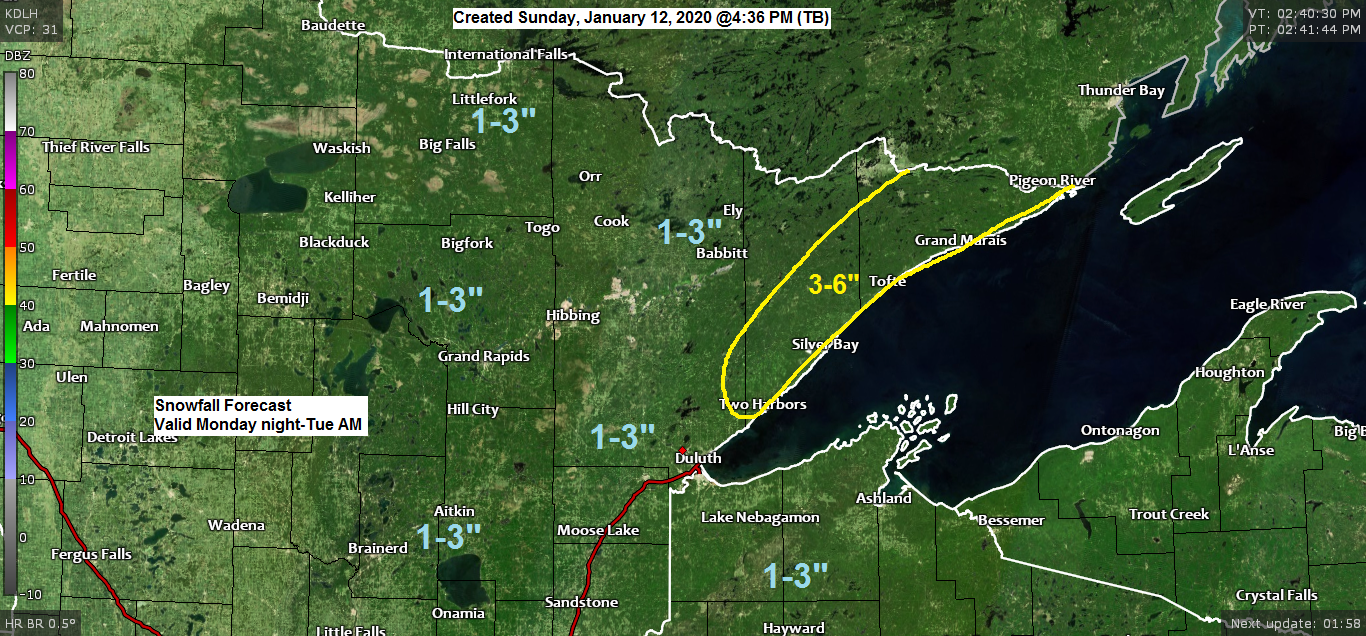
A widespread but fairly short duration snow event is on the way for Monday night-Tuesday morning which could impact the Tuesday morning commute.
Here’s my snowfall forecast for Monday night-Tuesday.
*Highest totals of 3 to 6 inches along the North Shore including Two Harbors, Silver Bay, Isabella and Grand Marais.
*1 to 3 inch totals for the rest of the Northland.

A weak system will pass south of our area tonight, this system could bring a quick shot of light snow to parts of eastern Minnesota and northwest Wisconsin later this evening into early Monday morning, but snowfall totals should remain around an inch or less. Note: Snowfall totals of a half inch or less are possible in Duluth later tonight.
A stronger but quick moving system will affect the Northland Monday night into Tuesday bringing a period of widespread snow to the area. This snow will taper off from SW-NE on Tuesday.
Radar forecast below valid from 7 PM Sunday to 3 PM Tuesday.
Source 18z NAM-WRF model 1.12.2020; https://weathermodels.com/

Here’s a look at tonight’s system moving E/NE out of Nebraska per Goes-16 water vapor imagery. Most of the snow with this one stays south of the Twin Ports tonight.
Source https://weather.cod.edu/

Cold, arctic air bottled up over western Canada and the Northern Rockies with a large area of warmer than normal temperatures covering the southern/eastern US will lead to an active weather pattern across the Plains and Great Lakes this week as several low pressure systems track along the temperature gradient between the arctic air to the NW and the warmer air to the SE.
Source 12z European ensemble model 1.12.2020; https://weathermodels.com/

Low pressure moving east out of the Rockies could bring a widespread snow event to the Northland from Friday into Saturday, January 17-18.
So far model guidance has been in good agreement on the track of this system with potential for 4-6 inch or greater snow totals in northeast Minnesota and northwest Wisconsin late this week, but with this system still a few days away, the track of it could change which could decrease snow amounts in our area. Stay tuned.
Source https://www.wpc.ncep.noaa.gov/

| Snowfall Reports from around the Northland Source https://www.weather.gov/dlh/ Event Dates: January 11-12, 2020 1 SSW Superior, WI: 7.0″ 2 SSW Superior, WI: 6.0″ 2 WNW Two Harbors, MN: 5.0″ 4.1 ENE Cornucopia, WI: 4.2″ 1 WSW Two Harbors, MN: 3.0″ 3 NNW Rice Lake, MN: 2.5″ Little Marais, MN: 2.0″ 1 ENE Superior, WI: 2.0″ 1 W Silver Bay, MN: 1.5″ 1 ESE Esko, MN: 1.5″ Duluth Airport: 1.4″ | |
Low temperature forecast for Monday morning, January 13, 2020. Source https://graphical.weather.gov/

High temperature forecast for Monday, January 13.

| Temperature and Precipitation report for Duluth, Minnesota for January 5 through 11, 2020 High Temperatures/Departure from Normal 1/5: 30F/+11 degrees above normal 1/6: 31F/+12 degrees above normal 1/7: 26F/+7 degrees above normal 1/8: 10F/-9 degrees below normal 1/9: 25F/+6 degrees above normal 1/10: 19F/Normal 1/11: 16F/-3 degrees below normal Low Temperatures/Departure from Normal 1/5: 21F/+19 degrees above normal 1/6: 17F/+15 degrees above normal 1/7: -4F/-6 degrees below normal 1/8: -12F/-14 degrees below normal 1/9: 10F/+8 degrees above normal 1/10: -6F/-7 degrees below normal 1/11: -11F/-12 degrees below normal Note: Average temperature in Duluth for the week of January 5th, 2020: 12.3 degrees; +2.2 degrees above normal. Source https://www.dnr.state.mn.us/ Total Precipitation: 0.04″ Normal: 0.23″ Departure: -0.19″ below normal State Average for Minnesota for the week of January 5th, 2020 Temperature 15.6 degrees Departure +4.5 degrees above normal Precipitation 0.02″ Departure -0.16″ below normal | |
Average temperature, departure from mean for the week of January 5th, 2020. Source https://mrcc.illinois.edu/

Total precipitation, departure from normal for the week of January 5th, 2020.

Forecast for Duluth and Superior
.Tonight… Mostly cloudy. A little light snow or flurries possible late. Low 10 to 15. Wind east to southeast 10 to 15 mph.
.Monday… Partly to mostly cloudy. High 24 to 29. Wind east to southeast 10 to 15 mph.
.Monday night… Snow developing later in the evening. Low 20 to 24. Wind east to southeast 10 to 20 mph.
.Tuesday… Snow early followed by a few snow showers or flurries. Total accumulations of 1 to 3 inches. Mostly cloudy. High 25 to 30. Wind becoming west 10 to 20 mph.
| Normal temperatures for January 13 High 19 Low 1 Sunrise Monday 7:51 AM CST Sunset Monday 4:44 PM CST | |
Thanks for reading!
Tim
Leave a Reply