*Record low high temperature broken at International Falls, Minnesota on April 13, 2020 with a high of 30 degrees. The previous record low high temperature for April 13 was 31 degrees set in 1962.
*On Monday, April 13, 2020 – Brainerd, Hibbing and Ashland all had high temperatures which ranked in the top 5 coldest on record for April 13.
A very cold air mass remains in place across the upper Midwest today with high temperatures some 20 to 30 degrees below normal for April 14.
Source: https://www.pivotalweather.com/

Another day featuring -40C 500mb temperatures in most of the Northland, incredible for mid April, also incredible is how low the 500mb heights are, ~5220 m on April 14th!
Source: RAP model; https://www.spc.noaa.gov/

More widespread CU (cumulus clouds) across the upper Midwest and Great Lakes with so much cold air over the area today.
Source: Goes-16 visible imagery 4.14.2020; https://weather.cod.edu/

Check out how far south the 0C 850mb temperature contour made it today, all the way to northern Texas, around the Dallas area! Crazy stuff for April.
Source: RAP model

Powerful storm continues to lift NE across Quebec today per Goes-16 water vapor imagery, in its wake is a cold NW flow.
Source: https://weather.cod.edu/

Freeze Warnings in effect for early Wednesday morning across parts of the Southern and Central Plains to the Ohio Valley (Purple area on map)

…Weather Summary…
Cold, but not a whole lot of precipitation.
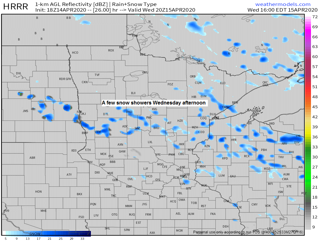
Will have some scattered flurries and snow showers across the Northland this evening and possibly again Wednesday afternoon, this is all due to the very cold air aloft combined with some warmer air down here near the surface thanks to a little sun, otherwise expect partly to mostly cloudy skies tonight and Wednesday.
Lows tonight will be in the single digits and teens with highs Wednesday in the upper 20s to middle 30s. Note: It’s not out of the question that a few locations in northern Minnesota fall to around zero Wednesday morning.
Mainly dry late this week with highs Thursday in the 30s, but on Friday some of us may climb into the lower 40s which is still a good 10 degrees below normal for this time of year, but on Saturday hang on to your shorts as we could crack the 50 degree mark in parts of the Northland, but this could also be accompanied by a few rain showers as a cold front moves SE across the area.
Forecast for Duluth and Superior
.Tonight… Cold. A few flurries this evening otherwise partly to mostly cloudy. Low 12 to 17. Wind northwest 10 to 20 mph.
.Wednesday… Partly to mostly cloudy. A few flurries or snow showers possible. High 30 to 35. Wind northwest 10 to 20 mph.
.Thursday… Partly cloudy. High 34 to 39. Wind northwest 10 to 20 mph.
| Normal temperatures for April 15 High 49 Low 30 Sunrise Wednesday 6:20 AM CDT Sunset Wednesday 7:58 PM CDT |
Thanks for reading!
Tim
Leave a Reply