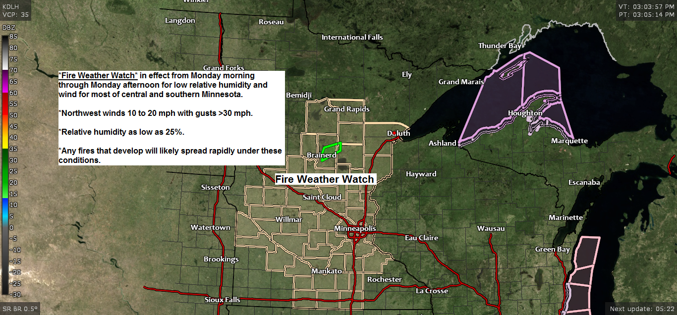
A fire weather watch is in effect for Monday for most of central and southern Minnesota including southern portions of the Northland and the cities of Grand Rapids, Walker, Duluth, Brainerd and Hinckley. A fire weather watch means that critical fire weather conditions are forecast to occur. Listen for later forecasts and possible Red Flag Warnings.
A few light showers (rain/snow) late tonight in far northern Minnesota, then we could see shower coverage increase a bit from late Monday morning through the afternoon with some of the showers in the form of snow or graupel.
Simulated radar forecast valid from Midnight tonight to 7 PM Monday.
Source: 18z NAM-WRF model 4.19.2020; https://weathermodels.com/

Looks like another cool week ahead across the Northland, but probably not quite as chilly as last week.
Note: Normal highs across the Northland this week start off in the low to mid 50s on the 20th, warming to the mid to upper 50s on the 25th. Normal lows are right around 30 or in the lower 30s this week.
Source: 12z European ensemble model 4.19.2020; https://weathermodels.com/

Check out this temperature contrast for Tuesday, April 21, 2020. Note: The 60s and 70s over the Dakotas on Tuesday likely won’t be making it into the Northland on Wednesday as the warm air gets squashed south.
Source: 18z RGEM model 4.19.2020; https://www.tropicaltidbits.com/

Parts of the Northland could see a little snow or rain sometime in the Tuesday afternoon to Wednesday morning time frame. Note: A light coating of snow accumulation is possible over parts of northeast Minnesota and northwest Wisconsin especially Tuesday night.
Source: 12z European model 4.19.2020; https://weathermodels.com/

Look at this beast of a storm which was located east of New England today.
Source: Goes-16 visible imagery 4.19.2020; https://weather.cod.edu/

It’s been a stormy Sunday across the deep south as clusters of strong to severe thunderstorms move east across that area today.
Through 4 PM CT Sunday there have been ~50 severe weather reports stretching from eastern Texas to South Carolina. Damaging wind and large hail make up the majority of the reports so far today.
Source: Goes-16 sandwich imagery 4.19.2020; https://weather.cod.edu/

Temperature and Precipitation report for Duluth, Minnesota for April 12 to April 18, 2020.
| High Temperatures/Departure from Normal 4.12: 35 F/-12 degrees below normal 4.13: 33 F/-15 degrees below normal 4.14: 28 F/-21 degrees below normal 4.15: 33 F/-16 degrees below normal 4.16: 42 F/-8 degrees below normal 4.17: 45 F/-5 degrees below normal 4.18: 55 F/+4 degrees above normal Low Temperatures/Departure from Normal 4.12: 28 F/-1 degree below normal 4.13: 19 F/-10 degrees below normal 4.14: 14 F/-15 degrees below normal 4.15: 14 F/-16 degrees below normal 4.16: 19 F/-11 degrees below normal 4.17: 20 F/-11 degrees below normal 4.18: 33 F/+2 degrees above normal Note: Average temperature in Duluth for the week of April 12, 2020: 29.9 degrees; -9.6 degrees below average. Source: https://www.dnr.state.mn.us/ Total Precipitation: Trace Normal: 0.59″ Departure: -0.59″ below normal State Average for Minnesota for the week of April 12, 2020 Temperature: 30.1 degrees Departure: -13.6 degrees below average Precipitation: 0.29″ Departure: -0.29″ below average |
Last week was cold and dry across the Northland!
Average temperature, departure from mean for the week of April 12, 2020. Source: https://mrcc.illinois.edu/

Total precipitation, departure from mean for the week of April 12, 2020.

…Weather Summary…
Some of us woke up to a little coating of snow this morning thanks to some vigorous snow showers which moved through parts of the Northland early today.
Lots of sunshine across the area this afternoon with highs in the upper 30s to middle 40s (around 10 degrees below normal for April 19)
No major storms impacting our area this week, but there will be a couple of systems which will bring occasional precipitation to northeast Minnesota and northwest Wisconsin.
Tonight will feature partly to mostly cloudy skies. A few rain or snow showers are possible in northern Minnesota late tonight. Lows will be in the 30s with a southwest wind 5 to 15 mph.
Scattered rain showers are expected on Monday, but will probably squeeze out a bit of sun as well. An area of low pressure will remain north of us on Monday while a cold front moves SE through the area. Shower coverage could increase during the afternoon as this cold front approaches. A colder air mass will begin to push SE across the area later in the day which could cause the rain showers to change to snow showers, and there is also a possibility for some graupel (soft hail) Monday afternoon-early evening as steeper lapse rates develop.
Highs on Monday will be in the 40s to lower 50s, but could drop off a bit during the afternoon. Winds will be out of the southwest or northwest 10 to 20 mph with gusts to 30 mph.
Most of Tuesday looks dry, but chances for some snow or rain increase later in the day into early Wednesday morning as another area of low pressure approaches from the NW while a baroclinic zone intensifies across the region. Highs on Tuesday are forecast to range from the middle 30s to middle 40s.
Forecast for Duluth and Superior
.Tonight… Partly cloudy this evening then partly to mostly cloudy overnight. Low 30 to 35. Wind becoming southwest 10 to 20 mph.
.Monday… Breezy. Scattered rain showers. Partly sunny. High 45 to 50. Wind west 15 to 30 mph becoming northwest.
.Tuesday… Partly cloudy. High 37 to 42. Wind northwest 10 to 20 mph.
| Normal temperatures for April 20 High 52 Low 32 Sunrise Monday 6:11 AM CDT Sunset Monday 8:05 PM CDT |
Thanks for reading!
Tim
Leave a Reply