Talk about quick weather changes! We saw a little bit of everything in the Northland today, ranging from clouds, sun, gusty winds, rain showers, wet heavy snow showers and even some graupel (soft hail) Weather nerds love this kind of stuff! Note: Duluth Airport picked up 0.2″ of wet heavy snow with a squall around 4 this afternoon.
Goes-16 visible satellite loop from today, Monday, April 20, 2020.
Source: https://weather.cod.edu/

Note: Seeing a few power outages pop-up in parts of the Northland this afternoon. Could be due to the strong gusty winds we’ve been getting today.
Minnesota Power https://www.mnpower.com/OutageCenter/OutageMap
Lake Country Power http://outage.lcp.coop/#viewer-menu-parent
Another lobe of cold air moving south today, and with such a chilly air mass aloft, it’s no surprise we saw brief heavy rain, wet snow and graupel showers/squalls in the Northland this afternoon.
Source: https://www.spc.noaa.gov/


Will continue to see a few showers of rain, wet snow and graupel across the Northland this evening, then mainly dry weather overnight through about midday Tuesday, but then late Tuesday afternoon we may see a narrow band of wet snow develop in a NW-SE band, but the computer models are all over the place as to where this band sets up.
Source: 18z NAM-WRF model 4.20.2020; https://weathermodels.com/

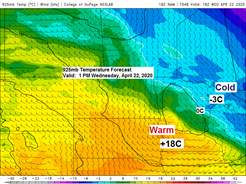
Looking at quite a temperature contrast setting up for Wednesday with 70s possible across much of southwest and southern Minnesota while temps around Lake Superior struggle to get out of the 30s thanks to a breeze out of the NE.
Source: 12z NAM-WRF model 4.20.2020; https://weathermodels.com/

…Weather Summary…
Scattered mixed showers of rain, wet snow and some graupel will continue to move S-SE across the Northland this evening with brief heavy squalls possible.
Looks mainly dry overnight through midday Tuesday under clear to partly cloudy skies.
Lows tonight will be in the teens and 20s. Highs on Tuesday ranging from around 30 in the tip of the Arrowhead to the low-mid 40s in parts of east-central Minnesota and northwest Wisconsin.
Breezy northwest winds of 10 to 20 mph with gusts >30 mph will continue tonight. Winds diminish to 10 to 15 mph by Tuesday afternoon with winds becoming east Tuesday night.
The mid to late week period looks cool as an easterly wind locks in between an area of high pressure to our north and low pressure to our west and south. Coolest temps should be found near Lake Superior, with temps a tad milder farther inland, but still below normal for late April. Note: There could be a little bit of rain, wet snow or patchy freezing rain at times on Wednesday, but the pattern looks pretty dry around here later this week as most of the precip stays to our south the way it looks now, but should the precip shield work its way farther north, then some parts of the Northland could see some accumulating snow or rain later this week.
Forecast for Duluth and Superior
.Tonight… Breezy. Isolated snow or rain showers this evening. Partly to mostly cloudy. Low 20 to 25. Wind north to northwest 15 to 30 mph.
.Tuesday… Mostly sunny with increasing cloudiness later in the day. High 39 to 44. Wind northwest 10 to 15 mph.
.Wednesday… Mostly cloudy. Some wet snow or rain possible at times. High 35 to 40. wind east 10 to 20 mph.
| Normal temperatures for April 21 High 52 Low 32 Sunrise Tuesday 6:09 AM CDT Sunset Tuesday 8:06 PM CDT |
Thanks for reading!
Tim
Leave a Reply