Chances for some snow, rain, patchy sleet and freezing rain are in the forecast across the Northland beginning later tonight and lasting through Wednesday evening. No major accumulations of snow or ice are expected with little impact to travel, but it’s possible we could see a narrow band or two of heavier precipitation develop between late tonight and Wednesday afternoon, and if this occurs, then there is a chance for a quick 1-3″ of snow where-ever these bands set up, but model guidance is all over the place as to where these bands of heavier precipitation will set up, if they develop at all.
Simulated radar valid from 7 PM this evening to 7 PM Wednesday.
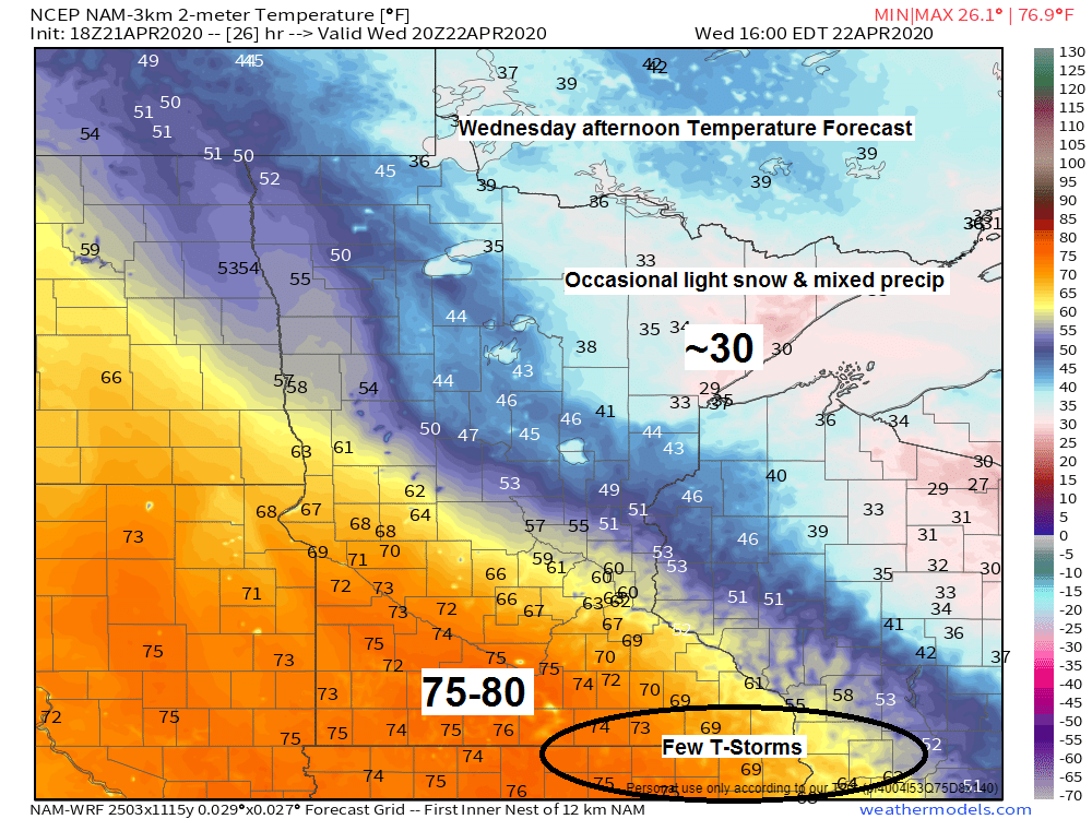
Source: 18z NAM-WRF model 4.21.2020; https://weathermodels.com/

There’s a large area of warm temperatures (70+ degrees) extending from Alberta and Saskatchewan, SE through much of the Northern and Central Plains today, but this warmth won’t make it into the Northland as it gets pushed S-SE thanks in part to a developing NE flow off Lake Superior.
Source: RTMA model; https://lab.weathermodels.com/

It’s been a cool and dry April across the Northland with average temperatures so far for the month running 1 to nearly 5 degrees below average while precipitation totals for the month have been anywhere from a quarter to over an inch below average.
| April 2020 Climate Stats thru the 20th Hibbing, Minnesota Average temperature: 31.6 F Departure: -4.9 degrees below average International Falls, MN: Average temperature: 32.0 F Departure: -4.9 degrees below average Total precipitation: 0.65″ Departure: -0.27″ below average Duluth, MN: Average temperature: 34.4 F Departure: -2.9 degrees below average Total precipitation: 0.42″ Departure: -1.07″ below average Ashland, WI Average temperature: 36.1 F Departure: -1.1 degrees below average Brainerd, MN Average temperature: 37.9 F Departure: -3.4 degrees below average Total precipitation: .63″ Departure: -0.19″ below average |
Average temperature, departure from mean for April 2020 (thru the 20th) Source: https://mrcc.illinois.edu/

Total precipitation, percent of mean for April 2020 (thru the 20th)

Severe weather outbreaks are possible Wednesday and Thursday across the Southern Plains into the southeast US with enhanced (orange) and slight (yellow) risks of severe thunderstorms for both days. Large hail, damaging winds and some tornadoes are possible Wednesday and again for Thursday.
Source: SPC; https://www.pivotalweather.com/
Wednesday’s risk area shown below.

And here’s Thursday’s outlook

Forecast for Duluth and Superior
.Tonight… Increasing cloudiness. Some light snow or sleet possible overnight. Low 29 to 33. Wind northwest 5 to 15 mph becoming east late.
.Wednesday… Breezy. Some light snow or rain possible at times with patchy sleet also possible. Considerable cloudiness. High 33 to 38. Wind east to northeast 15 to 25 mph.
.Thursday… Partly to mostly cloudy. High 35 to 40. Wind east to northeast 10 to 20 mph.
| Normal temperatures for April 22 High 53 Low 33 Sunrise Wednesday 6:08 AM CDT Sunset Wednesday 8:07 PM CDT |
Thanks for reading!
Tim
Leave a Reply