-Some rain is in the forecast for Friday, especially during the afternoon and evening. Highs on Friday are forecast to be in the 50s and 60s with 40s near Lake Superior as easterly winds increase to around 10 to 20 mph.
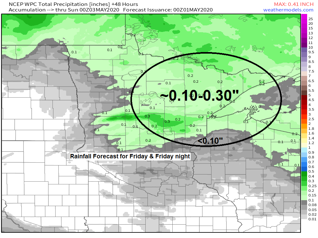
-An area of low pressure with its warm front and cold front will move east out of the Northern Plains and into the upper Midwest on Friday with southerly flow ahead of this system drawing moisture northward into our area. Model guidance is showing precipitable water values increasing to around 0.75 to 1.00″ in most of the Northland Friday afternoon, so this does raise the risk for a few heavier downpours, but mostly looking at light to moderate rain showers with rainfall totals by late Friday night generally in the one-tenth to three-tenths inch range.

Here’s a look at our system for Friday – It’s over the Rockies today and is heading off to the ENE.
Source: Goes-16 water vapor imagery 4.30.2020; https://weather.cod.edu/

There could be a few showers over western parts of the Northland Friday morning, but shower chances increase from SW-NE during the afternoon with rain showers continuing into Friday night before ending early Saturday morning.
Simulated radar forecast valid from 7 AM Friday to 7 AM Saturday.
Source: 18z NAM-WRF model 4.30.2020; https://weathermodels.com/

Severe thunderstorm events usually start to ramp up in Minnesota and Wisconsin during the month of May – On average here’s a look at how many tornadoes occur in May (1989-2013 climate period)
Source: https://www.spc.noaa.gov/wcm/

May begins on Friday – Here are the averages for May at Duluth, Minnesota.
| Averages for May Normal high on the 1st: 57 F Normal high on the 31st: 67 F Normal low on the 1st: 36 F Normal low on the 31st: 45 F Temperature: 51.4 F Precipitation: 3.23″ Snowfall: 0.4″ Number of days with a high of at least 70 F: 6 Number of days with a high of at least 80 F: 2 Note: Average date for first 80 degree temperature is May 23rd Number of days with at least 0.1″ snowfall: 1 Records for May Warmest: 57.7 F set in 2018 Coldest: 38.8 F set in 1907 Wettest: 7.99″ set in 1899 Driest: 0.15″ set in 1976 Snowiest: 13.3″ set in 2019 Astronomical Data for May Sunrise on the 1st: 5:53 AM CDT Sunrise on the 31st: 5:18 AM CDT Sunset on the 1st: 8:20 PM CDT Sunset on the 31st: 8:54 PM CDT |
Forecast for Duluth and Superior
.Tonight… Clear to partly cloudy. Low 38 to 43. Wind variable around 10 mph.
.Friday… Increasing cloudiness. Afternoon and evening showers. High 58 to 63 but cooler near Lake Superior. Wind becoming east to southeast 10 to 20 mph.
.Saturday… Breezy. Mostly sunny. High 65 to 70. Wind west 15 to 25 mph.
| Normal temperatures for May 1 High 57 Low 36 Sunrise Friday 5:53 AM CDT Sunset Friday 8:20 PM CDT |
Thanks for reading!
Tim
Leave a Reply