Extreme (red) to High Fire Danger (yellow) covers all of Minnesota through this evening.
Note: The fire situation is rated as explosive in the extreme category.
Source: https://www.dnr.state.mn.us/

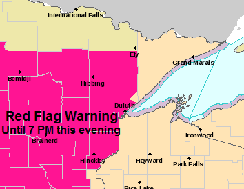
-Red Flag Warning continues until 7 PM this evening for portions of north-central, northeast and east-central Minnesota (hot pink area on map)
-Winds west 10 to 20 mph with gusts up to 35 mph.
-Relative humidity as low as 21 percent.
-Any fires that develop will likely spread rapidly. Outdoor burning is not recommended.
Source: https://www.weather.gov/dlh/

Temperatures reached the lower 70s this afternoon in Downtown Duluth and in Superior (warmest temps of 2020 up to this point)
However, the Duluth Airport didn’t hit 70 degrees today, so the wait continues for the first official 70 degree temperature of 2020 in Duluth since weather records are kept at the Duluth Airport.

-Sunday is looking cooler in most of the Northland with highs a good 15 to 20 degrees cooler in Duluth and Superior compared to what we saw for highs on Saturday. Temperatures across the Northland on Sunday are forecast to be in the middle 40s to middle 50s with a north or northwest wind 10 to 20 mph. Note: There could be a few light showers or flurries early Sunday morning in far northern Minnesota.
| Highest Wind Reports across the Northland for Saturday, May 2, 2020. Source: https://www.weather.gov/dlh/ Blatnik Bridge: 53 mph Duluth Airport: 49 mph Ashland, WI: 44 mph Walker, MN: 44 mph Northome, MN: 42 mph Duluth Harbor: 40 mph Chisholm-Hibbing Airport: 40 mph Grand Rapids, MN: 38 mph Two Harbors, MN: 38 mph Brainerd, MN: 37 mph Superior Airport: 37 mph Cloquet, MN: 36 mph Ely, MN: 36 mph Grand Marais, MN: 36 mph Isabella, MN: 34 mph |
I’m still keeping an eye on a system which could affect parts of the Northland early next week – Rain and possibly some snow or a wintry mix could impact parts of the area in the Monday night-Tuesday night time frame. Stay tuned.

A chilly pattern setting up for next weekend (May 8-10)
The Minnesota Fishing Opener is one week from today, Saturday, May 9, 2020, and it looks rather chilly across the region.
A strong upper level low (Polar Vortex like) is forecast to drop SE out of Hudson Bay and Ontario late next week which puts the Northland in a chilly N-NW flow aloft.
Model guidance has Saturday morning temperatures in the 20s with teens even possible across northern Minnesota. Temperatures Saturday afternoon (May 9) will only warm into the upper 30s to around 50 degrees across the Northland. Winds are forecast to be out of the north to northwest at 10 to 20 mph. Note: It does look dry at the moment for next Saturday.
Source: 12z European ensemble model 5.2.2020; https://weathermodels.com/

Forecast for Duluth and Superior
.Tonight… Windy. Partly cloudy. Low 35 to 40. Wind west to northwest 15 to 25 mph with higher gusts.
.Sunday… Breezy and cooler. Partly to mostly cloudy. High 47 to 52. Wind northwest 15 to 25 mph.
.Monday… Increasing cloudiness. High 44 to 49 but cooler near Lake Superior. Wind east 10 to 20 mph.
| Normal temperatures for May 3 High 58 Low 37 Sunrise Sunday 5:50 AM CDT Sunset Sunday 8:22 PM CDT |
Thanks for reading!
Tim
Leave a Reply