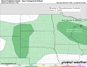
Isolated to scattered coverage of showers and thunderstorms are possible in northeast Minnesota and northwest Wisconsin on Monday, mainly during the morning and afternoon.
Higher instability (mostly elevated CAPE) will advect eastward into the Northland on Monday while a warm front moves ENE out of western Minnesota. Lift associated with the advancing warm frontal boundary, combined with warmer and more humid air advecting into the Northland should be enough to produce isolated to scattered coverage of showers and thunderstorms on Monday. Note: The threat for severe thunderstorms is on the low side on Monday with a Marginal or Level 1 risk for an isolated severe thunderstorm with wind and hail being the main threats along with lightning and downpours which will occur in any thunderstorm.
Source: 12z European model 5.31.2020; https://weathermodels.com

Not looking at a whole lot of rain or widespread rains on Monday with rainfall totals generally in the trace to quarter inch range, but where thunderstorms occur heavier rainfall totals will be possible.
Source: https://lab.weathermodels.com

Here’s a look at the simulated radar forecast for Monday (7 AM to 7 PM)
Source: 18z NAM-WRF model 5.31.2020; https://weathermodels.com

A dry air mass currently over the Northland this afternoon will be replaced by somewhat more humid conditions by Monday afternoon as dew points climb into the 50s and lower 60s, but this more humid air mass won’t stick around long as drier air moves back in come Tuesday.

A rather large temperature contrast appears to be setting up Monday afternoon with a very warm to hot air mass covering western portions of Minnesota while cooler weather will be found in northeast Minnesota and northwest Wisconsin. Note: Near 80 degree temps should return in Duluth on Tuesday as winds shift from east on Monday to west on Tuesday.

| A look back at last week’s weather in Duluth, Minnesota May 24th to May 30th, 2020 Warmest temperature: 81 degrees on the 27th Coldest temperature: 40 degrees on the 30th Average temperature for the week of May 24th: 61.3 degrees; +6.8 degrees above normal. Total precipitation: 0.40″ Normal: 0.76″ Departure: -0.36″ below normal 2 days had at least 0.01″ of precipitation | |
Another chilly morning across the Northland, check out some of these low temperature reports from Sunday morning, May 31, 2020.
Source: https://www.weather.gov/dlh/
Hibbing, MN: 27F
Silver Bay Airport: 28F
Pine River, MN: 28F
2 E Celina, MN: 28F
Aitkin, MN: 28F
3 E Wright, MN: 29F
Crane Lake, MN: 30F
Eveleth, MN: 30F
Bigfork, MN: 30F
Solon Springs, WI: 30F
Cotton, MN: 30F
Walker, MN: 31F
Embarrass, MN: 31F
Longville, MN: 32F
Moose Lake, MN: 32F
Winter, WI: 32F
Hayward, WI: 33F
Superior Airport: 33F
Brainerd, MN: 34F
International Falls, MN: 34F
Hinckley, MN: 34F
McGregor, MN: 34F
Babbitt, MN: 34F
3 E Orr, MN: 34F
4 W Clam Lake, WI: 34F
Ashland, WI: 35F
Note: Hibbing, Minnesota tied their record low temperature for May 31st with a low this morning of 27 degrees, this ties the record low temperature for the date which was set in 2009. Hibbing also tied their record low temperature on May 30th, 2020.
Thanks for reading!
Tim
Leave a Reply